
Krebeck
| coat of arms | Germany map | |
|---|---|---|

|
Coordinates: 51 ° 35 ' N , 10 ° 7' E |
|
| Basic data | ||
| State : | Lower Saxony | |
| County : | Goettingen | |
| Joint municipality : | Gieboldehausen | |
| Height : | 172 m above sea level NHN | |
| Area : | 12.27 km 2 | |
| Residents: | 1033 (Dec. 31, 2019) | |
| Population density : | 84 inhabitants per km 2 | |
| Postal code : | 37434 | |
| Area code : | 05507 | |
| License plate : | GÖ , DUD, HMÜ, OHA | |
| Community key : | 03 1 59 022 | |
| Address of the municipal administration: |
Kirchring 17 37434 Krebeck, Germany |
|
| Website : | ||
| Mayor : | Frank Dittrich ( independent ) | |
| Location of the community Krebeck in the district of Göttingen | ||
  |
||

Krebeck is a municipality in southern Lower Saxony (Germany). It is located in the district of Göttingen on the western edge of the Untereichsfeld and belongs to the Gieboldehausen community .
geography
Krebeck is located about 13 kilometers east of Göttingen and 11 kilometers northwest of Duderstadt on the edge of the fertile Golden Mark , in the western district there are wooded hills ( Westerberg : 275 m). The Ellerbach , a tributary of the swell, flows through the village . In the immediate vicinity of the municipality, the federal road 27 runs from Göttingen to Herzberg am Harz .
The neighboring town of Renshausen , about two kilometers to the northwest, is a district of Krebeck. Other neighboring towns are Ebergötzen in the southwest, Lake Constance in the north and Wollbrandshausen in the east.
The geodetic center of Germany is located in Krebeck . In 2016 it became known that a deceased geologist had found archosaurs' footsteps during excavations in the now renatured clay pit Krebeck . The Lower Saxony State Office for the Preservation of Monuments made an imprint of an existing stamp .

history
The place was mentioned in 1256 as Crebecke, a later spelling was Kreybecke (1340), an earlier Crebike (1183). The name should mean Krähenbach or Kranichbach. During the years up to 1649 the place is listed under the names Crebecke (1256), Krebecke (1266), Kreybecke (1340) and Grebicke (1649). A document in which Krebeck is mentioned dates back to 1256. At that time, Widekind von Bösekendorp allocated income from its allod in Krebeck to Weende Monastery . Five years later, in 1261, a parish priest, the plebanus Hermannus, is named for the place. In 1340 the brothers Arnold and Henry of Rorungen (were Roringen ) by Duke Henry of Brunswick in goods in Krebeck invested . During the year 1496 the place came under the church ban. The trigger for this dispute was a conflict between Krebeck, which was sovereignly subordinate to the Gieboldehausen office, and the St. Michael monastery in Hildesheim , where it was about a pasture in the Sautal. Only after years, and at the endeavors of the bailiff of Lindau , could the ban from church be lifted again. During the Reformation, a Franciscus Symon counted as pastor in Krebeck, it is mentioned that the "mangy sheep", probably Protestants from the Gieboldehausen office, came running to him. It was not until 1605 that most of the families returned to the Catholic Church.
At the end of the 15th century, after Dietrich von Hardenberg acquired half of the town of Lindau for 4,300 Rhenish guilders in 1492 , a dispute arose the following year between the residents of Renshausen and the Untersassen in Krebeck over the pasture on the Sudal meadow, which was in the Feldmark Renshausen, however, was illegally used by the Krebeckern. The St. Michael Monastery in Hildesheim obtained an arbitration award, which resulted in the Krebecker refraining from using the Hutweide and paying the legal costs. These did not, however, turn to it, sent the abbot a feud and robbed and murdered in Renshausen before setting the place on fire, whereupon they were banned . The attempt at an amicable settlement through the intervention of Dietrich von Hardenberg failed, Bishop Berthold von Hildesheim rather warned Dietrich to additionally protect the monastery property from the wild goings-on of the Krebecker. The dispute between the two villages was not settled peacefully until 1499, on the Wednesday after Reminiscere Ludolf von Bortfeld stood up for the abbot's side, Dietrich von Hardenberg for the Krebecker and agreed that the communities could continue to use the pasture, the Krebecker should send 2 guilders to Hildesheim to break the ban.
Similar to the other villages of the Untereichsfeld , Krebeck also suffered considerably from the Thirty Years 'War and the Seven Years' War . In addition, the place was hit by the cholera epidemic that broke out in the Unterereichsfeld in 1850 . In both world wars, 49 residents of the place were killed, while nine went missing. The place also had to complain about fires more frequently in modern times, for example a large fire destroyed ten houses and 14 barns in May 1917, and in August 1934 four farms fell victim to the fires. From 1973 Krebeck became a member of the Gieboldehausen joint community .
Incorporations
On January 1, 1973 the community of Renshausen was incorporated.
politics
Municipal council
The local council from Krebeck consists of eleven council members, including the part-time mayor.
| SPD | CDU | Green | total | |
| 2006 | 1 | 9 | 0 | 10 seats |
| 2011 | 0 | 9 | 2 | 11 seats |
| 2016 | 0 | 9 | 2 | 11 seats |
(Status: local election on September 11, 2016 )
badges and flags

coat of arms
Hoist flag

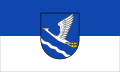
Blazon : "In blue a rising, gold- (yellow) - armored silver (white) crane over a lowered, sloping, silver (white) wavy bar (wavy band)."
The coat of arms designed by Fritz Reimann from Fuhrbach was approved by the Lower Saxony Ministry of the Interior on April 11, 1951. The place name, the oldest forms of which are Crebecke (1264) and Kreybecke (1340), are said to mean crows or cranes stream. It can also be observed that every year cranes come down for a short rest in a quarry near the village.
Description of the flag: "The flag has blue and white stripes with a coat of arms in the middle."
Culture and sights
Parish Church of St. Alexander and Brothers

The Catholic parish church of St. Alexander was built in 1716 in the Eichsfeld Baroque . 1724 which took place consecration of the church by the Erfurt Bishop Johann Joachim Hahn. It represents a red sandstone block construction with a slightly retracted choir. Construction workers from Tyrol were also involved in the construction of the church . An inscription on the south wall shows the builder, it reads JOAN GEORG KULMAN MAUR MEISTER VON GERRENROT . Similar to other churches in the Untereichsfeld , the one from Krebeck had a previous building in its place, so the church tower can be dated to the 16th century. The pointed helmet, which acts as the roof of the tower, on the other hand, dates from the 19th century. The outer walls have a simple design without profiling, but the walled-up oculi, which are located above the arched windows, are clearly recognizable. The figure of the church patron St. Alexander was placed in a niche above the tower portal, which consists of pilasters and entablature. The keystone was placed on the north portal of the church. It bears the date of completion in 1716 along with an eight-spoke Mainz wheel . In the church hall, spanned by a mirror vault, one finds side walls with pilaster strips and the unusual construction of the ribbed vault . Its specialty is that no end point of the ribs can be seen in the area of the choir. The inventory has been preserved in a beige and gold version and comes from the Baroque or late Baroque-Classicist period, while the two-story high altar with its twisted columns, putti , flower hangings, shells and vases dates from the middle of the 18th century. The altarpiece depicts the crucifixion of Jesus . Individual forms of the side altar range from style to Rococo and have a compact wall character. This contrasts with the graceful, colorful Baroque Madonna , the main character of the side altar. Since November 1st, 2014 the church belongs to the parish “St. Kosmas and Damian ”in Bilshausen .
Club life
The Renshäuser Blasmusik and the Lauseberger Big Band, as well as the bands Lauschgift, Jack & the Daniels, Blue Velvet and Radio Active are located in the community. The annual "Open Air Krebeck", which is organized by KSC neV and takes place on the Krebeck sports field, should be mentioned as a musical highlight.
Numerous clubs such. B. the DJK Krebeck, youth group, Kolping family, Catholic women, MGV “St. Joseph “Krebeck, volunteer fire brigade , carnival society, shooting comradeship, theater group and a skat club ensure a diverse community life.
Economy and Infrastructure
Krebeck's economic structure has always been characterized by a rural and artisanal character. Over the decades until its closure in 1972, the former brickworks played an extremely important role in the source of income for many Krebecker residents. The brickworks was founded in 1860. Today the local riding hall has taken the place of the former business enterprise.
- photos

The center stone

Shield on the center stone

Place-name sign


literature
- Bettina Bommer, Sigrid Dahmen: The history of the places Renshausen and Krebeck , Duderstadt, Mecke, 2007
Web links
Individual evidence
- ↑ State Office for Statistics Lower Saxony, LSN-Online regional database, Table 12411: Update of the population, as of December 31, 2019 ( help ).
- ↑ Marco Schulze: The secret of Krebecker dinosaur feet at ndr.de from August 29, 2016
- ^ Bernd Hermann: Contributions to the Göttingen Environmental History Colloquium 2010–2011, 2011, p. 220
- ^ Hans Friedrich Georg Julius Sudendorf: Document book on the history of the dukes of Braunschweig and Lüneburg and their lands. First part up to 1341 . No. 680 . Carl Rümpler, Hanover 1859.
- ^ Johann Wolf: History of the Hardenberg family. I. Part with 132 documents . Baier, Göttingen 1823, p. 100 .
- ^ Federal Statistical Office (ed.): Historical municipality directory for the Federal Republic of Germany. Name, border and key number changes in municipalities, counties and administrative districts from May 27, 1970 to December 31, 1982 . W. Kohlhammer GmbH, Stuttgart and Mainz 1983, ISBN 3-17-003263-1 , p. 206 .
- ↑ https://wahlen.kdgoe.de/2016kw/Daten/159402_000126/index.html
- ↑ Wappenbuch Landkreis Duderstadt, 1960, pp. 17 + 53
- ^ Main statute of the Krebeck community
- ↑ Krebeck's baroque church celebrates its 300th anniversary. goettinger-tageblatt.de from September 11, 2016, accessed on September 9, 2017.
Adelebsen | Bad Grund (Harz) | Bad Lauterberg in the Harz Mountains | Bad Sachsa | Bilshausen | Lake Constance | Bovenden | Charging | Dransfeld | Duderstadt | Boar idols | Elbingerode | Friedland | Gieboldehausen | Same | Göttingen | Hann. Münden | Hattorf am Harz | Herzberg am Harz | Hörden am Harz | Jühnde | Krebeck | Landolfshausen | Niemetal | Obernfeld | Osterode am Harz | Jump | Rollshausen | Rosdorf | Rüdershausen | Scheden | Seeburg | Seulingen | Staufenberg | Waake | Walkenried | Wollbrandshausen | Wollershausen | Wulften am Harz
Community-free area in the district of Göttingen
Harz (district of Göttingen)