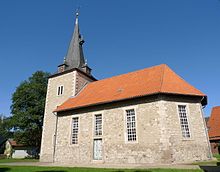
Osterhagen
|
Osterhagen
City of Bad Lauterberg
Coordinates: 51 ° 35 ′ 29 ″ N , 10 ° 29 ′ 3 ″ E
|
|
|---|---|
| Height : | 325 m |
| Residents : | 800 |
| Incorporation : | July 1, 1972 |
| Postal code : | 37431 |
| Area code : | 05524 |
Osterhagen is a street village in the southwestern Harz foreland and district of Bad Lauterberg in the district of Göttingen (formerly Osterode ) in southern Lower Saxony , Germany, with almost 800 inhabitants. The place is on the southern Harz between Bad Lauterberg and Bad Sachsa .
history
The first documented mention of 1257 is already identical to the current spelling. As a compound of the old Saxon ostar- and -hagen , the name means enclosed piece of land in the east . The first settlers are likely to come from the much older Bartolfelde , which is west of the village.
On July 5, 1944, a subcamp of the Mittelbau-Dora concentration camp for around 300 prisoners was built in a former brickworks near Osterhagen , with the goal of completing the Helmetalbahn route between Osterhagen and Nordhausen , which was not achieved . After several death marches on foot and an evacuation transport by train, most of the prisoners were murdered in the massacre in the Isenschnibbe barn on April 13, 1945 in Gardelegen . Today there is a memorial stone and an information board on the edge of the former camp site. Six unknown concentration camp prisoners are buried in the local cemetery.
On July 1, 1972, Osterhagen was incorporated into the city of Bad Lauterberg through the regional reform in Lower Saxony .
nature
The karst hiking trail leads south of Osterhagen through the Steingrabental - Mackenröder Wald nature reserve . Not far from Osterhagen is the Weingartenloch , a supposed treasure cave in the Karst , around which many legends are entwined.
Web links
Individual evidence
- ↑ Uwe Ohainski, Jürgen Udolph : The place names of the district of Osterode (= publications of the Institute for Historical Research at the University of Göttingen . Volume 40 ). Publishing house for regional history, Bielefeld 2000, ISBN 3-89534-370-6 , p. 118–119 ( adw-goe.de [PDF; 2.6 MB ]).
- ↑ Firouz Vladi : The construction of the Helmetalbahn , Verlag Mecke Druck, Duderstadt 2000, ISBN 978-3-932752-55-1
- ↑ Concentration Camp Memorials. In: Remembering in Southern Lower Saxony. Retrieved July 20, 2018 .
- ^ Federal Statistical Office (ed.): Historical municipality directory for the Federal Republic of Germany. Name, border and key number changes in municipalities, counties and administrative districts from May 27, 1970 to December 31, 1982 . W. Kohlhammer GmbH, Stuttgart / Mainz 1983, ISBN 3-17-003263-1 , p. 215 .
- ↑ "Steingrabental - Mackenröder Forest" nature reserve. Lower Saxony State Agency for Water Management, Coastal Protection and Nature Conservation, accessed on October 25, 2010 .
- ↑ The Nixei and the Weingartenloch. karstwanderweg.de, accessed on October 25, 2010 .
- ↑ The Weingartenloch. karstwanderweg.de, accessed on October 25, 2010 .
