Karst hiking trail
| Karst hiking trail | |
|---|---|
 Guide (2007) |
|
| map | |

|
|
| Data | |
| length | 233.2 km |
| location | Lower Saxony , Saxony-Anhalt and Thuringia |
| Supervised by | Harz Club e. V. |
| Markers |
white K in red crossbar on a white background |
| Starting point |
Bad Grund (Harz) 51 ° 49 ′ 3 ″ N , 10 ° 15 ′ 11 ″ E |
| Target point |
Pölsfeld 51 ° 32 ′ 4 ″ N , 11 ° 22 ′ 51 ″ E |
| Type | Long-distance hiking trail |
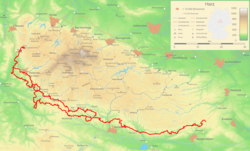
The karst hiking trail is a 233.2 km long, signposted and marked hiking trail in the central German karst landscape of the three districts of Mansfeld-Südharz in Saxony-Anhalt , Nordhausen in Thuringia and Göttingen in Lower Saxony .
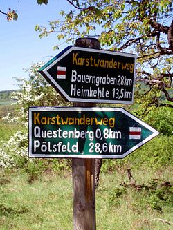
A separate marking was created for the karst hiking trail after 2007. It is the white initial letter K on a red crossbar over a white background.
In 2017, the branch path (21 km) from Lower Saxony's Förste to Bad Grund , which had already been set up and signposted some time before, also became an official part of the Karst hiking trail .
description
It leads from Pölsfeld in Saxony-Anhalt through the karst landscape of the southern Harz Zechstein belt , including through Rüdigsdorf Switzerland , into the Lower Saxony forest . From there, the hiking trail "Wanderbaren Deutschland", certified in 2011 and 2014, runs back on a northern route to the Thuringian district of Nordhausen and meets the southern trail in Gudersleben .
The path opens up numerous natural attractions including caves like the Heimkehle and the Barbarossa cave , sinkholes , sinkholes as the Juessee or Beberteich and Floating island , connected and dischargeless waters like the ox Pfuhl , the ash Hütter pond , the Wiedensee and the boiler sump , moorlands as the Teufelsbad , karst springs like the Rhumequelle and the Teufelsloch , streams and river sinking like the Bauerngraben and the infiltration of the Sieber , as well as numerous gypsum rocks.
The medieval desert areas of Hage , Königshagen and Smerbeke are on the Karst hiking trail.
Stages and circular hiking trails
The following stages are proposed on the official website:
- Herzberg - Scharzfeld - Barbis (14 km)
- Barbis - Bad Lauterberg - Osterhagen (9 km)
- Uftrungen ( Heimkehle , St. Andreas ) - Bauerngraben - Questenberg ( Burg Questenberg , Wallburg Queste, Dinsterbachschwinde ) - Hainrode ( St. Bartholomäus , Ankenbergschwinde ) (21 km)
These long-distance hikes only cover a small part of the karst hiking trail. Therefore, there are also the following circular hiking trails:
- Osterode - Förste - Ührde - Osterode (21.5 km)
- Osterode - Hörden - Düna - Osterode (25.5 km)
- Osterode - Oberhütte - Osterode (20 km)
- Walkenried - Himmelreich - Walkenried (10 km)
- South of Bad Lauterberg : Winkeltal - Butterberg - Eulenstein - Winkeltal (9 km)
- Around the Weser-Elbe watershed : Steina - Nüxei - Bartolfelde - Steina (18 km)
- Tettenborn Colony - Nüxei - Römerstein - Trogstein - Tettenborn Colony (6 km)
- Herzberg - Hörden - Mühlenberg - Herzberg (16 km)
-
Around Scharzfeld :
- Small circular hike (8.5 km)
- Long circular hike: Scharzfeld - Barbis - Scharzfeld (18 km)
- Circular hiking trail in the Hainholz / Beierstein NSG (8.5 km)
- Around Klettenberg (4 km)
- Liebenrode - Steinsee - Liebenrode (8 km)
- Förste - Ührde - Förste (19 km)
- Around Steigerthal (7.5 km)
-
Rüdigsdorfer Switzerland / Krimderode
- Small circular hike (2.5 km)
- Long circular hike: Rüdigsdorf - Petersdorf - Krimderode - Rüdigsdorf (7.5 km)
- Circular hiking trails in the Old Stolberg
- Small circular hike (4 km)
- Long circular hike: Steigerthal - Kalkhütte - Steigerthal (7.5 km)


