
Pölsfeld
|
Pölsfeld
City of Allstedt
Coordinates: 51 ° 31 ′ 38 ″ N , 11 ° 20 ′ 41 ″ E
|
|
|---|---|
| Height : | 241 m above sea level NHN |
| Area : | 11.59 km² |
| Residents : | 383 (Jul 30, 2013) |
| Population density : | 33 inhabitants / km² |
| Incorporation : | January 1, 2010 |
| Postal code : | 06528 |
| Area code : | 03464 |
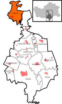  Location of Pölsfeld in Allstedt
|
|
 View of Pölsfeld from the southeast
|
|
Pölsfeld is a district of the city of Allstedt in the district of Mansfeld-Südharz in Saxony-Anhalt .
geography
Pölsfeld is located between Sangerhausen and Hettstedt in the Karst Landscape Biosphere Reserve in western Saxony-Anhalt . Pölsfeld is located on the south-eastern edge of the Harz Mountains in a side valley of the Gonna , framed by mountains with meadows and forests. The approx. 200 km long karst hiking trail to Förste in Lower Saxony begins and ends in Pölsfeld .
history
It was first mentioned in a document in 899 as a Bullisfeld .
In the Middle Ages, the village of Herchensole was located southeast of Pölsfeld .
As of July 3, 2005, the municipality of Pölsfeld belonged to the Allstedt-Kaltenborn administrative community, which has its administrative headquarters in the city of Allstedt. In advance, the municipality of Pölsfeld took legal action against the assignment to the Sangerhausen administrative community on January 1, 2005. Pölsfeld resisted this integration, which had been planned as part of a municipal reorganization with the aim of reducing the number of administrative communities and the resulting dissolution of their former administrative community in the southern Harz . On October 1, 2005, the enlarged VG Sangerhausen was also dissolved and all the communities belonging to it were incorporated into the district town of Sangerhausen . Pölsfeld initially escaped incorporation, but now the citizens sometimes have to cover longer distances to the new Allstedt administrative center. On January 1, 2010, the previously independent municipality of Pölsfeld was finally incorporated into the city of Allstedt together with the municipalities of Beyernaumburg , Emseloh , Holdenstedt , Katharinenrieth , Liedersdorf , Mittelhausen , Niederröblingen (Helme) , Nienstedt , Sotterhausen and Wolferstedt .
church
Economy and Infrastructure
traffic
To the east of the village lies the federal road 86 , which leads from Sangerhausen to Hettstedt . The A 38 motorway , which leads from Halle (Saale) to Göttingen , is located south of Pölsfeld. Pölsfeld does not have a railway connection , but is connected to the regional bus network of the Südharz transport company .
Individual evidence
- ↑ Area and population of the districts of Allstedt ( Memento of the original from December 18, 2014 in the Internet Archive ) Info: The archive link was inserted automatically and has not yet been checked. Please check the original and archive link according to the instructions and then remove this notice.
- ↑ StBA: Area changes from January 01 to December 31, 2010
Web links

Allstedt | Beyernaumburg | Einsdorf | Singling | Emseloh | Holdenstedt | Katharinenrieth | Liedersdorf | Mittelhausen | Niederröblingen (helmets) | Nienstedt | Othal | Pölsfeld | Sotterhausen | Angle | Wolferstedt