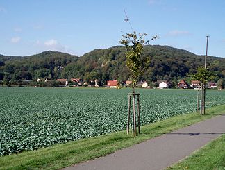
Old Stolberg
| Old Stolberg | |
|---|---|
|
Stempeda on the Old Stolberg |
|
| Highest peak | Königskopf ( 357.7 m above sea level ) |
| location | South Harz |
| Part of the main unit | South Harz Zechstein belt , Thuringian basin (with edge plates) |
| Classification according to | Handbook of the natural spatial structure of Germany |
| Coordinates | 51 ° 32 ' N , 10 ° 55' E |
The Alte Stolberg is a wooded, up to 357.7 m above sea level. NHN high karst plateau of the southern Harz in the district of Nordhausen ( Thuringia ) and the district of Mansfeld-Südharz ( Saxony-Anhalt ) in Germany .
Geographical location
The Alter Stolberg ridge extends in the southern Harz Zechstein belt, particularly in Thuringia; its eastern foothills in Saxony-Anhalt fall into the valley of Krebsbach and Thyra . To the north lies the Harz Mountains, to the south the Goldene Aue through which the Helme flows .
Starting clockwise in the south, the Alte Stolberg lies between the Thuringian communities of Görsbach and Urbach in the south, Leimbach and Steigerthal in the west, Buchholz and Herrmannsacker in the north-west, Stempeda and - beyond that - Rodishain in the north as well as the villages of Rottleberode and in Saxony-Anhalt Uftrungen in the east.
In the northern part of the old Stolberg rises with the Königskopf ( 357.7 m above sea level ) its highest point and in the southeast part is the Reesberg ( 325.2 m above sea level ).
→ for these and other surveys of the Old Stolberg see paragraph Harz of the article List of mountains and elevations in Thuringia
Nature and landscape protection
|
Old Stolberg
|
|
| location | Thuringia and Saxony-Anhalt |
| surface | 6.233 km² |
| WDPA ID | 20730 |
| Geographical location | 51 ° 31 ' N , 10 ° 53' E |
| Setup date | 1961 |
The northern part of the wooded Höhenzugs is a nature reserve Alter Stolberg and large parts of the area are as protected landscape Alter Stolberg reported.
The proportion in the Nordhausen district is 622.7 hectares.
In Saxony-Anhalt, the adjacent nature reserve Alter Stolberg (Saxony-Anhalt) and Grasburger Wiesen in the district of Mansfeld-Südharz are protected with a total area of 28.0 hectares.
particularities
The Heimkehle plaster cave is located in the Reesberg area . There are also ruins of the Grasburg , a medieval refuge, which, according to legend, is the ancestral castle of the Counts of Stolberg .
Web links
Individual evidence
- ↑ Map services of the Federal Agency for Nature Conservation ( information )
- ↑ J. Spönemann: Geographical land survey: The natural spatial units on sheet 100 Halberstadt - Federal Institute for Regional Studies, Bad Godesberg 1970 → online map
- ↑ Nature reserves in the Nordhausen district. Thuringian State Institute for Environment and Geology (TLUG), September 2009, accessed on April 14, 2011 : "The NSG 3" Alter Stollberg "has a unique flora and fauna and represents essential characteristic surface and water forms of the natural area. Parts of the Krebsbachaue are also included in the NSG. ... The area has a long tradition of floristic and faunistic research that goes back to Thal's "Sylva Hercynia". The "Alte Stolberg" is one of the classic entomological research areas in Central Germany. "
- ↑ Nature reserves in Saxony-Anhalt. (No longer available online.) Saxony-Anhalt State Administration Office, 2011, archived from the original on May 17, 2014 ; Retrieved April 13, 2011 . Info: The archive link was inserted automatically and has not yet been checked. Please check the original and archive link according to the instructions and then remove this notice.

