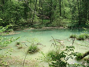
Devil's hole (devil's baths)
| Devil's hole | |
|---|---|
 Devil's hole |
|
| location | |
| Country or region | District of Göttingen ( Lower Saxony ) |
| Coordinates | 51 ° 42 ′ 18 " N , 10 ° 17 ′ 25" E |
| geology | |
| Mountains | resin |
| Source type | Karst spring |
| Exit type | Sinkhole |
| Hydrology | |
| River system | Weser |
| Receiving waters | Apenke → Söse → Rhume → Leine → Aller → Weser → North Sea |
Coordinates: 51 ° 42 ′ 18 ″ N , 10 ° 17 ′ 25 ″ E
The Teufelsloch is a karst spring near Osterode am Harz in Lower Saxony .
description
The Teufelsloch is located southeast of Augustental in the high forest on the Karst hiking trail . It is a circular, marshy sinkhole , filled with greenish-bluish shimmering water. The flowing stream feeds the devil's baths to the west and then flows over the Apenke to the Söse . After heavy rain events , further springs emerge in the bank area, which give the karst water in the Teufelsloch a brownish color. The Teufelsloch is located within the Teufelsbäder nature reserve .
Popular beliefs about the devil's hole
In the past, you saw something threatening in the devil's hole. People could not explain the origin of the blue shimmering water from the uncanny depths. It was said of Wisps in human size, lured the nocturnal wanderer on the bent tree in the hell hole. Others believed that the devil lurked in the water in the form of a huge one-eyed fish with needle-sharp teeth .
See also
Web links
- Say about the devil's hole at karstwanderweg.de
- Teufelsbäder nature reserve on the website of the Lower Saxony State Office for Water Management, Coastal and Nature Conservation (NLWKN)
