Ochsenpfuhl
| Ochsenpfuhl | ||
|---|---|---|

|
||
| Ochsenpfuhl with castle in the background, November 2011 | ||
| Geographical location | Herzberg am Harz , Göttingen district , Lower Saxony | |
| Tributaries | none | |
| Drain | none | |
| Data | ||
| Coordinates | 51 ° 39 '10.4 " N , 10 ° 20' 3.5" E | |
|
|
||
| surface | 1.2 ha | |
|
particularities |
Lake created by sinkhole |
|

|
||
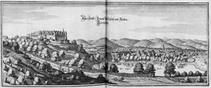
| The Ochsenpfuhl with castle around 1654 | ||
The Ochsenpfuhl is a small lake in the town of Herzberg am Harz , Göttingen district , Lower Saxony .
description
The approximately 12,000 m² lake is located in a sinkhole about 350 meters southeast of Herzberg Castle and about 700 m west of the Juessee . It has no inflows and outflows. The silting bank zones are heavily overgrown and a breeding area for water birds. The water surface is shown much larger on old maps than on current maps.
literature
- Klaus Gehmlich: Field names in the district of Osterode am Harz , Volume 4, M-Sp, Papierflieger Verlag, Clausthal-Zellerfeld 2012, ISBN 978-3-86948-203-3 , p. 67
See also
Web links
Commons : Ochsenpfuhl - Collection of images, videos and audio files
- http://www.harzlife.de/teiche/ochsenpfuhlteich.html
- http://www.herzberg.de/staticsite/staticsite.php?topmenu=260&menuid=271
- Say about the Ochsenpfuhl at karstwanderweg.de
Individual evidence
- ↑ resin map "Herciniae Metalliferae". Bibliothèque nationale de France, accessed on July 21, 2012 .
- ^ Kurhannoversche land survey of the 18th century : sheet 152 Herzberg, Landesvermessung + Geobasisinformation Niedersachsen, Hannover 2003
