
Bauerngraben (Harz)
|
Bauerngraben (Hungersee) |
||
|---|---|---|

|
||
| Peasant ditch; Lake in a full state | ||
| Geographical location | in the Harz near Agnesdorf ; Mansfeld-Südharz district , Saxony-Anhalt | |
| Tributaries | Glasebach | |
| Drain | above ground without drainage | |
| Data | ||
| Coordinates | 51 ° 29 '18 " N , 11 ° 4' 37" E | |
|
||
| Altitude above sea level | 250 m above sea level NHN | |
| surface | 4.3 ha | |
| length | 430 m | |
| width | 150 m | |
|
particularities |
||

The Bauerngraben , also known as Hungersee , is an episodic lake located in the Harz Mountains at the mouth of the Glasebach . It is located near the southern Harz district of Agnesdorf in the Saxony-Anhalt district of Mansfeld-Südharz . The area was placed under nature protection in 1961 and merged into the Questenberg Gypsum Karst Nature Reserve in 1996 .
Geographical location
The Bauerngraben is located in the Lower Harz within the Harz / Saxony-Anhalt Nature Park and is part of the Karstlandschaft Südharz biosphere reserve . It spreads in the municipality of Südharz - 1.3 km southwest of Agnesdorf , about 2 km southeast of Breitungen and just under 3 km north of Roßla . North below the Wurmberg , a 338.1 m high eastern branch of the Hohe Kopf ( 351.1 m ), it is located at about 250 m above sea level. NHN .
Episodic lake
The Bauerngraben is an episodic lake or shrink basin in which the Glasebach seeps away. Characteristic is the sometimes sudden disappearance of the lake when the drain opens up due to the dissolution of material. This allows the lake to dry out for a long time.
Sea data
The Bauerngraben is a maximum of about 430 m long in a west-east direction and around 150 m wide in a north-south direction; According to other information, these are about 350 m long and 100 m wide. The maximum size of the lake is about 4.3 hectares ; but only 3.4 hectares are mentioned. When fully expanded, the lake holds around 200,000 m³ of water.
hike
The Bauerngraben can be reached from the parking lot located 1.2 km east on Landesstraße 234 between Agnesdorf and Roßla on an easily accessible forest and hiking trail. It is included as no. 213 in the system of stamping points of the Harz hiking pin; the stamp box ( ⊙ ) is located on the northern slope of the Wurmberg above the Bauerngraben on the Karst hiking trail .
gallery
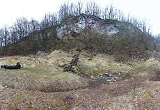
Eastern shrinkage of the Bauerngraben
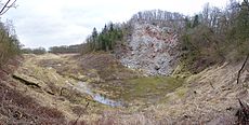
Remains of the episodic lake at the western shrinkage of the Bauerngraben
_08.jpg)
_04.jpg)
See also
Individual evidence
- ↑ a b Altitude location: Estimated value according to the referenced map services of the Federal Agency for Nature Conservation (BfN), because the Glasebach flows slightly above the lake at an altitude of 257.4 m
- ↑ a b Saxony-Anhalt viewer of the State Office for Surveying and Geoinformation ( notes )
- ↑ a b c d Map services of the Federal Agency for Nature Conservation ( information )
- ↑ a b c Der Bauerngraben , on karstwanderweg.de
- ↑ Harzer Wanderadel: stamp point 213 / Bauerngraben , on harzer-wandernadel.de
Web links
- Bauerngraben location , on karstwanderweg.de
- The Bauerngraben , on karstwanderweg.de
- The Bauerngraben near Roßla (private site), on mathias-online.de
- The Bauerngraben or Hungersee , Petermanns (geographical) Mittheilungen , 1864, pp. 43–46, on books.google.de
- Bauerngraben , excerpt from the Universal Lexikon , Volume 3, edited by Heinrich August Pierer, on google.books.de