Immenrode (Werther)
|
Immenrode
municipality Werther
Coordinates: 51 ° 29 ′ 58 ″ N , 10 ° 38 ′ 39 ″ E
|
|
|---|---|
| Height : | 209 m above sea level NN |
| Residents : | 120 |
| Incorporation : | January 1, 1997 |
| Postal code : | 99735 |
| Area code : | 036335 |
|
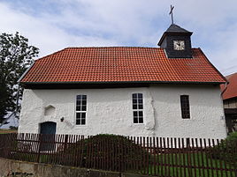
Village church
|
|
Immenrode and the associated hamlet of Fronderode are part of the Werther municipality in the Nordhausen district in Thuringia in Germany.
geography
Immenrode is located in the southern Harz foreland near the Südharz nature park , in the northern Thuringian hill country . In the "Südharz" natural landscape, north of the settlements of Immenrode and Fronderode, there is a chain of karst features. The "Steinsee" and the Großer Seeloch particularly characterize this landscape. The Haferbach , a right tributary of the Helmets, flows through the village .
history
The "Big Lake Hole" is seen as a prehistoric place of worship. The farming village of Immenrode was first mentioned in a document in June 1129.
With the dissolution of the Helmetal administrative association , the once independent municipality of Immenrode became part of the newly formed municipality of Werther on January 1st, 1997.
Web links
Individual evidence
- ↑ Michael Köhler: Pagan sanctuaries: pre-Christian places of worship and suspected cult sites in Thuringia . Jenzig-Verlag, Jena 2007, ISBN 978-3-910141-85-8 , pp. 125, 222 .
- ^ Wolfgang Kahl : First mention of Thuringian cities and villages - A manual . Verlag Rockstuhl, Bad Langensalza 2010, ISBN 978-3-86777-202-0 , p. 132 .

