
Haferbach (helmets)
| Haferbach | ||
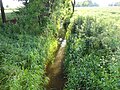
 The Haferbach near the Flarichsmühle |
||
| Data | ||
| Water code | DE : 564816 | |
| location | Werther municipality , Nordhausen district , Thuringia , Germany | |
| River system | Elbe | |
| Drain over | Helme → Unstrut → Saale → Elbe → North Sea | |
| source | several sources northeast of Kehmstedt 51 ° 29 ′ 9 ″ N , 10 ° 36 ′ 52 ″ E |
|
| Source height | approx. 250 m above sea level NN | |
| muzzle | east of the Flarichsmühle in the Helme coordinates: 51 ° 30 ′ 30 " N , 10 ° 41 ′ 35" E 51 ° 30 ′ 30 " N , 10 ° 41 ′ 35" E |
|
| Mouth height | 191 m above sea level NN | |
| Height difference | approx. 59 m | |
| Bottom slope | approx. 8.6 ‰ | |
| length | 6.9 km | |
| Left tributaries | Rolandsgraben | |
| Right tributaries | Schlerngraben | |
The Haferbach is a right tributary of the Helme in the municipality of Werther in the Nordhausen district in Thuringia .
course
The Haferbach rises from several small springs northeast of Kehmstedt . It then flows through the Fronderode district, which belongs to Immenrode . A few kilometers further on, he now reaches Immenrode. Here it continues to pick up smaller streams from the left. After Immenrode it flows after oats . Here, too, some small streams and the Rolandsgraben and later the Schlerngraben flow into it . The Haferbach flows past the Flarichsmühle and flows east of it into the Helme.
gallery
Haferbach just before the mouth

The mouth of the Haferbach (left) in the Helmets (right)


Web links
Commons : Haferbach - Collection of images, videos and audio files
Individual evidence
- ↑ Map from Google Earth