Teichbach (Wipper)
|
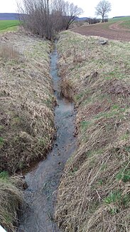
Teichbach upper course: Schluftergraben |
||
|
The pond stream near the hamlet of Hünstein |
||
| Data | ||
| Water code | DE : 564652 | |
| location | Municipalities of Großlohra and Bleicherode , Nordhausen district , Thuringia , Germany | |
| River system | Elbe | |
| Drain over | Wipper → Unstrut → Saale → Elbe → North Sea | |
| source | between Friedrichslohra and Großbaren on the western edge of the Hainleite 51 ° 25 ′ 6 ″ N , 10 ° 38 ′ 29 ″ E |
|
| Source height | approx. 318 m | |
| muzzle | south of Wollersleben in the Wipper coordinates: 51 ° 26 ′ 10 ″ N , 10 ° 43 ′ 17 ″ E 51 ° 26 ′ 10 ″ N , 10 ° 43 ′ 17 ″ E |
|
| Mouth height | approx. 209 m above sea level NN | |
| Height difference | approx. 109 m | |
| Bottom slope | approx. 17 ‰ | |
| length | about 6.6 km | |
| Right tributaries | nameless brook west of Hainrode, Hainröder Bach | |
| Communities | Großlohra , Bleicherode | |
The Teichbach , also called Schluftergraben in the upper reaches , is a 6.6 km long right tributary of the Wipper in the southern district of Nordhausen in northern Thuringia .
geography
The Teichbach rises as a Schluftergraben between the villages of Friedrichslohra and Großbaren on the northwestern edge of the Hainleite ridge . Shortly behind its source, it touches Münchenlohra with the famous St. Gangolf basilica . After about half of its flow, it touches the Teichmühle farmstead and changes its name to Teichbach . Further down the stream it reaches the hamlet of Hünstein , takes in the Hainröder stream and flows into the Unstrut tributary Wipper opposite the village of Wollersleben .
On some maps, its right tributary, the Hainröder Bach, is also referred to as the Teichbach. This has its sources namely in the specifically related recreation area Teichtal . The homestead and presumably former mill Teichmühle , however, refers to a specific connection with the actual Teichbach, which is called Schluftergraben in the upper reaches.
Web links
Individual evidence
- ↑ Map from Google Earth
