
Zorge (river)
| Concern | ||
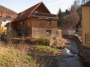
 The Zorge in Nordhausen |
||
| Data | ||
| Water code | DE : 56482 | |
| location | District of Göttingen and District of Nordhausen ; Lower Saxony and Thuringia ( Germany ) | |
| River system | Elbe | |
| Drain over | Helme → Unstrut → Saale → Elbe → North Sea | |
| source |
Great Wolfsbach in Hohegeiß 51 ° 40 ′ 33 ″ N , 10 ° 39 ′ 53 ″ E |
|
| Source height | approx. 569 m above sea level NHN | |
| muzzle | to Windehausen in the helmets coordinates: 51 ° 27 '9 " N , 10 ° 54' 11" E 51 ° 27 '9 " N , 10 ° 54' 11" E |
|
| Mouth height | 158.8 m above sea level NHN | |
| Height difference | approx. 410.2 m | |
| Bottom slope | approx. 10 ‰ | |
| length | 39.6 km | |
| Catchment area | 357 km² | |
| Discharge at the Nordhausen A Eo gauge : 304 km² Location: 11 km above the mouth |
NNQ (October 20, 1966) MNQ 1954–2014 MQ 1954–2014 Mq 1954–2014 MHQ 1954–2014 HHQ (March 4, 1956) |
50 l / s 348 l / s 3.52 m³ / s 11.6 l / (s km²) 41 m³ / s 95.1 m³ / s |
| Left tributaries | see below | |
| Right tributaries | see below | |
| Medium-sized cities | Nordhausen | |
| Small towns | Ellrich , herrings | |
| Communities | Zorge , Harz Gate , | |
The Zorge is a 39.6 km long, northwest and left tributary of the helmets in the Lower Saxony district of Göttingen and in the Thuringian district of Nordhausen . In many sources Zorge with wild river translated.
geography
course
The Zorge arises in Lower Saxony in the Harz Mountains and within the Harz Nature Park through the confluence of Wolfsbach and Sprakelbach in the village of Zorge in the middle of the upper part of the village at around 352 m above sea level. NHN . The Wolfsbach in turn has several source streams. The source of the Großer Wolfsbach has the longest flow path and is classified as the main source of the Zorge. It is just below 570 m above sea level. NHN at the sports field in Hohegeiß .
Initially the Zorge flows in a southerly direction and from around the Lower Saxony-Thuringia border into the southeast. In the Thuringian part of the Harz, it runs through the South Harz Nature Park . Here Ellrich , Woffleben and Cleysingen are on the river. On the southern edge of the nature park, the Zorge touches Niedersachswerfen , a district of Harztor . Then it flows through Nordhausen . After the city, the river passes Bielen and Windehausen .
A little more than 2 km behind Windehausen, the Zorge passes under the Halle – Hann railway line. Münden . Shortly afterwards, at 158.8 m above sea level, it flows into the Unstrut tributary Helme coming from the west or from the direction of Heringen . The estuary lies in the Kyffhäuser Nature Park .
Catchment area, source streams and tributaries
The catchment area of the Zorge is 357 km².
Source streams and tributaries lined up downstream and with orographic allocation (l = left-hand side, r = right-hand side) :
|
Main source:
Further source streams:
Tributaries: |
|
|
|
Hydrology and water quality
Along with other rivers such as the Wieda , the source brooks of the Zorge drain one of the areas with the highest rainfall in the Harz Mountains. The amount of water supplied to the helmets was one of the reasons for the construction of the Kelbra dam on this river . In Thuringia the Zorge is rated as “moderately polluted” ( water quality class 2). In the late summer of 2019, the river dried up completely due to the lack of precipitation from the south-eastern outskirts of Nordhausen to Bielen. Numerous fish as well as other organisms living in the water perished. The local fishing club rescued some animals from the remaining puddles.
photos
Sprakelbach (l) and Wolfsbach (r) form the Zorge in Zorge

the Zorge in Ellrich

The worry at Woffleben

the Zorge in Nordhausen


Individual evidence
- ↑ Lower Saxony environmental cards with AK5 , on Umweltkarten-niedersachsen.de
- ↑ a b Map services of the Federal Agency for Nature Conservation ( information )
- ↑ a b The Zorge from the source of the Großer Wolfsbach to the Helme as a drawn GPS track , on gpsies.com
- ↑ a b Complete list of rivers in the Elbe catchment area (updated on July 13, 2010), on Umwelt.niedersachsen.de (PDF; 365.48 KB)
- ^ German Hydrological Yearbook Elbe Region, Part I 2014. (PDF) State Office for Flood Protection and Water Management Saxony-Anhalt, p. 183 , accessed on November 3, 2018 (from: lhw.sachsen-anhalt.de).
- ↑ Water quality, flowing waters 2006 , on tlug-jena.de (PDF; 412.8 kB)