
Bere (worry)
|
Bere Behre (frequent misspellings) |
||
 The Bere with level stick at the new level measuring station north of Ilfeld |
||
| Data | ||
| location | Thuringia , Saxony-Anhalt ; Germany | |
| River system | Elbe | |
| Drain over | Zorge → Helme → Unstrut → Saale → Elbe → North Sea | |
| source | at Birkenkopf at Ilfeld -Birkenmoor 51 ° 36 '30 " N , 10 ° 53' 24" O |
|
| Source height | 530 m above sea level NN | |
| muzzle | in Niedersachswerfen in the Zorge coordinates: 51 ° 32 ′ 45 ″ N , 10 ° 45 ′ 21 ″ E 51 ° 32 ′ 45 ″ N , 10 ° 45 ′ 21 ″ E |
|
| Mouth height | 205.5 m above sea level NN | |
| Height difference | 324.5 m | |
| Bottom slope | about 17 ‰ | |
| length | about 19.5 km | |
| Discharge at the Ilfeld A Eo gauge : 62.3 km² Location: 7 km above the mouth |
NNQ (07/11/1976) MNQ 1952–2014 MQ 1952–2014 Mq 1952–2014 MHQ 1952–2014 HHQ (12/19/1965) |
10 l / s 72 l / s 912 l / s 14.6 l / (s km²) 13.3 m³ / s 57.5 m³ / s |
| Left tributaries | Big Merkelsbach, Little Merkelsbach, Brandesbach | |
| Right tributaries | Tiefenbach , Schuppenbach , Leimbach , Fuhrbach | |
| Communities | Harztor , Oberharz am Brocken | |
The Bere is an approximately 19.5 km long, left and northeastern tributary of the Zorge in the southern Harz in Thuringia and Saxony-Anhalt .
Often - also on hiking maps available in stores - there is a misspelling as a warning.
course
The Bere rises halfway between Birkenmoor and Breitenstein . Its source lies between the Birkenkopf ( 599.8 m ), the Gillenkopf 558.2 m and the Große Harzhöhe ( 599.3 m ) and has tributaries close to the source from the neighboring Schalliete ( 595.1 m ) and upstream tributaries from the Leckenkopf ( 546, 9 m ) and middle course tributaries , including from Poppenberg ( 600.6 m ).
Shortly after its source to about the Eisfelder Talmühle train station , the Bere forms the border stream between Saxony-Anhalt and Thuringia. It flows along the Selketalbahn , from Eisfelder Talmühle station along the Harzquerbahn , then past the Rabensteiner tunnels - in Netzkater - and through Ilfeld . Finally, the Bere flows into the Helme tributary Zorge in Lower Saxony .
Water quality
The upper reaches of the Bere are rated as lightly polluted ( water quality class I – II), the middle and lower reaches as moderately polluted (water quality class II).
Picture gallery
The images are arranged downstream.

The Bere with the level staff seen from the new bridge
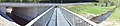
The new level measuring station and bridge of the B 4 over the Bere
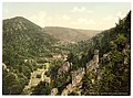
The Beretal near Ilfeld, around 1900


Individual evidence
- ↑ a b measured with Google Earth
- ^ German Hydrological Yearbook Elbe Region, Part I 2014. (PDF) State Office for Flood Protection and Water Management Saxony-Anhalt, p. 184 , accessed on November 3, 2018 (from: lhw.sachsen-anhalt.de).
- ↑ For example: ADAC hiking guide Harz. ISBN 978-3-89905-729-4 or on the Internet at www.harzlife.de
- ↑ http://www.tlug-jena.de/uw_raum/umweltregional/thueringen/maps/gewaesserguete_06.pdf
literature
- Hiking in the Harz Mountains. (Sheet WL18) Hiking maps 1: 50,000, Landesvermessungsamt Niedersachsen / Landesvermessungsamt Sachsen-Anhalt, ISBN 978-3-89435-669-9 .