
Salza (helmets)
| Salza | ||
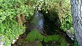
 The Salza just behind its source. |
||
| Data | ||
| Water code | DE : 5648176 | |
| location | City of Nordhausen , Nordhausen district , Thuringia , Germany | |
| River system | Elbe | |
| Drain over | Helme → Unstrut → Saale → Elbe → North Sea | |
| source |
Salzaspring near Nordhausen 51 ° 31 ′ 48 ″ N , 10 ° 45 ′ 44 ″ E |
|
| Spring discharge |
MQ |
704 l / s |
| muzzle | in Niedersalza in the Helme coordinates: 51 ° 29 ′ 7 ″ N , 10 ° 46 ′ 7 ″ E 51 ° 29 ′ 7 ″ N , 10 ° 46 ′ 7 ″ E
|
|
| length | about 5.6 km | |
| Medium-sized cities | Nordhausen-Salza | |
The Salza is a 5.6 km long left tributary of the Helme in Nordhausen in Thuringia in Germany.
course
The Salza rises from the Salzaspring , the largest karst spring in Thuringia. It runs parallel to the Zorge through the northern part of Salza . It used to be dammed several times in the urban area and drove some mills. Today there are only a few weirs left in the Salza. One of them directs part of its very clear water to a fish farm. After a good 5.6 km run, the Salza flows into the helmets.
Picture gallery
The Salza in the northern part of Salza, at the North Thuringian workshops, formerly Lebenshilfe downstream and:
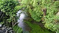
-upstream

The Salza in the Nordhausen district of Salza, near the primary school
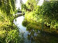
The Salza in the Nordhausen district of Salza, near the primary school


