Salza (Nordhausen)
|
Salza
City of Nordhausen
Coordinates: 51 ° 31 ′ 2 ″ N , 10 ° 46 ′ 9 ″ E
|
|
|---|---|
| Height : | 190 m above sea level NN |
| Incorporation : | July 1, 1950 |
| Postal code : | 99734 |
| Area code : | 03631 |
|
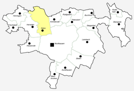
Location of Salza in Nordhausen
|
|
|
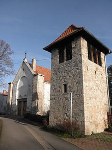
Church in Salza
|
|
Salza is a district in the north of the city of Nordhausen in Thuringia .
geography
The district of Salza is located on the northwestern edge of the core town of Nordhausen. The place extends along the Südharzbahn Nordhausen - Northeim and divides into the old village west of the station and a newer part east of it. The Salza flows through Salza . It rises not far from the district in the largest karst spring in Thuringia, the Salzaspring . To the east of the district, Bundesstraße 4 runs to Ilfeld and further. To the south-west is the federal highway 243 and the federal highway 38 with a connection at Werther . In the north is the Obersalza settlement , in the south Niedersalza .
history
Salza was first mentioned in a document on September 15, 802.
On the mountain spur "Birkenkopf" from the foothills of the Kohnstein massif there are walls lying one behind the other. All three walls probably protected a hill fort from the late Bronze Age and Iron Age.
Around 780 a Frankish settlement was established on the eastern bank of the Salza . At that time there was probably already an older Thuringian settlement on the western bank.
The first school in Salza was built in 1822 in Kirchstrasse 10, and a second in 1864 in Teichstrasse. In 1904 the community received a train station.
The estate, which was managed as a domain, had a usable area of 158 hectares in 1923, after 1945 the operation was transferred to a state-owned estate .
Salza has belonged to the area of the city of Nordhausen since July 1, 1950 and therefore has no local council or district mayor.
Sports
The soccer section of the company sports association BSG Motor Süd Nordhausen played in the regional soccer class of Thuringia from 1948 to 1952 .
Attractions
- The Protestant Church of St. Laurentius with a bell tower
- The Salzaspring , the largest karst spring in Thuringia
Personalities
Sons and daughters of Salza
- Erich Peter (1919–1987), military, Colonel General of the NVA and longstanding head of the GDR's border troops
- Gerhard Arnhardt (1936–2008), educator and university professor
Persons connected to Salza
- Robert Otto (1902–1986), architect, recipient of the Federal Cross of Merit 1st Class (1967), grew up in Salza.
- Josef Tauchmann (1920–2009), geography teacher at the Albert Kuntz High School Salza (1948–1985), hobby meteorologist. Recorded the weather in Nordhausen-Salza for over 50 years.
literature
- Steffen Iffland (Hrsg.): History of the 1200 year old village Salza near Nordhausen am Harz (= The Heimatbote . Issue 6). Nordhausen 2002, ISBN 3-9807032-6-6 .
Web links
- Timeline and short chronicle of Salza near Nordhausen am Harz on nordhausen-salza.de
- Salza on nordhausen-wiki.de
- "Schurzfell" settlement on nordhausen-wiki.de
Individual evidence
- ↑ Official topographic maps of Thuringia 1: 10,000. Eichsfeldkreis, LK Nordhausen, Kyffhäuserkreis, Unstrut-Hainich-Kreis . In: Thuringian Land Survey Office (Hrsg.): CD-ROM series Top10 . CD 1. Erfurt 1999.
- ^ Wolfgang Kahl : First mention of Thuringian towns and villages. Rockstuhl Verlag, Bad-Langensalza 2010, ISBN 978-3-86777-202-0 , p. 245.
- ↑ Michael Köhler: Thuringian castles and fortified prehistoric and early historical living spaces. Jenzig-Verlag, Jena 2001, ISBN 3-910141-43-9 , p. 67.
- ^ Jürgen Gruhle: Land Reform Black Book. 2011, accessed on May 20, 2011 (overview by federal states and locations on expropriation measures after the end of World War II as part of the land reform).
- ^ Steffen Iffland: From Salza carpenter to architect . nnz-online.de, January 5, 2010, accessed on January 23, 2013.


