
Sundhausen (Nordhausen)
|
Sundhausen
City of Nordhausen
|
|
|---|---|
 |
|
| Height : | 175 m above sea level NN |
| Incorporation : | July 1, 1994 |
| Postal code : | 99734 |
| Area code : | 03631 |
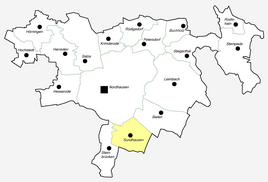  Location of Sundhausen in Nordhausen
|
|
_Kirche.JPG) Church of St. Laurentius in Sundhausen
|
|
_Schloss.JPG)
Sundhausen is a rural district on the banks of the Helme in the south of the city of Nordhausen in Thuringia .
location
Sundhausen is located south of the former city limits of Nordhausen, north of the federal motorway 38 at the Nordhausen junction and on the federal road 4 Nordhausen- Erfurt . The district is located in the Helmemiederung and in the transition to the ridge of the Windleite .
history
Sundhausen was first mentioned in a document on January 31, 983.
A small medieval low castle stood on the site of the current manor house. The castle was the seat of the Reichsministerial von Sundhausen. The majority of the farm buildings formed the area of a bailey. Sparse remains of the former fortifications can still be seen. To the west of the Sundhausen district is the Kesselberg , a prominent elevation about one kilometer from the town on the edge of the Helmeniederung. Archaeological finds from different periods of the Neolithic and the early Middle Ages come from there. A proven wall that protected the spur-like ridge of the terrain dates from the urnfield period .
Instead of a very old Laurentius Church, the current church, including a new tower, was built from 1785 to 1800. In 1923 a war memorial was erected next to the church from a granite block from the Harz for the fallen and missing 40 participants in the First World War. In 1945 the Iron Cross had to be removed; the monument fell into disrepair during the GDR era.
From the 1930s to 1945 there was an air base between the village and Helme.
Sundhausen had to witness the destruction of neighboring Nordhausen by the British Royal Air Force on April 3 and 4, 1945. A few days later it was occupied by US troops, who were replaced by the Red Army in early July. Sundhausen became part of the Soviet Zone and from 1949 the GDR. It was accordingly affected by expropriations and the forced collectivization of agriculture.
The manor house called Carlsburg , the administration building and part of the farm buildings of the former manor (former Schreibersches Gut) have been preserved. There had been a total of six estates in Sundhausen.
In the vicinity of the village, gravel and sand were extracted from the bottom of the Helme valley after the war for the needs of the regional construction industry. What remained was the Sundhäuser lake and other quarry ponds , which today u. a. can be used as diving waters , developed through two diving centers. For example, divers can use several wrecks and a. the underwater city of Nordhusia with Germany's first underwater church can be visited.
The BAB 38 leads in a wide arc around the town in the south.
Sons and daughters of the church
- Hugo Haase (1902–1966), hydrologist
Web links
Individual evidence
- ↑ a b Official topographic maps of Thuringia 1: 10,000. Eichsfeldkreis, LK Nordhausen, Kyffhäuserkreis, Unstrut-Hainich-Kreis . In: Thuringian Land Survey Office (Hrsg.): CD-ROM series Top10 . CD 1. Erfurt 1999.
- ^ Wolfgang Kahl : First mention of Thuringian cities and villages - A manual . Verlag Rockstuhl, Bad Langensalza 2010, ISBN 978-3-86777-202-0 , p. 279 .
- ↑ Michael Köhler: Thuringian castles and fortified prehistoric and early historical living spaces . Jenzig-Verlag, Jena 2001, ISBN 3-910141-43-9 , p. 79, 155 .

Districts:
Bielen |
Buchholz |
Talk |
Hesserode |
Hochstedt |
Hörningen |
Leimbach |
Petersdorf |
Rodishain |
Steigerthal |
Stone bridges |
Stempeda |
Sundhausen
districts:
Krimderode |
Nordhausen |
Rüdigsdorf |
Salza