
Talk
|
Talk
City of Nordhausen
Coordinates: 51 ° 31 ′ 10 ″ N , 10 ° 44 ′ 20 ″ E
|
|
|---|---|
| Height : | 208 m above sea level NN |
| Residents : | 590 |
| Incorporation : | July 1, 1994 |
| Postal code : | 99734 |
| Area code : | 03631 |
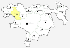  Location of Herreden in Nordhausen
|
|
 Church in Herreden
|
|
Herreden and the formerly associated district Hochstedt are districts of the city of Nordhausen in Thuringia . Hochstedt has been an independent district of Nordhausen since 2009.
geography
Herreden is located about four kilometers northwest of the city of Nordhausen in a rural area. Your district borders on the original city limits. The federal motorway 38 passes immediately to the south . The connection point is at Werther .
Waters
The Herreder Bach flows through Herreden . Its source area is south of the town of Hörningen . At Hesserode it ends in the helmets .
history
The large lake hole natural monument is part of a chain of karst phenomena in the communal corridor, the roughly circular, water-filled sinkhole has a diameter of about 110 meters. This sight, located south of Hochstedt, probably also had a regional significance as a prehistoric place of worship . The current village of Herreden was first mentioned in 1206 and the village of Hochstedt on November 4, 1184.
On July 1, 1950, the previously independent communities Hochstedt and Hörningen were incorporated.
church
Individual evidence
- ↑ Michael Köhler: Pagan sanctuaries: pre-Christian places of worship and suspected cult sites in Thuringia . Jenzig-Verlag, Jena 2007, ISBN 978-3-910141-85-8 , pp. 76 .
- ↑ Wolfgang Kahl : First mention of Thuringian cities and villages , Rockstuhl Publishing House, Bad-Langensalza 2010, ISBN 978-3-86777-202-0 , p. 120.
Web links

Districts:
Bielen |
Buchholz |
Talk |
Hesserode |
Hochstedt |
Hörningen |
Leimbach |
Petersdorf |
Rodishain |
Steigerthal |
Stone bridges |
Stempeda |
Sundhausen
districts:
Krimderode |
Nordhausen |
Rüdigsdorf |
Salza