
Kelbra (Kyffhauser)
| coat of arms | Germany map | |
|---|---|---|

|
Coordinates: 51 ° 26 ' N , 11 ° 2' E |
|
| Basic data | ||
| State : | Saxony-Anhalt | |
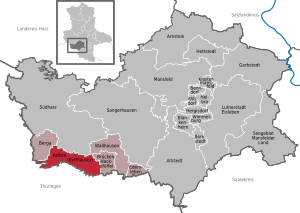
| County : | Mansfeld-Südharz | |
| Association municipality : | Golden floodplain | |
| Height : | 157 m above sea level NHN | |
| Area : | 40.55 km 2 | |
| Residents: | 3335 (Dec. 31, 2019) | |
| Population density : | 82 inhabitants per km 2 | |
| Postal code : | 06537 | |
| Area code : | 034651 | |
| License plate : | MSH, EIL, HET, ML, SGH | |
| Community key : | 15 0 87 250 | |
| LOCODE : | DE K77 | |
| Address of the rural city administration: |
Lange Strasse 8 06537 Kelbra (Kyffhäuser) |
|
| Website : | ||
| Mayor : | Lothar Bornkessel | |
| Location of the rural town of Kelbra (Kyffhäuser) in the district of Mansfeld-Südharz | ||
  |
||


Kelbra (Kyffhäuser) is a country town in the association community Goldene Aue in the district of Mansfeld-Südharz in the Thuringian part of Saxony-Anhalt .
geography
location
Kelbra is located to the right (south) of the Helme , on the western part of the northern slope of the Kyffhäuser Mountains in the Golden Aue , directly on the federal road 85 ( Bier- und Burgenstraße ). In the immediate vicinity to the south and west of the city, the districts of Mansfeld-Südharz meet with the Kyffhäuserkreis and about 3.5 km west of the city also with the district of Nordhausen .
Neighboring communities
Surrounding localities are in the north Berga (Kyffhäuser) (with a common border) and Thürungen , which is incorporated into Kelbra , in the northeast Roßla (common border) in the east the incorporated localities Sittendorf and Tilleda . In the south is the village of Steinthaleben , (common border in the south and southeast), to which large parts of the Kyffhäuser Mountains , including the Rothenburg located southeast directly above the city, belong. The Kyffhausen Imperial Castle with the Kyffhäuser monument , a little further east above Sittendorf and Tilledas, is also located within this municipality. The next localities in the southeast are the somewhat more distant places Udersleben and the city Bad Frankenhausen , which are located on the other side of the Kyffhäuser Mountains, to which there is no common border. In the southwest is Badra , again with a shared municipal border. In the west the European village of Auleben (with a common border) and Numburg, which belongs to Badra , in the northwest is the next village Görsbach , to which there is again no common border, in between Auleben and Berga have their common border
City structure
The districts of Sittendorf , Thürungen and Tilleda now belong to Kelbra . Altendorf, once an independent village to the west of the former city wall, was incorporated as early as the 19th century and is part of the immediate urban area. The outer area of the city also includes the deserted areas of Ramderode (located on the Hernsgenberg between Kelbra and Roßla), Lindeschu and Nauritz (the latter two on the Siechengraben between Kelbra and Sittendorf), Topfstedt (located immediately south of Bergas on the Thyra), Hirschbach ( north of Tilleda) and Steden (east of Tilleda on the Kleine Helme or Wolweda)
tourism
Due to its location at the Kelbra dam and its proximity to Kyffhäuser, the city has become a tourist center, but it also suffers from the heavy excursion traffic, as the Kyffhäuser rise, which is particularly attractive for motorcyclists , begins here. Car races were held here regularly until 2009 ( Kyffhäuser racetrack ).
- Reservoir
The reservoir of the Kelbra dam with the renatured marshland adjoining it to the west has been an internationally important refuge for birds under the protection of the Ramsar Convention (Ramsar Convention Area 176) since 1978 . At the same time, however, it is one of the most important tourist destinations in the summer months. On the south coast of the lake there are three beach baths filled with sand: for nudists, as a textile beach, and as a textile beach in the campsite; all with good service, restaurant, ambulance service and lawn. There is also a large campsite with its own lido. In addition, there is a marina for sailing and rowing boats with an associated dock, maintenance hall and boat rental. Motor boats are forbidden and only used for the rescue service. In addition, the reservoir also serves to protect the densely populated middle and lower Golden Aue from flooding and as a water reservoir for dry years for agriculture and to guarantee minimum ecological runoff.
- Kyffhäuser, Goldene Aue and the surrounding area
The cave systems of the Barbarossa Cave , the Heimkehle and the not yet accessible Numburg Cave are located in the vicinity of Kelbra . The same goes for the Kyffhäuser Monument and the old Kyffhausen Castle with the deepest well in Germany, 176 m deep. Furthermore , the Rothenburg located directly above the city , the nearby cities of Bad Frankenhausen with the Peasants' War panorama , Hausmannsturm , castle with regional museum and above all the leaning upper church ; the historic European city of Stolberg with the castle of the former county of Stolberg ; also Sondershausen with the castle of the county of Schwarzburg-Sondershausen , Sangerhausen with its Europa-Rosarium , Heringen with its castle of the county of Hohnstein - Heringen and the former imperial city of Nordhausen . Also worth seeing are the European village of Auleben , the Palatinate Tilleda , and above all the many well-preserved half-timbered villages around the Kyffhäuser Mountains and in the Golden Aue, which can be discovered on foot or by bike.
Kelbra is also a good starting point for excursions into the Harz Mountains . and to the nearby southern Harz foreland ( southern Harz karst landscape , southern Harz nature reserve , southern Harz Zechstein belt ) and the other smaller mountain ranges in the vicinity: Windleite , Hainleite , Schmücke , Hohe Schrecke and Finne .
- Kyffhäuser Nature Park
The near-natural mixed forests of the Kyffhäuser Nature Park, immediately south of the city, are ideal for hiking, as are the old orchards with apples, pears, plums and, above all, cherries , located in and near the nature park . They are particularly attractive in spring when the cherry blossoms are in bloom , but also in summer when the cherry is harvested. They can be found both in Kelbra and in the immediate vicinity of Tilleda , Sittendorf (both to the east), Steinthaleben (south), Badra (south-west), Auleben and Hamma (both to the west).
The neighboring village of Thürungen , located in the middle of the Golden Aue, was and is the center of vegetable cultivation, thanks to the most fertile meadows and centuries of experience of its inhabitants.
From the mountains of the Kyffhäuser Mountains you have a wide view to the north over the Goldene Aue to the Harz, or to the south over the Diamantene Aue to the Hainleite , Schmücke and Hohe Schrecke . From the Kulpenberg television tower you can see the Großer Inselsberg in the Thuringian Forest over the Hainleite . To the west, the Kyffhäuser Mountains flow over the Numburg Mountains into the equally wooded Windleite .
Kyffhäuser Geopark
The Kyffhäuser Geopark was founded around the Kyffhäuser Mountains in 2005 with an area of around 833 km², to which the town of Kelbra also belongs, which includes both the nature park and the nature reserves.
- Nature reserves
Close by are the nature reserves Rothenburg and Schlossberg-Solwiesen, which have been merged since 2004 to form the Natura 2000 area Kyffhäuser-Badraer Schweiz-Solwiesen (BfN ID 4632-302, WDPA-ID 555519959, DE4632302 and 33.28 km² in size) divided into 4 parts: (a) the entire north of the Kyffhäuser Mountains between the Wolwedatal near Tilleda to the Altendorfer Klippen near Kelbra, including the entire Kyffhäuserberg, Rothenburgberg and Altendorfer Klippen; (b) the Zechstein limestone and gypsum areas in the south and west of the Kyffhäuser Mountains between Ichstedt ( Ichstedter Lehde ), Udersleben , Bad Frankenhausen, Rottleben and Steinthaleben, including the Eller near Badra (c) the Numburg mountains and (d) the Solwiesen in the floodplain between Numburg and Auleben, including the Numburg Bay of the Kelbra reservoir, the latter forming part of the above-mentioned Ramsar area 176.
dialect
In Kelbra, “Gallewersch” (Kelbraerisch) or “Uhlnderfsch” (Altendorfsch) is (was) spoken, a separate variant of the North Thuringian dialect , which is also spoken in the immediate neighboring towns in the middle Golden Aue and around the “Kipphieser” (Kyffhäuser Mountains) (became), unfortunately the original dialect has been lost with the generations that have already grown up due to constant disdain in schools and the public.
history
Beginnings
Kelbra was first mentioned in 1093 as Chelvera. It was located in the central-southern part of the old Thuringian Helmegau.
In the 11th century, parts of the Helmeried came to the Archdiocese of Mainz and the Fulda Monastery . The Walkenried monastery acquired the area around Görsbach around 1144 . Later meliorierten the monks with the resident Flemings the country between Görsbach and Kelbra and further down. They were experienced and brought money, livestock and crops with them from their homeland. Despite the drainage, there were always water problems. The Goldene Aue was a single lake on February 8th and 9th, 1946. The water stood from Heringen to Ritteburg and the Thyratal . The past high water levels were carved into the southern abutment of the Mühltalgrabenbrücke in Kelbra. The highest water level was in 1881 and 1946 with over 4 meters.
Rothenburger (1101–1223) and Beichlinger (1223–1348)
In 1103 or 1101 the counts, later named after Rothenburg , inherited the same castle and large estates in the Golden Aue, including Kelbra. In 1223 Count Cristian von der Rothenburg died childless and bequeathed the castle and property to the Counts of Beichlingen . In 1251, Count Friedrich von Beichlingen founded the Cistercian convent Kelbra , which was consecrated to Saint George , as well as the town church that still exists today and was once part of this monastery. The Arnswaldtisch knight's seat was also built during this time . At the request of Count Friedrich von Beichlingen, Bishop Peter von Mainz raised the Wenzelskirche in Kelbra to a parish church again on July 31, 1308 . This church once stood at the Seigertor, roughly at the site of today's Kautzleben bakery. It is believed that it was the first church in the city of Kelbra.
Hohnsteiner (1348-1413)
Around the year 1348 the Counts Heinrich II. And Gerhard III. von Rothenburg passed most of their county, including Kelbra, to the Counts of Hohnstein . The town charter was given to Kelbra, already owned by the Hohnsteiner, in 1351. The Counts of Hohnstein no longer lived in Rothenburg, but already in Kelbra Castle (moated castle) or Storkeyer Hof. Until 1413, Kelbra was the seat of the Hohnstein – Kelbra line.
Stolberger, Schwarzburger and Wettiner (1413–1806)
After the end of the Flegler War and the Heldrunger feud on January 8th, 1413, Count Heinrich von Hohnstein was given by Landgraves Friedrich IV. , Wilhelm II. And Friedrich the Elder. J. von Thuringia left the castles and cities of Heldrungen and Wiehe . In return, he had to cede his claims to Kelbra, Harzgerode , Güntersberge , Hoym , Ballenstedt and Sandersleben . However, the Wettins, who had achieved a decisive position of power in the Golden Aue as early as the 14th century due to their strength, did not set up their own administration in Kelbra, but instead relocated the town, which is on the periphery of their own possessions, along with the castle and accessories to seemingly reliable pledges . They believed they had found this in the Counts of Schwarzburg and zu Stolberg.
On, or immediately before August 3, 1413, the deposit of “sloß Kelbra, hus unde stadt mit dorffern, ackern” and all accessories for 12,500 Rhenish guilders and 160 Marks of Erfurt silver currency to the brothers Heinrich and Botho took place for three years to Stolberg . After the three-year period had expired, the Landgraves of Thuringia renewed the pledge of the castle and town of Kelbra along with accessories on February 6, 1417. This time the pledgee were Count Botho zu Stolberg and Count Heinrich von Wernigerode . A period of six years was set and the text of the contract included the clause that in the event of war the Counts should provide assistance to the Wettins. Due to a debt of Count Botho zu Stolberg and Heinrich von Wernigerode in the amount of 973 marks of silver Erfurt currency, which their uncle Count Heinrich von Schwarzburg took from them, they promised him on December 6, 1418 that they would leave half of the deposit amount, if the Wettins would redeem the city and the Kelbra office . The Wettins were not interested in such redemption in the years that followed. Therefore, the two counts of Stolberg and von Schwarzburg asked the dukes Friedrich and Sigismund of Saxony to give them Kelbra as a joint loan. The feudal letter issued as a result dated September 19, 1428.
On March 23, 1461, Duke Wilhelm of Saxony enfeoffed Metze, the wife of his Privy Councilor, Count Heinrich zu Stolberg, with half of the Kelbra Castle as personal property . In 1478 the Count of Stolberg left this half as pledge to the bailiff Ritter Hans Knauth .
The towns and offices of Kelbra and Heringen were practically jointly owned by the Counts and later Princes of Schwarzburg and the Counts of Stolberg from 1413 to 1806 , but were under the sovereignty of the Wettins . After the division of Leipzig in 1485 it came under their line of Albertines and thus from 1547-1806 to the Electorate of Saxony . Also the pledgee: at the house of Schwarzburg it was from 1560 to 1598 the line Schwarzburg-Frankenhausen , from 1598 to 1806 the line Schwarzburg-Rudolstadt Unterherrschaft Frankenhausen . When the county of Stolberg was divided into Stolberg-Stolberg and Stolberg Rossla on July 19, 1706, half of the two offices came to the Stolberg- Roßla line .
Napoleonic period (1806-1815)
With the creation of the Rhine Confederation in 1806, the Kingdom of Westphalia (1807) and the creation of the Kingdom of Saxony (1806), thanks to an alliance between the Electorate of Saxony and Napoleon, Kelbra was part of the Rhine Confederation and under the control of Napoleon. On the historical maps from this time it can be seen that Kelbra was neither in the Kingdom of Westphalia nor in the Kingdom of Saxony, but very close to them and within the Rhine Confederation, which Schwarzburg and Stolberg had also joined by 1808 at the latest.
Prussian Province of Saxony (1815-1945)
After the victory over Napoleon, there was the Congress of Vienna (1814–15), where the great victorious states served themselves with plenty of territories. Prussia annexed not only large areas of the Kingdom of Saxony, but also independent cities, spiritual territories and small states of Thuringia, Hesse and the Rhineland until then; here in the area of the Golden Aue the county of Stolberg, the free imperial city of Nordhausen and the offices of Heringen and Kelbra, which were previously under joint Blackburg and Stolberg rule. All former Saxon and Thuringian annexations were combined in the newly created Prussian province of Saxony . Both offices together with the entire county of Stolberg and thus also the city of Kelbra came to the administrative district of Merseburg and there to the district of Sangerhausen (province of Saxony) , while the county of Schwarzburg received compensation from Prussia for the loss of both offices.
First World War (1914-18)
121 Kelbra men were killed in the First World War.
The construction and completion of the Kyffhäuser Kleinbahn coincided with the First World War. Kyffhäuser Kleinbahn AG was founded in 1913. In the spring of 1914, shortly before the outbreak of war, the construction of the road began. It went into regular operation on the entire route between Berga and Artern from December 21, 1916. This route connected the town of Kelbra directly to the railway network. On June 5, 1966, operations were stopped because of the general poor condition of the track bed, which had caused the fall of a locomotive from the bridge over the mill ditch of the Helme near Kelbra. The track bed was not built from crushed stone, but consisted mostly of gravel. This came mainly from the Hackpfüffeler Heide, which was located directly on the route and was therefore cheaper to build.
Second World War (1939–1945)
Since autumn 1944 the hall of the restaurant "Zur Sängerhalle" was used as a prison camp. Hungarian SS soldiers guarded the prisoners. They had to work in the old brewery . A branch of the Mittelbau-Dora concentration camp was located there . Many of the prisoners were also killed in the bombing raids on Kelbra in April 1945. In early April the prisoners were sent on a march. They were only released at Ludwigslust . The camp in the old brewery was set on fire at the beginning of April 1945 and then plundered by the population.
On April 11, 14 US bombs hit Kelbra. They caused considerable damage to buildings. 12 people died, including 10 foreigners.
American tanks entered Kelbra on April 12, 1945. They came from the direction of Badra / Sondershausen. White sheets hung on some of the windows. Only the then mayor Rudolf Haake wanted to fight. He shot the soldiers with a pistol from his study in the town hall, injuring two Americans. He then apparently shot himself.
With the approach of the American troops, blast holes were prepared in the bridges, in the Hopfental a road block was built from old plows. The headquarters of the Volkssturm was in the Ratskeller, where weapons and bazookas were also stored.
At the beginning of July 1945, Soviet troops took command.
Incorporations
Already at the end of the 19th century, Altendorf, located directly in front of the city wall, was incorporated. Thürungen was added in 1972 and Sittendorf followed in 1974 .
On July 1, 2009, the previously independent community of Tilleda (Kyffhäuser), 7 km away, was also incorporated into Kelbra.
politics
Municipal council
The Kelbra municipal council has 16 members, who are distributed as follows after the local elections on June 7, 2009:
The CDU parliamentary group has four members, three members each from the SPD , FDP and the Free Voters , three other members are non-attached.
The 2014 local elections gave this result:
- SPD: 4 seats
- CDU: 3 seats
- Free community of voters: 2 seats
- Citizens' Initiative Sport and School Kelbra: 1 seat
- The left: 1 seat
- FDP: 1 seat
- non-attached: 2 seats
- Total: 14 seats
mayor
- Bruno Thiem (1823–1913) was Mayor Kelbras for ten years.
In September 2010, Lothar Bornkessel was elected mayor in the second ballot. The predecessor was Reinhard Teschke.
Lothar Bornkessel was re-elected in the last mayoral election (2017).
coat of arms
Blazon : "A silver calf in red on a curved green shield base."
The colors of the municipality are derived from the white-red coat of arms.
Town twinning
The twin towns of Kelbra are Bad Salzdetfurth in Lower Saxony , Frampton Cotterell in the English county of South Gloucestershire and Raduň (Opava district) in the Czech Republic.
Attractions
Buildings and monuments
- The town hall in its current form was built in 1777. The northern extension dates from the Renaissance period . A renovation took place in 2003 and 2004.
- The local museum is housed in the oldest house in Kelbra.
- Parts of the former castle have been preserved in the north of the city: the keep with palace ruins from the 12th century. In addition, there are remains of the curtain wall, a medieval city wall. The Counts of Hohnstein-Kelbra resided here.
- Remains of the Cistercian monastery have been preserved in Thomas-Müntzer-Straße . The monastery was donated by the Count von Beichlingen in 1251 and destroyed in 1525.
- The town church of St. Georgii is a former monastery church that was largely rebuilt in 1607. Its oldest parts date from the time the monastery was founded in the 13th century. Kyffhauser sandstone was used as building material.
- The church of St. Martini in the Altendorf district was probably built in the 11th century as a Romanesque fortified church. A renovation took place in 1357. Kyffhauser sandstone was also used here, the gable of the nave shows half-timbered houses.
- A house on the eaves with two cantilevered half-timbered upper floors on Thomas-Müntzer-Strasse houses the Schmidtsche Foundation. The foundation served to accommodate and care for poor children.
- The buildings of the former Kelbra brewery , Jochstraße 13, with the restored chimney from 1869 are an example of industrial architecture from the early days . The Kelbraer beer and the Kyffhäuser Pilsner were brewed here until 1926/27 . Between 1943 and 1945 the prisoners of the Kelbra satellite camp of the Mittelbau-Dora concentration camp who were imprisoned in the “Sängerhalle” restaurant worked in the cellars .
- Burial in the local cemetery for a particularly well-known Polish woman and her two-year toddler during the Second World War deported to Germany and victims of forced labor were
- The large Otto Hermann monument (built in 1909) consists of petrified wood and is located in the church valley; a smaller monument made of petrified wood stands opposite the Hotel Kaiserhof and is dedicated to Eduard Joch .
Natural monuments
- Klosterlinde
The "millennial" linden tree ( referred to as "church linden tree" in the list of monuments ) is in the churchyard of St. Georgii Church, the former cloister courtyard of the Cistersian monastery. Already when the monastery was founded in 1251 it was mentioned as "Old Linden Tree" and integrated into the complex. The linden tree suffered a lot in the “Great Fire” of 1607, but ultimately survived. In 1988 a thick branch broke off the tree due to the load of ice. The summer linden tree, designated as a natural monument (ND0032SGH), is at least 750 years old, but probably much older.
gallery

Kelbra Town Hall

Schmidt Foundation

Burg Primary School

Grabenstrasse


Keep
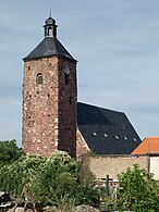
St. Georgii

Klosterlinde

St. Martini


_01.jpg)

traffic
In Berga there is also the Berga-Kelbra train station on the Halle – Kassel railway line, from where there are regular trains to Halle (Saale) and Kassel , ie there are also good connections to the nearby district towns of Nordhausen and Sangerhausen , as well as public transport Bus service to the main trains between Kelbra and Berga train station. There is also public bus transport to the district town of Sangerhausen , about 20 km away , which can also be reached via the above-mentioned railway line.
There used to be a more varied and more regular bus connection: across the Harz to Wernigerode , Halberstadt , and Quedlinburg and also in the opposite direction via the Kyffhäuser Mountains to Bad Frankenhausen , and on via Weißensee and Straussfurt to Erfurt . There was also a bus connection to Mühlhausen and Eisenach for a long time after the fall of the Wall , both via Sondershausen and from 1966 after the end of the former Kyffhäuser Kleinbahn as a replacement, regular bus services to the former district town of Artern , which connected and connected the villages on the northern slope of the Kyffhäuser Mountains connected to the railway network. All of these connections gradually ceased over the years; the service of local public transport and thus the mobility of the local population has been restricted more and more in the years after the fall of the Wall.
The city can be reached by car from the east ( Leipzig , Halle (Saale) , Sangerhausen ) and west ( Kassel , Göttingen , Nordhausen ) via the federal motorway 38 , at the exits in Berga ( Rosperwenda ) and Roßla ( Dittichenrode ); from the south ( Weimar , Erfurt ) via the above-mentioned B 85 ( Bier- und Burgenstraße ), and also via the numberless Steinthalebener Straße; Coming from the north over the Harz on the state road L236 Breitenstein - Rottleberode - Berga; from the southwest ( Eisenach , Mühlhausen , Eschwege ) via the state road L1040 / L234 Sondershausen - Kelbra. and from the east (Sangerhausen and Artern ) via the state road L220 Edersleben -Tilleda- Kelbra.
sons and daughters of the town
- Gustav Friedrich Gebser (1694–1766), Electoral Saxon bailiff
- Christian Ludwig August von Arnswaldt (1733–1815), electoral Braunschweig-Lüneburg secret council and consistorial president, war minister, curator of the University of Göttingen and royal Hanoverian state and cabinet minister
- Carl Friedrich Whistling (1788–1855), music bibliographer
- Johann Heinrich Friedrich Günther (1794–1854), veterinary medicine, veterinary science
- Edmund Knoblauch (1841–1883), architect
- Arthur Petry (1858–1932), botanist, geographer, zoologist and teacher
- Max Scharre (1867–1955), journalist and writer
- Paul Carell (1911–1997), Nazi diplomat and journalist
- Heinz Kautzleben (* 1934), geophysicist
literature
- Friedrich Wilhelm Ernst Lehmann: The history of the city of Kelbra at the Kyffhäuser . Self-published, Kelbra 1900.
- Berent Schwineköper (Hrsg.): Handbook of the historical sites of Germany . Volume 11: Province of Saxony Anhalt (= Kröner's pocket edition . Volume 314). 2nd, revised and expanded edition. Kröner, Stuttgart 1987, ISBN 3-520-31402-9 .
Web links
Remarks
- ↑ The exact coordinates for the town hall tower are ( WGS 84 ): 51 ° 26´08.68 "N, 11 ° 02´28.57" E; or the UTM coordinates 5700.257 N and 641.882 E in zone 32 U-.
Individual evidence
- ↑ State Statistical Office Saxony-Anhalt, population of the municipalities - as of December 31, 2019 (PDF) (update) ( help ).
- ↑ Helmestausee Berga-Kelbra (Ramsar Convention Area 176), on rsis.ramsar.org
- ↑ Rothenburg m on protectedplanet.net
- ↑ Schloßberg - Solwiesen , on protectedplanet.net
- ↑ Kyffhäuser - Badraer Switzerland - Solwiesen in Germany. Retrieved June 8, 2020 . , on protectedplanet.net
- ^ Heinz Noack: Stories from the Golden Aue Sutton Verlag 99094 Erfurt, 2009, ISBN 978-3-86680-428-9 , p. 11.
- ↑ History Kelbras: the 12th century , on kelbra.de
- ↑ History Kelbras: the 13th century , on kelbra.de
- ↑ History Kelbras: the 14th century , on kelbra.de
- ↑ History Kelbras: the 20th century , on kelbra.de
- ^ History of the Kyffhäuser Kleinbahn
- ↑ Thilo Ziegler: Under the swastika. An outline of the history of the Sangerhausen district from 1933 to 1945 . Sondershausen, Starke-Druck, 2004. P. 231 f
- ↑ Sittendorf. Retrieved June 8, 2020 . , on kelbra.de
- ↑ StBA: Area changes from January 2nd to December 31st, 2009
- ↑ City Council , on kelbra.de
- ^ City of Kelbra (Kyffhäuser) - district of Mansfeld-Südharz , on stala.sachsen-anhalt.de
- ↑ "Linden at the St. Georgii-Kirche in Kelbra" in the tree register at www.baumkunde.de
- ↑ Christine Stadel: Mansfeld - Südharz The manual of the (almost) unknown scholars Citydruck und Verlag GmbH Erfurt, p. 68
- ↑ Christine Stadel: Mansfeld - Südharz The manual of the (almost) unknown scholars Citydruck und Verlag GmbH Erfurt, p. 167
Ahlsdorf | Allstedt | Arnstein | Benndorf | Berga | Blankenheim | Bornstedt | Bridge minced puffle | Edersleben | Gerbstedt | Helbra | Hergisdorf | Hettstedt | Kelbra (Kyffhäuser) | Klostermansfeld | Lutherstadt Eisleben | Mansfeld | Sangerhausen | Lake Mansfelder Land | South Harz | Wallhausen | Wimmelburg