Ichstedt
|
Ichstedt
City of Bad Frankenhausen / Kyffhäuser
Coordinates: 51 ° 23 ′ 5 ″ N , 11 ° 12 ′ 5 ″ E
|
|
|---|---|
| Height : | 145 m |
| Area : | 9.7 km² |
| Residents : | 578 (December 31, 2017) |
| Population density : | 60 inhabitants / km² |
| Incorporation : | 1st January 2019 |
| Postal code : | 06567 |
| Area code : | 03466 |
Ichstedt is part of Bad Frankenhausen / Kyffhäuser in the Thuringian Kyffhäuserkreis .
geography
The village is located at the eastern end of the Kyffhäuser Nature Park , around 8 km east of the Kyffhäuser Monument . The state border with Saxony-Anhalt runs directly north of the village . Ichstedt is about 13 km south of the Saxon-Anhalt town of Sangerhausen , 9 km east of Bad Frankenhausen and 7 km west of Artern .
history
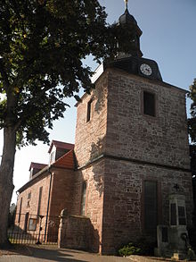
The village was first mentioned in 874 in a document from Ludwig the German . Wolfgang Kahl researched the first documentary mention of Ichstedt for the period from 750 to 802. The fortified church Ichstedt is the structural remainder of a parish church built around 1200, also called the "Old Tower" and is considered the oldest fortified church in Thuringia. There was once a moated castle in the village , which was located on the area of the later estate. It was used to monitor and secure the helmet transition . In the 18th / 19th A comprehensive renovation took place in the 19th century. A fire in 1970 largely destroyed Ichstedt Castle, so that only one wing of the building and the enclosing walls of the core facility remain today. Until 1918 the place belonged to the rule of the Principality of Schwarzburg-Rudolstadt .
The center of the village is the Hauptstraße – Schlossplatz . There is a settlement on the western edge of the village.
On January 1, 2019, the Ichstedt community was incorporated into the city of Bad Frankenhausen / Kyffhäuser. The community belonged to the administrative community Mittelzentrum Artern .
Population development
Development of the population (December 31) :
|
|
|
|
- Data source: Thuringian State Office for Statistics
Economy and Infrastructure
Ichstedt has no rail connection, the nearest train station is around 8 km east in Artern (Thuringia). Ichstedt is connected to the neighboring villages of Borxleben , Udersleben (town of Bad Frankenhausen) and Ringleben via secondary roads . In Bad Frankenhausen there is a connection to the federal highway 85 , in Sangerhausen to the Autobahn A 38 ( Göttingen - Halle ). Since 2015 there has been a connection to the A 71 ( Erfurt - Sangerhausen) via a driveway in Artern .
Attractions
The Wigberti Church is in the center of the village . It was rebuilt in its current form between 1717 and 1718 on the site of the previous church.
Sons and daughters of the place
- Karl August Rüdiger (1793–1869), classical philologist and educator
Individual evidence
- ^ Wolfgang Kahl: First mention of Thuringian towns and villages. Rockstuhl Verlag, Bad Langensalza, 2010, ISBN 978-3-86777-202-0 , p. 131.
- ↑ Michael Köhler: Thuringian castles and fortified prehistoric and prehistoric living spaces Jenzig-Verlag, 2001, ISBN 3-910141-43-9 , p. 146.
- ^ Superintendent Kristóf Bálint: Ichstedt in the parish area Bad Frankenhausen (church district Bad Frankenhausen-Sondershausen). Retrieved April 18, 2017 .
