
Kalbsrieth
| coat of arms | Germany map | |
|---|---|---|

|
Coordinates: 51 ° 21 ' N , 11 ° 20' E |
|
| Basic data | ||
| State : | Thuringia | |
| County : | Kyffhäuserkreis | |
| Fulfilling municipality : | Artern | |
| Height : | 121 m above sea level NHN | |
| Area : | 11.97 km 2 | |
| Residents: | 629 (Dec. 31, 2019) | |
| Population density : | 53 inhabitants per km 2 | |
| Postal code : | 06556 | |
| Area code : | 03466 | |
| License plate : | KYF, ART, SDH | |
| Community key : | 16 0 65 042 | |
| Association administration address: | At the Westbahnhof 06556 Artern |
|
| Mayor : | Uwe Ludwig | |
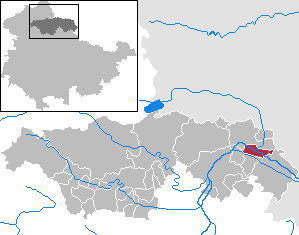
| Location of the municipality of Kalbsrieth in the Kyffhäuserkreis | ||
  |
||

Kalbsrieth is a municipality in the Kyffhäuserkreis in Thuringia . It lies at the mouth of the helmets in the Unstrut .
The district of Ritteburg belongs to Kalbsrieth .
history
The two grave mounds Derfflinger Hügel and Huthügel indicate a long-lasting prehistoric settlement in the area around Kalbsrieth.
Ritteburg is believed to have been the site of the Battle of Riyadh in 933. The former moated castle "Ritteburg" is said to have been built as early as the 8th century to control and secure the Unstrut crossing. In Hersfelder tithe directory this castle has been mentioned with. In 932 and 972 the German kings were there. It is believed that this place was called Riade, where King Henry I and his armored riders defeated the Hungarians in 933. In the year 1000 the complex was donated to the Archbishop of Magdeburg. Otherwise nothing is known about the castle and its location.
The place name Kalbsrieth is derived from the knights of Kalb, who have lived here since the 15th century. The Lords of Kalb have been an aristocratic family that can be traced back to the village since the 15th century, their moated castle , which was once located in the northeastern area of the village , was destroyed by the Swedes in the Thirty Years' War and replaced around 1690 by a representative castle on which Goethe several times near Charlotte von Kalb Was a guest. With effect from October 1, 1945, Kalbsrieth, which had previously been in Thuringia, was assigned to the Sangerhausen district of the Province of Saxony .
Until its dissolution on January 1, 2019, the community belonged to the administrative community Mittelzentrum Artern , since then the city of Artern has been a fulfilling community for Kalbsrieth.
Population development
Development of the population (December 31) :

|
|
|
|
|
- Data source: Thuringian State Office for Statistics
Personalities
- Martin Bierbach (1926–1984), diplomat, ambassador of the GDR to the PR China, Egypt, Great Britain and Ireland
- Charlotte von Kalb (1761–1843), writer, owner of Kalbsrieth Castle
- Ernst von Wolzüge (1855–1934), writer, found his final resting place in Kalbsrieth
- Otto Tiersch , music theorist, born in Kalbsrieth
- Johann Gottfried Gottlob Mühlig , naturalist, born in Kalbsrieth


Attractions

- The Kalbsrieth Castle with its remarkable landscape park was in 1821 by the family Wolzogen taken after the previous owners were forced to sell by impending financial ruin this possession. The castle was then redesigned in the classical style of the Goethe era and equipped with a collection of works of art. After the end of the war, the castle was made available as an apartment for emigrants, the valuable furnishings, doors, windows, ovens and stucco as features of the valuable classicist interior design were lost. Since the fall of the Wall, a support association has been trying to preserve parts of the park and buildings.
- St. John's Church
Individual evidence
- ^ Population of the municipalities from the Thuringian State Office for Statistics ( help on this ).
- ↑ Thomas Bienert: Medieval castles in Thuringia . Wartberg Verlag 2000, ISBN 3-86134-631-1 , p. 155.
- ^ Franz Brümmer : Tiersch, Otto . In: Allgemeine Deutsche Biographie (ADB). Volume 38, Duncker & Humblot, Leipzig 1894, p. 288 f.
- ^ Wilhelm Stricker: Mühlig, Johann Gottfried Gottlob . In: Allgemeine Deutsche Biographie (ADB). Volume 22, Duncker & Humblot, Leipzig 1885, p. 481.
- ↑ "Kalbsrieth" . In: Sparkassen-Kulturstiftung Hessen-Thüringen (Hrsg.): Cultural discoveries. Eichsfeld district, Kyffhäuserkreis, Nordhausen district, Unstrut-Hainich district . tape 1 (Thuringia). Schnell & Steiner, Regensburg 2009, ISBN 978-3-7954-2249-3 , pp. 119 .
Web links
Abtsbessingen | On the jewelry | Artern | Bad Frankenhausen / Kyffhäuser | Bellstedt | Borxleben | Clings | Revival | Etzleben | Freienbessingen | Farmyard | Greetings | Großenehrich | Helbedündorf | Holzsußra | Kalbsrieth | Kyffhäuserland | Mönchpfiffel-Nikolausrieth | Niederbösa | Upper Evil | Oberheldrungen | Reinsdorf | Rockstedt | Roßleben-Wiehe | Sondershausen | Topfstedt | Trebra | Wasserthaleben | West Greussia | Wolferschwenda