
Wolferschwenda
| coat of arms | Germany map | |
|---|---|---|
 Help on coat of arms |
Coordinates: 51 ° 14 ' N , 10 ° 48' E |
|
| Basic data | ||
| State : | Thuringia | |
| County : | Kyffhäuserkreis | |
| Fulfilling municipality : | Life | |
| Height : | 275 m above sea level NHN | |
| Area : | 4.27 km 2 | |
| Residents: | 139 (Dec. 31, 2019) | |
| Population density : | 33 inhabitants per km 2 | |
| Postal code : | 99713 | |
| Area code : | 036370 | |
| License plate : | KYF, ART, SDH | |
| Community key : | 16 0 65 082 | |
| Address of the municipal administration: |
Rathausstrasse 2 99713 Ebeleben |
|
| Mayoress : | Nicole Anton | |
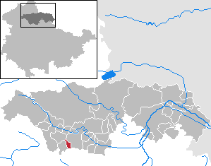
| Location of the municipality Wolferschwenda in the Kyffhäuserkreis | ||
  |
||


Wolferschwenda is a municipality in the Kyffhäuserkreis in Thuringia . The fulfilling community is the city of Ebeleben .
geography
The community is located on the edge of the Thuringian Basin northeast of the Heilinger Heights between the communities of Großenehrich and Freienbessingen . There is a bus connection to Ebeleben and Großenehrich.
history
Wolferschwenda was first mentioned in a document from Emperor Otto II as Voulfheresvouinidon . The place was fortified in the Middle Ages. In 1511 a linden tree was planted, which was felled in 1962. In 1560 Wolferschwenda came into the possession of the Counts of Schwarzburg. The Reformation arrived in the 16th century , but it wasn't until 1699 that the place received its own rectory. In 1778 a bakery was built. In 1855 Wolferschwenda got an inn. A school was built in 1899. Until 1918 the place belonged to the rule of the principality Schwarzburg-Sondershausen . In 1923 Wolferschwenda was connected to the electricity network.
Before the arrival of the US troops at the beginning of April 1945, most of the residents had sought refuge outside the village, in the trench cut at the Kleiner Bennebach. Then US reconnaissance tanks drove with two farmers as a "protective shield" into the almost deserted village. It was searched house by house for members of the Wehrmacht.
At the beginning of July 1945 Wolferschwenda, like all of Thuringia, was handed over by the Americans to the Red Army in implementation of the resolutions of the Yalta Conference and thus part of the Soviet Zone and, from 1949, of the GDR .
Population development
Development of the population (December 31) :
|
|
|
|
|
politics
The local council has 6 members (all free voters association).
Culture and sights
- The Evangelical Church of St. Nicolai is essentially a medieval hall church with a roof turret . Renovations were carried out in 1700 and 1805. The interior was renovated in 1920. The interior and furnishings date largely from the 17th and 18th centuries, but have a color from 1920. The rectangular hall contains two-storey, three-sided galleries and a continuous wooden barrel . From an earlier vaulted, presumably segregated choir , the vault at the southeast corner has been preserved. The cafeteria is medieval. The pulpit altar , which was rebuilt in the 19th century, is from the 1st half of the 17th century.
Personalities
- Johann Christian Quandt the Elder (1704–1750), clergyman and member of the Moravian Brethren
Web links
Individual evidence
- ^ Population of the municipalities from the Thuringian State Office for Statistics ( help on this ).
- ^ Jürgen Möller: The fight for northern Thuringia in April 1945. Rockstuhl Publishing House, Bad Langensalza 2010. P. 95. ISBN 978-3-86777-212-9
- ↑ Georg Dehio , edited by Stephanie Eißing and others: Handbuch der deutschen Kunstdenkmäler. Thuringia . 2nd Edition. Deutscher Kunstverlag , Munich / Berlin 2003, ISBN 3-422-03095-6 , p. 1399 f.
Abtsbessingen | On the jewelry | Artern | Bad Frankenhausen / Kyffhäuser | Bellstedt | Borxleben | Clings | Revival | Etzleben | Freienbessingen | Farmyard | Greetings | Großenehrich | Helbedündorf | Holzsußra | Kalbsrieth | Kyffhäuserland | Mönchpfiffel-Nikolausrieth | Niederbösa | Upper Evil | Oberheldrungen | Reinsdorf | Rockstedt | Roßleben-Wiehe | Sondershausen | Topfstedt | Trebra | Wasserthaleben | West Greussia | Wolferschwenda