
Freienbessingen
| coat of arms | Germany map | |
|---|---|---|
 Help on coat of arms |
Coordinates: 51 ° 14 ' N , 10 ° 47' E |
|
| Basic data | ||
| State : | Thuringia | |
| County : | Kyffhäuserkreis | |
| Fulfilling municipality : | Life | |
| Height : | 289 m above sea level NHN | |
| Area : | 8.91 km 2 | |
| Residents: | 227 (Dec. 31, 2019) | |
| Population density : | 25 inhabitants per km 2 | |
| Postal code : | 99713 | |
| Area code : | 036370 | |
| License plate : | KYF, ART, SDH | |
| Community key : | 16 0 65 018 | |
| Address of the municipal administration: |
Rathausstrasse 2 99713 Ebeleben |
|
| Website : | ||
| Mayor : | Helmut Penzler | |
| Location of the community of Freienbessingen in the Kyffhäuserkreis | ||
  |
||

Freienbessingen is a municipality in the Kyffhäuserkreis in Thuringia . The fulfilling community is the city of Ebeleben .
location
Freienbessingen is located in the fertile Thuringian Basin northeast on the edge of the Heilinger Heights .
history
A barrow of the Baalberg culture lies in the bump between mid-summer, Blankenburg and Freienbessingen. The gallows later stood in this place. The first documentary mention of the place was in the year 731. In Freienbessingen a deed of donation from the year 979 is considered as the first mention, in which also some surrounding places (eg Wolferschwenda) are mentioned. Accordingly, the 1025th anniversary was celebrated in 2004.
The place belonged to the Electoral Saxon Office Langensalza until 1815 and after its cession to Prussia from 1816 to 1944 to the district of Langensalza in the province of Saxony . The large manor of Freienbessingen was owned by the Erfurt factory owner and Rittmeister a. D. Fritz Wolff (malt factory in Erfurt). He generously expanded the estate. After the occupation by the Red Army , the property was expropriated without compensation. The good became VEG . Today (2012) it is a monastery property.
During fighting with the Americans on April 10, 1945, a German tank burned down in the village. The crew of three are found among the four unknown German soldiers in the cemetery in a communal grave.
An NVA missile base was located in the Heilinger Heights south of Freienbessingen . It was taken over by the German Armed Forces at short notice in the autumn of 1990; the former NVA soldiers were still dismantling the military equipment. Then the "Waldsiedlung" became an asylum seekers' home , which was closed in 2007 and then torn down.
Population development
Development of the population (December 31) :
|
|
|
|
|
- Data source: Thuringian State Office for Statistics
The dramatic decrease in the number of inhabitants from 2006 to 2007 is due to the closure of a collective shelter for refugees in October 2007.
Personalities
- Ferdinand Menge (1876–1962), painter and graphic artist
Attractions
- Church of St. Mariae from the 17th century

Church in Freienbessingen
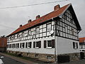
Half-timbered house in Freienbessingen

Manor house of the estate in Freienbessingen


Individual evidence
- ^ Population of the municipalities from the Thuringian State Office for Statistics ( help on this ).
- ↑ Michael Köhler: Pagan Shrines Jenzig Verlag 2007 ISBN 978-3-910141-85-8 , p. 135
Web links
Abtsbessingen | On the jewelry | Artern | Bad Frankenhausen / Kyffhäuser | Bellstedt | Borxleben | Clings | Revival | Etzleben | Freienbessingen | Farmyard | Greetings | Großenehrich | Helbedündorf | Holzsußra | Kalbsrieth | Kyffhäuserland | Mönchpfiffel-Nikolausrieth | Niederbösa | Upper Evil | Oberheldrungen | Reinsdorf | Rockstedt | Roßleben-Wiehe | Sondershausen | Topfstedt | Trebra | Wasserthaleben | West Greussia | Wolferschwenda