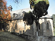
Bellstedt
| coat of arms | Germany map | |
|---|---|---|
 Help on coat of arms |
Coordinates: 51 ° 16 ' N , 10 ° 47' E |
|
| Basic data | ||
| State : | Thuringia | |
| County : | Kyffhäuserkreis | |
| Fulfilling municipality : | Life | |
| Height : | 225 m above sea level NHN | |
| Area : | 4.77 km 2 | |
| Residents: | 162 (Dec. 31, 2019) | |
| Population density : | 34 inhabitants per km 2 | |
| Postal code : | 99713 | |
| Area code : | 036020 | |
| License plate : | KYF, ART, SDH | |
| Community key : | 16 0 65 005 | |
| LOCODE : | DE B5L | |
| Address of the municipal administration: |
Rathausstrasse 2 99713 Ebeleben |
|
| Mayor : | Thomas Trietchen (independent) | |
| Location of the municipality of Bellstedt in the Kyffhäuserkreis | ||
Bellstedt is a municipality in the Kyffhäuserkreis in Thuringia . The fulfilling municipality (administrative location) is the nearby town of Ebeleben .
geography
Bellstedt is located in the northwestern part of the Thuringian Basin . The place is 12 km (air line) southwest of Sondershausen and 4 km (air line) southeast of Ebeleben. Bellstedt lies on the left bank of the Helbe .
history
Bellstedt was called Baldersteti , Bilistat and Bilistade in old documents .
During the Thirty Years' War Bellstedt and Thuringia were for a long time branches of Hohenebra , as the pastor there worked in Bellstedt from 1629 to 1640. This status ended in 1657 when the place received its own pastor again.
Until July 1, 1850 Bellstedt was a court village in which the manor was responsible for jurisdiction. She was also entitled to patronage over the school and church . Here, the local pastor was filled in alternation with the sovereign, because he continued to have patronage over the branch church in Thuringia. Originally, the church patronage was granted to the Ilfeld Monastery .
Population development
Development of the population (December 31) :
|
|
|
|
|
- Data source: Thuringian State Office for Statistics
Culture and sights
politics
In the Thuringian state elections in 2014, the NPD achieved 24.1% of the second vote in Bellstedt (with a state result of 3.6%), its record result in a comparison of all Thuringian municipalities.
economy
Like many other places in the Thuringian Basin, Bellstedt is characterized by agriculture (e.g. rapeseed, grain, maize and potatoes).
Personalities
- Thilo Apel (1822–1860), landowner, senior bailiff and member of the state parliament
Web links
Individual evidence
- ^ Population of the municipalities from the Thuringian State Office for Statistics ( help on this ).
- ↑ Friedrich Apfelstedt : Heimatskunde for the residents of the principality Schwarzburg-Sondershausen. First issue. Sondershausen 1854, p. 145.


