
West Greussia
| coat of arms | Germany map | |
|---|---|---|

|
Coordinates: 51 ° 14 ' N , 10 ° 55' E |
|
| Basic data | ||
| State : | Thuringia | |
| County : | Kyffhäuserkreis | |
| Management Community : | Greetings | |
| Height : | 175 m above sea level NHN | |
| Area : | 8.46 km 2 | |
| Residents: | 363 (Dec. 31, 2019) | |
| Population density : | 43 inhabitants per km 2 | |
| Postal code : | 99718 | |
| Area code : | 03636 | |
| License plate : | KYF, ART, SDH | |
| Community key : | 16 0 65 079 | |
| Association administration address: | Bahnhofstrasse 13a 99718 Greussen |
|
| Website : | ||
| Mayoress : | Rosemarie Krause ( CDU ) | |
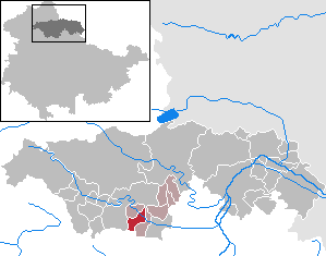
| Location of the municipality of Westgreußen in the Kyffhäuserkreis | ||
  |
||

Westgreußen is a municipality in the Thuringian Kyffhäuserkreis , two kilometers northwest of Greußen . It belongs to the administrative community Greußen .


history
West Greussia was first mentioned in 817 in a document to the Fulda monastery . As fiefs of the Landgrave and the Counts of Hohnstein and Schwarzburg-Sondershausen , there were nine noble manors in the Middle Ages. Westgreußen belonged until 1918 to sub-rule of the Principality of Schwarzburg-Sondershausen.
On April 10, 1945, four German self-propelled guns with twin flak mounted on them stood camouflaged in front of the community tavern. They were discovered during an attack by American fighter bombers and bombed despite defensive fire. Three German soldiers burned to death and were buried in the community cemetery, along with a German airplane pilot who was shot down in an aerial combat on April 9.
Like all of Thuringia, West Greussia was handed over by the Americans to the Red Army at the beginning of July 1945 and thus part of the Soviet Zone and, from 1949, of the GDR .
Population development
Development of the population (December 31) :
|
|
|
|
|
- Data source: Thuringian State Office for Statistics
coat of arms
Blazon : "Three stylized silver lilies with green stems and leaves in gold on a brown hill."
The origin of the coat of arms is not clear. It is believed that the family coat of arms of those from Salfeld was adopted. This family lived in West Greussia around 1500 and had three stylized lilies in their coat of arms. Older seals, including the one valid until 1950, showed the three lilies.
The coat of arms was drawn by Ulrich Müller from West Graubünden .
Culture and sights
Historic sites
The Funkenburg was a fortified settlement in the corridor of the Westgreußen community and between 200 BC. Settled in BC and AD 50. It was on a flat mountain spur sloping steeply on three sides. The site was already known as an archaeological site from field inspections when extensive investigations began in the 1970s, which were continued in several stages until 1980. In the area secured by a moat and palisade ring with a watchtower, storage and residential buildings were determined around a “chief's house” and several places of worship in the center of the settlement. The "castle" built in the Celto-Germanic contact zone was in use until the 1st century BC. Inhabited.
The concept for the "reconstruction" of the Funkenburg was worked out in the following years by a local association under the scientific guidance of the Museum of Prehistory and Early History of Thuringia . On the basis of the excavation results, thought was given to the establishment of an archaeological open-air site as early as 1977.
After the fall of the Wall, the area designated as a ground monument became a center for experimental archeology in Thuringia, in addition to the pottery workshop near Haarhausen . The events in the Funkenburg offer insights into life 2000 years ago. Food preparation, the production of clothing, jewelry, weapons and utensils and the necessary craft techniques are explained.
Buildings
- Church of St. Martin, the Romanesque tower of which dates from 1250 to 1300
- Weir of the Helbe in West Greussia

Memorial to the soldiers who died in 1939–1945 in the Westgreußen churchyard

Community gift and mayor's office in West Greussia
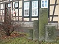
Memorial for four soldiers in front of the community tavern in Westgreußen

Tomb for four soldiers in the West Greussian cemetery


Personalities
- Caesar von Dachröden (* 1808 in Westgreußen, † 1882 in Rome), officer, court marshal and leading Freemason
- Edmund König (1858–1939), educator, local politician and philosopher
Individual evidence
- ^ Population of the municipalities from the Thuringian State Office for Statistics ( help on this ).
- ↑ Jürgen Möller: The fight for northern Thuringia in April 1945. Rockstuhl Publishing House, Bad Langensalza 2010. P. 132. ISBN 978-3-86777-212-9
- ^ New Thuringian Wappenbuch Volume 2, page 32; Publisher: Arbeitsgemeinschaft Thüringen eV 1998 ISBN 3-9804487-2-X
- ↑ Historical Guide. Sites and monuments of history in the districts of Erfurt, Gera, Suhl . Urania-Verlag, Leipzig-Jena-Berlin 1978, Westgreußen, p. 66 .
- ^ Verein Funkenburg Westgreußen eV (No longer available online.) Funkenburg-Verein, 2011, archived from the original on November 19, 2013 ; retrieved on July 30, 2011 : “The local group members at that time reconstructed the fortified tower integrated into the wall with simple means in the evening and indicated the height and extent of the main building with boundary posts. Only the reconstructed moat between the outer and main castle remained after the excavation. In 1990 and 1991 the local group suggested the complete reconstruction of the complex. After extensive discussions between the Thuringian State Office for Archaeological Monument Preservation Weimar, the cultural office of the Sondershausen district (today Kyffhäuserkreis), the Westgreußen community, the Funkenburg Westgreußen eV association, the non-profit support company for work and the environment and other institutions, the reconstruction could begin on December 1st, 1992 was completed in 1999. “ Info: The archive link was automatically inserted and not yet checked. Please check the original and archive link according to the instructions and then remove this notice.
Web links
Abtsbessingen | On the jewelry | Artern | Bad Frankenhausen / Kyffhäuser | Bellstedt | Borxleben | Clings | Revival | Etzleben | Freienbessingen | Farmyard | Greetings | Großenehrich | Helbedündorf | Holzsußra | Kalbsrieth | Kyffhäuserland | Mönchpfiffel-Nikolausrieth | Niederbösa | Upper Evil | Oberheldrungen | Reinsdorf | Rockstedt | Roßleben-Wiehe | Sondershausen | Topfstedt | Trebra | Wasserthaleben | West Greussia | Wolferschwenda