
Holzsußra
| coat of arms | Germany map | |
|---|---|---|
 Help on coat of arms |
Coordinates: 51 ° 18 ' N , 10 ° 42' E |
|
| Basic data | ||
| State : | Thuringia | |
| County : | Kyffhäuserkreis | |
| Fulfilling municipality : | Life | |
| Height : | 255 m above sea level NHN | |
| Area : | 9.93 km 2 | |
| Residents: | 265 (Dec. 31, 2019) | |
| Population density : | 27 inhabitants per km 2 | |
| Postal code : | 99713 | |
| Area code : | 036020 | |
| License plate : | KYF, ART, SDH | |
| Community key : | 16 0 65 038 | |
| Address of the municipal administration: |
Rathausstrasse 2 99713 Ebeleben |
|
| Mayor : | Steffen Lupprian | |
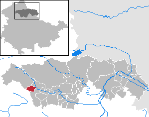
| Location of the municipality of Holzsussra in the Kyffhäuserkreis | ||
  |
||

Holzsußra is a municipality in the Kyffhäuserkreis in Thuringia . The city of Ebeleben is the fulfilling municipality for Holzsussra .
location
The rural town of Holzsußra is located west of the core community Ebeleben in an intensively used arable area in the far northwest of the Thuringian Basin . By the place "flows" channeled the water-poor Urbach , who from the west from the village Urbach comes. Between this and Holzsußra lies the scenic Urtal, a dry valley.
The county road 4 connects the village traffic fitted with Ebeleben in the east and Peukendorf in the West.
history
At the beginning of the 9th century, Sussra was first mentioned as Suzare in a list of the goods lent by Archbishop Lullus of Mainz († 786) to the monastery of Hersfeld von Free . Kahl found 842-856 in CE II cap. 40.2 the confirmation of the early first mention. At that time, several settlements with the name Sußra were possibly meant, because later the places Marksussra and Rockensussra received documents for the first mention. In addition to farms, there was an estate in Holzsussra. There was a chapel as early as the 8th century, and today's hall church was built in 1833/34. Until 1918, the place in the Ebeleben office belonged to the rule of the Principality of Schwarzburg-Sondershausen .
Population development
Development of the population (December 31) :
|
|
|
|
|
- Data source: Thuringian State Office for Statistics
traffic
The federal highways B 84 and B 249 run through the neighboring Ebeleben . The largely disused Greußen – Keula railway is north of the village .
societies
- Men's choir Holzsussra eV: emerged from the Liedertafel of 1848. Disbanded in 1945 and re-established a few years later as the Holzsussra folk choir.
- Youth initiative for Holzsußra eV: Association of young people and "young adults" founded the youth initiative for Holzsußra eV in 1999.
Regular events
- Carnival, Easter bonfire, May festival with setting a maypole, Whitsun festival, summer at the pond, fair, Oktoberfest, Advent singing.

Church in Holzsussra

Nave from the north

Guest house in Holzsussra

Manor house of the former estate


Individual evidence
- ^ Population of the municipalities from the Thuringian State Office for Statistics ( help on this ).
- ^ Wolfgang Kahl: First mention of Thuringian towns and villages. A manual. Verlag Rockstuhl, Bad Langensalza, 2010, ISBN 978-3-86777-202-0 , pp. 128, 174 and 234
Web links
Abtsbessingen | On the jewelry | Artern | Bad Frankenhausen / Kyffhäuser | Bellstedt | Borxleben | Clings | Revival | Etzleben | Freienbessingen | Farmyard | Greetings | Großenehrich | Helbedündorf | Holzsußra | Kalbsrieth | Kyffhäuserland | Mönchpfiffel-Nikolausrieth | Niederbösa | Upper Evil | Oberheldrungen | Reinsdorf | Rockstedt | Roßleben-Wiehe | Sondershausen | Topfstedt | Trebra | Wasserthaleben | West Greussia | Wolferschwenda