
Derfflinger Hills
| Derfflinger Hills | |||
|---|---|---|---|
 |
|||
|
|||
| Coordinates | 51 ° 19 '46.3 " N , 11 ° 21' 16.5" E | ||
| place | Kalbsrieth , Thuringia , Germany | ||
| Emergence | Neolithic , Early Bronze Age (expansion) | ||

The Derfflinger hill is a multiphase-used before - and prehistoric grave mound at Kalbsrieth in Kyffhäuserkreis , Thuringia . In 1901 an archaeological excavation took place under the direction of the archaeologist Armin Möller (1865–1938), which was published in 1912. The mound contained numerous burials that date back to the Neolithic . The oldest burial can not be precisely dated due to the lack of grave goods ; the remaining Neolithic burials can be assigned to the Baalberg culture (4200–3100 BC), the spherical amphora culture (3100–2700 BC) and the cord ceramic culture (2800–2200 BC). Other burials date from the Early Bronze Age Unetice culture (2300-1550 v. Chr.), The late Iron Age Latènezeit (450 v. BC-0), the Merovingian period (5th century-751) as well as generally from early Christian times. A funeral could not be classified in terms of time. The finds from the hill are now in the Museum of Prehistory and Early History of Thuringia in Weimar .
location

The hill is located 1.7 km southeast of Kalbsrieth in the direction of Schönewerda on the left bank of the Unstrut . It is visible from afar on the highest elevation in the area. Another burial mound, the Huthügel, is located 800 m to the north . This was first erected by members of the Cord Ceramic Culture and, in addition to corresponding finds from this time, only showed remains of a possible early Bronze Age reburial. Further ceramic burials were discovered in at least five places in the vicinity: On the parcel "In der Loh" 3 km east-south-east of Kalbsrieth, south-east on the way to Schönewerda, 2.5 km south-east of the village in the gravel pit Klasing am Rabenhüttenhügel, in one Another gravel pit between Kalbsrieth and Schönewerda and in a gravel pit east of the way to Artern . There are also individual finds from several locations in the municipality.
Surname
The origin of the name of the hill is unclear. Möller accepted a connection with the Brandenburg General Field Marshal Georg von Derfflinger , who led his troops through Thuringia in June 1675 in the war against Sweden . Möller could not determine whether he also came through Kalbsrieth.
Research history
The hill aroused the interest of several amateur researchers as early as the 19th century. A test excavation was found on the west side, but it is unclear when and by whom it was carried out. The accounting officer Reinhard from Buttstädt dug without success on the north side of the hill. Oscar Förtsch from Halle (Saale) and the mayor of Kalbsriether Freysold also dug on the north side . They found a black, polished urn that was brought to the State Museum of Prehistory in Halle, where Möller could not find it later. Finally, between July and October 1901, Armin Möller, curator of the Weimar City Museum , carried out extensive excavations on the hill for six weeks, which he published in 1912.
description
The hill

The existing soil under the mound is made of limestone with a layer of plaster running under it. The hill itself was expanded again and again in several phases. Originally it was probably roughly round, but was later greatly expanded to the east, giving it an approximately trapezoidal shape. The southern and western sides of the hill are still well preserved, but the north side is heavily plowed, as is the east side. Skeletal parts and ceramic shards are said to have been exposed over and over again. The original height of the hill should have been 4.10 m. The diameter from north to south was 17.20 m in Möller's investigation, but it should originally have been at least 28 m.
The oldest phase of the hill is a natural rocky dome with a simple grave pit that was covered with a 0.6 m thick layer of earth. This was covered with a layer of small slabs and chunks of sand and limestone with a thickness of 0.2 m in the middle and 0.1 m at the edge. A further layer of earth was laid over this layer of stone, but it was only at a very small point that it was clearly distinguishable from the later embankment. The height of the second layer of earth could be determined to be about 0.5–0.6 m. Möller estimated the diameter of the primary mound to be at least 12 m. In the early Bronze Age, the hill was enlarged to its present size in a final phase.
The oldest Neolithic burial
The oldest grave was sunk into the crest of the naturally existing hill. It was a simple earth pit with a width of 0.6 m and a length of 1.1 m at the top and 0.98 m at the bottom. The depth was only between 0.25 and 0.28 m. The walls and floor had only been machined and not smoothed. The pit was filled with black earth and contained a skeleton lying in an extreme stool position. The bones were very badly preserved. Grave goods were not found.
Dolmen and stone box of the Baalberg culture and the spherical amphora culture

At the foot of the east side of the primary mound, a complex of two stone burial chambers and two stone pavements was built on the existing ground. The western chamber was a small, east-west oriented ancient dolmen . It consisted of two wall stones and a capstone made of red sandstone . There were three slabs of sandstone on the capstone. The whole building was in turn encased by a 0.9 m high pile of stones , which had been built from various field stones and 35-40 fragments of millstones .
It was not possible to determine with certainty whether the dolmen had been used for a regular burial. No human remains were found except for two teeth.
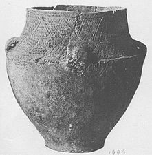
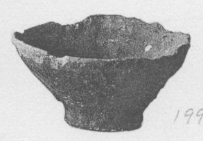
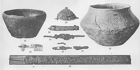
The dolmen contained two ceramic vessels as gifts. The first was a four-handled, undecorated amphora with a height of 15.3 cm and a maximum diameter of 12 cm. This is a typical form of the Baalberg culture. The second vessel was a handle bowl with a height of 8.7 cm and a mouth diameter of 16.2 cm.
- Additions from the dolmen
Amphora

Handle bowl


A shell stone was found between the bed of stones above the dolmen and the stone box to the east . It consisted of brown coal quartzite and was 46 cm long, 41 cm wide and 18 cm thick. Its top had five bowls.

The stone box was also oriented east-west. It consisted of a floor panel and four wall panels. All slabs were made of sandstone; the joints in the wall panels were covered with plaster . A residue of plaster on the top of the western wall panel as well as other pieces of plaster and sandstone fragments in the earth above the box indicate the original presence of a cover panel. The box had an internal length of 1.7 m and a width of 0.94 m. The rather narrow wall panels were stabilized by smaller stone panels leaning against the outside. A further, upright slab formed a 0.6 m wide vestibule open to the north and south in front of the narrow eastern side. Charcoal, ashes, burnt bones and indeterminable ceramic shards were found in the anteroom.
The box contained two burials, only one of which was well preserved. It was the complete skeleton of a 33–40 year old man in a crouched position on the left with his head to the east and a view to the south. A healed blow injury was found on the skull. The second burial was a 1.5–2.5 year old child. Only a few very thin fragments of the skull remained from this.
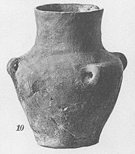
The grave contained numerous grave goods. Four ceramic vessels lay or stood in front of the adult man's forehead: one decorated and one undecorated spherical amphora and two decorated four-handled pots . A bowl was found at the body's feet. A double bone needle lay between the lower legs and a simple bone needle on the outside of the left tibia. There was a bone awl above the left knee . In the earth above the chest was a flint - ax discovered. Three boar teeth were found on jewelry items, at least two of which were pierced. Two of them were below the awl above the knee and the third on the left foot. Finally, some food had been given to the dead. The lower jaw, an upper arm, a thigh, two feet and two toe bones of a pig and a lower leg of a crane were preserved.
- Additions from the stone box

Spherical amphora
pot
Spherical amphora

pot
ax
Bowl
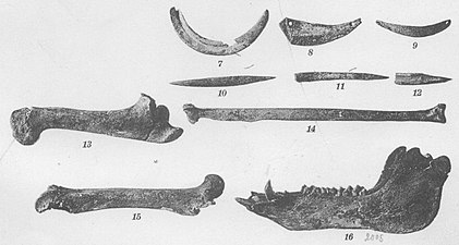
Animal bones, bone implements and jewelry


To the north and south of the stone box there were two oval stone pavements. The southern one was 0.7 m away from the stone box and 0.6 m above the ground. It had a diameter of 1.1 m from east to west and 1 m from north to south. The stone setting consisted of a central stone with a diameter of 60 cm, which was surrounded by nine smaller, irregular slabs. All were made of yellow and red sandstone. The spaces in between were possibly filled with clay , but the few remains that were found could also have been part of the filler soil. Discoloration on the middle stone as well as ash and charcoal remains show that the stone was used as a fireplace.
The second stone setting was 0.5 m north of the stone box. It was slightly trough-shaped and measured 1.55 m from north to south and a little more from east to west. This stone setting consisted only of smaller red sandstone slabs; the northern edge was bordered by vertical panels. The joints were carefully filled with sandy loam. Here, too, discoloration, ash and charcoal are evidence of its use as a fireplace. Furthermore, unburned pieces of bones, including cattle, as well as some ceramic shards that cannot be precisely identified were found here.
The corded ceramic burials


Three corded ceramic burials have been discovered on the southeastern edge of the primary mound. The three dead had been laid down in a right crouched position with their heads to the west and a view to the south and were each 0.6 m apart in a row running approximately north-south. They were not at the same depth, but staggered, with the pits for the southern and middle dead cut through the stone layer of the primary hill, so that the southern dead came to lie below and the middle one within the layer. The northern dead, however, was buried above the layer.
Some of the skeletons were still quite well preserved. A sex determination did not take place, but the position on the right side with the head in the west in the corded ceramic is typical for male burials. Several pathological growths on the bones of the foot were found in the southern body, as well as a healed fracture on the right shin . Due to the heavily worn teeth, it was concluded that the age at death was relatively high.
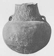
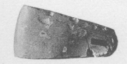
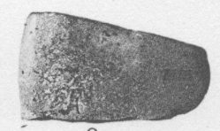
No grave goods were found in the southern body. A string cup and ax lay behind the skull of the middle dead man . The cup has a height of 18.2 cm; its diameter is 5.5 cm at the bottom, 8.5 cm at the narrowest point of the neck and 12 cm at the mouth. It has a spiral-shaped string ornament that runs from the mouth to about 7.3 cm above the ground. The ax is made of gray-black serpentine and has a length of 11.4 cm, a width of 5 cm and a thickness of 4.8 cm. In front of the hips of the northern dead lay a hatchet from flint with a length of 8.2 cm, a width of 4.7 cm and thickness of 1.7 cm a.
- Additions to the Cord Ceramic burials
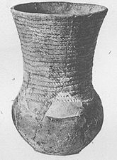
String cup
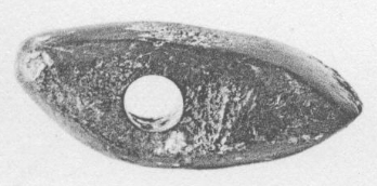
Axe
ax


The burial of the Aunjetitz culture
In the middle of the Bronze Age mound, about 1.3 m north of the east-west axis, Möller came across a tree coffin at a depth of 1.2-1.3 m . It was oriented east-west and had a length of 3.9 m, a width of 0.65 m and a height between 0.55 and 0.6 m; the wall thickness was 8-10 cm. The south side of the coffin was damaged by a later burial.
The skeleton was poorly preserved and was additionally damaged during the excavation. The dead man was buried with his head in the west. Nothing was left of the skull, only a rib and the rest of a collarbone of the torso . The basin was damaged during the rescue. Only the two thighs were relatively well preserved, the lower thighs were barely recognizable.
The coffin contained a total of five grave goods: a 3.9 cm fish hook made of bronze or copper was discovered between the head of the deceased and the end of the coffin . There is no exact location description for the remaining items. It is a faceted hammer ax made of blue-green silica slate and three ceramic vessels: a typical Aunjetitz cup, a bowl with a wart handle and a miniature urn only 4.2 cm high and a maximum diameter of 4.6 cm. In the case of the shell, it is not certain whether it was placed directly in the coffin, because it was found between the lower legs of the dead man, where the bottom of the coffin was not preserved. Möller could not rule out that it came from below the tree coffin, but could not find another grave there.
- Additions from the Aunjetitz burial

Cup

Bowl, miniature urn, fish hook and faceted ax


The burials of the La Tène period

On the east side of the enlarged hill, four Latène period burials were discovered at depths between 0.6 and 1 m. One burial was on the north-eastern edge of the hill, two more on the eastern edge, a little north of the east-west axis and the fourth in the north-east at the bottom of the hill on the ground, just outside the still-preserved mound. All four cases involved urn burials, but they were all damaged by the later Christian burials. An urn had been split in the middle. The urns were probably placed directly in the earth of the mound; A possible stone setting was only found in one case, but this is not guaranteed by the later disturbance. None of the urns was completely preserved. According to Möller, the remains of corpse burns that still existed indicated adult burials in all cases. Only two grave goods could be found: It was a piece of iron that could not be defined more precisely, perhaps from a fibula and a bowl-shaped bronze earring . Due to the poor state of preservation of the urns and the few additions, it was not possible to date the burials more precisely.
The shaft grave of the Merovingian era
In the north-western part of the hill, a shaft grave was dug up to a depth of 50 to 60 cm below the surface of the hill. It had a rectangular floor plan, a length of 2.55 m and a width of 1 m. At the bottom of the shaft was a very old wooden coffin with the burial of a Frankish warrior. The burial was covered with oak planks and the shaft was then backfilled with earth. The dead man was buried stretched out on his back with his head facing the west. No information is available on skeletal remains.
The dead man's gifts included a sword ( spathe ) 89.6 cm long, which had been placed next to his left leg. The wooden scabbard was also preserved in remains. The armament also included a knife, an iron lance tip and a shield , from which the hump and the fetter were still preserved. The knife was found near the right shoulder of the dead man and had pieces of wood on the handle. The tip of the lance was at the dead man's feet and the shield on the right side of the body. Further iron finds could no longer be precisely determined; one piece could have been a buckle, and two more could have been the blades of a pair of scissors . A bone ridge was found on the head of the deceased , which was 20 cm long and was composed of five plates. Only an indeterminate piece of bronze was found on possible jewelry items. Outside the coffin stood two ceramic vessels at the foot of the coffin. It was a double-conical pot and bowl.
- Additions from the Merovingian burial
Bowl, pot, shield boss, lance tip, shield shackle, bone comb, knife, iron objects, sword

Detail view of the sword scabbard


Early Christian burials
A total of 91 early Christian row graves were discovered across the entire hill just below the surface . They were particularly concentrated in the middle of the hill and in a 5 m long row on the west and a 7 m long row on the east side. The burials were found at different depths: in the east it was only 25–30 cm, but this is due to pilling and erosion of the hill. In the middle of the hill it was 50 cm, the original burial depth should have been 70 cm. For all burials, simple wooden coffins were used, which were placed about 1.5 m apart on average, with a certain order being maintained only at the edges, while in the middle of new burials no attention was paid to older ones. With a few exceptions, the coffins were oriented east-west. One coffin apparently had a border made of additional boards on the long sides, some other coffins were partly bordered with stone slabs. The coffins were between 1.2 m (for children's burials) and 1.9 m long. Their width was between 0.45 and 0.55 m.
The dead lay stretched out on their backs with their heads facing west. No coffin could be found at a woman's burial. Most of the dead were buried individually, in three cases a child was buried and in one case two adults were buried in a coffin. The dead were of all ages. A quarter were adolescents, one person was concluded to have a high age at death due to the teeth worn down to the roots. Dolichocephaly was found in almost all of the skulls still intact .
Grave goods were found in only four cases: they were two iron knives, the rest of a square buckle and an indefinable piece of iron. An exact dating of the graves was not possible on the basis of these scanty finds.
Burial that cannot be determined in time

An irregular packing of sandstone pieces and limestone slabs was discovered on the western slope of the hill at a depth of 0.5 m. About 30 cm deeper, a loose sandstone pavement with wide gaps and traces of fire exposure was found. Immediately to the west of the stone pavement, the lower part of an adult skeleton was found. The lower vertebrae, the pelvis and the extremely spread and diamond-shaped angled legs were still preserved. The remains of a child's skeleton lay in a stretched position on the right leg. Here, too, only the legs and the pelvis were preserved. Only eight ceramic shards were found among the additions, which probably belonged to three vessels. They were not Neolithic, but otherwise could not be classified more precisely in time.
The hill in regional sagas
There are several legends about the Derfflinger Hügel : You shouldn't walk past it at night because it's uncomfortable there. A carriage with headless horses is supposed to pass the nearby path . Gypsies are said to have buried their dead here. In addition, a mighty king is said to be buried in a silver coffin in the hill. The latter in particular was apparently taken very seriously by the local residents. So Möller was pressured by an estate inspector to dig deeper to find the coffin. A very similar legend has been handed down from the grave mound of Rössen in Leuna in Saxony-Anhalt, almost 50 km to the east : There it is a king's son in a golden coffin.
The claim that shepherds bury their dead sheep in the hill, especially on the eastern slope, is probably also a legend. Möller could not find any animal skeletons during his excavation. Nor could he produce any evidence of bonfires on the top of the hill. However, the hilltop had been partially removed, which means that the corresponding layers of ash may not have been preserved.
literature
- Hans-Jürgen Beier : The spherical amphora culture in the Middle Elbe-Saale area and in the Altmark. Berlin 1988, ISBN 978-3-326-00339-9 , no.214.
- Hans-Jürgen Beier: The megalithic, submegalithic and pseudomegalithic buildings as well as the menhirs between the Baltic Sea and the Thuringian Forest. Contributions to the prehistory and early history of Central Europe 1. Wilkau-Haßlau 1991, p. 72.
- Sigrid Dušek : Prehistory and early history of Thuringia. Theiss, Stuttgart 1999, ISBN 978-3-8062-1504-5 , p. 66.
- Ulrich Fischer : The Stone Age graves in the Saale region. Studies on Neolithic and Early Bronze Age grave and burial forms in Saxony-Thuringia (= prehistoric research. Volume 15). De Gruyter, Berlin 1956, pp. 50, 54, 110, 112, 127, 129, 131, 150, 152 f., 155 f., 159, 173, 176, 179, 189, 195, 205–207, 218, 232, 239 f., 264, 281, 294, 305.
- Waldemar Matthias : Catalogs on Central German Cord Ceramics. Volume 4. South Harz-Unstrut area. Ulrich Fischer dedicated to the leading specialist in the field of string ceramics research on the occasion of his 60th birthday on July 3, 1975 in a collegial bond (= publications of the State Museum for Prehistory in Halle. Volume 28). Deutscher Verlag der Wissenschaften, Berlin 1974, pp. 150–152.
- Armin Möller : Derfflinger Hügel near Kalbsrieth (Grand Duchy of Saxony). A Thuringian necropolis from the Unstruttal from the Stone Age to the introduction of Christianity used (= commemorative publication for the 43rd general meeting of the German Anthropological Society August 4-8, 1912 in Weimar. Issue 3). Fischer, Jena 1912 ( online ).
- Hugo Mötefindt : Old and new about the spherical amphorae in the Saxon-Thuringian countries. In: Journal of Ethnology. Volume 47, 1915, pp. 45-52 ( online ).
- Nils Niklasson : The stratigraphic structure of the Baalberger hill near Bernburg, the Pohlsberg near Latdorf and the Derfflinger hill near Kalbsrieth. In: Mannus. Volume 16, 1924, pp. 46-54.
- Sven Ostritz (Ed.): Kyffhäuserkreis (= Archaeological Hiking Guide Thuringia. Volume 13). Beier & Beran, 2012, Langenweißbach 2012, ISBN 978-3-941171-58-9 , pp. 124-125.
- Andreas Sattler : The graves of the Aunjetitz culture in the Saale region. On the ritual of the dead based on the older findings (= university research on prehistoric archeology. Volume 267). Habelt, Bonn 2015, ISBN 978-3-7749-3941-7 , p. 122.
Web links
- The Megalithic Portal: Derfflinger Hügel
- KLEKs Online: Derfflinger Hügel
- bodendenkmale-thueringen.de: Kalbsrieth, Derfflinger Hügel
Individual evidence
- ↑ Armin Möller: Derfflinger Hügel near Kalbsrieth (Grand Duchy of Saxony). 1912, p. 1.
- ↑ Waldemar Matthias: Catalogs on Central German Cord Ceramics. Volume 4. South Harz-Unstrut area. 1974, pp. 148-150.
- ↑ Waldemar Matthias: Catalogs on Central German Cord Ceramics. Volume 4. South Harz-Unstrut area. 1974, pp. 150, 152-153.
- ↑ Waldemar Matthias: Catalogs on Central German Cord Ceramics. Volume 4. South Harz-Unstrut area. 1974, pp. 153-154.
- ↑ Armin Möller: Derfflinger Hügel near Kalbsrieth (Grand Duchy of Saxony). 1912, p. 2, note 1.
- ↑ Armin Möller: Derfflinger Hügel near Kalbsrieth (Grand Duchy of Saxony). 1912, pp. 4-6.
- ↑ Armin Möller: Derfflinger Hügel near Kalbsrieth (Grand Duchy of Saxony). 1912, pp. 2-3.
- ↑ Armin Möller: Derfflinger Hügel near Kalbsrieth (Grand Duchy of Saxony). 1912, pp. 13-14.
- ↑ Armin Möller: Derfflinger Hügel near Kalbsrieth (Grand Duchy of Saxony). 1912, pp. 11-14.
- ↑ Hans-Jürgen Beier: The megalithic, submegalithic and pseudomegalithic buildings as well as the menhirs between the Baltic Sea and the Thuringian Forest. Contributions to the prehistory and early history of Central Europe 1. Wilkau-Haßlau 1991, p. 72.
- ↑ Armin Möller: Derfflinger Hügel near Kalbsrieth (Grand Duchy of Saxony). 1912, pp. 38-39.
- ↑ Armin Möller: Derfflinger Hügel near Kalbsrieth (Grand Duchy of Saxony). 1912, p. 39.
- ↑ Armin Möller: Derfflinger Hügel near Kalbsrieth (Grand Duchy of Saxony). 1912, pp. 39, 42.
- ↑ Armin Möller: Derfflinger Hügel near Kalbsrieth (Grand Duchy of Saxony). 1912, p. 40.
- ↑ Armin Möller: Derfflinger Hügel near Kalbsrieth (Grand Duchy of Saxony). 1912, pp. 18-21.
- ↑ Armin Möller: Derfflinger Hügel near Kalbsrieth (Grand Duchy of Saxony). 1912, pp. 21-22.
- ↑ Armin Möller: Derfflinger Hügel near Kalbsrieth (Grand Duchy of Saxony). 1912, pp. 23-26.
- ↑ Armin Möller: Derfflinger Hügel near Kalbsrieth (Grand Duchy of Saxony). 1912, pp. 29-30.
- ↑ Armin Möller: Derfflinger Hügel near Kalbsrieth (Grand Duchy of Saxony). 1912, pp. 30-36.
- ↑ Armin Möller: Derfflinger Hügel near Kalbsrieth (Grand Duchy of Saxony). 1912, pp. 26-29.
- ↑ Armin Möller: Derfflinger Hügel near Kalbsrieth (Grand Duchy of Saxony). 1912, p. 36.
- ↑ Armin Möller: Derfflinger Hügel near Kalbsrieth (Grand Duchy of Saxony). 1912, pp. 36-37.
- ↑ Armin Möller: Derfflinger Hügel near Kalbsrieth (Grand Duchy of Saxony). 1912, pp. 14-17.
- ↑ Armin Möller: Derfflinger Hügel near Kalbsrieth (Grand Duchy of Saxony). 1912, p. 17.
- ↑ Armin Möller: Derfflinger Hügel near Kalbsrieth (Grand Duchy of Saxony). 1912, pp. 17-18.
- ↑ Armin Möller: Derfflinger Hügel near Kalbsrieth (Grand Duchy of Saxony). 1912, pp. 44-46.
- ↑ Armin Möller: Derfflinger Hügel near Kalbsrieth (Grand Duchy of Saxony). 1912, p. 45.
- ↑ Armin Möller: Derfflinger Hügel near Kalbsrieth (Grand Duchy of Saxony). 1912, pp. 46-48.
- ↑ Armin Möller: Derfflinger Hügel near Kalbsrieth (Grand Duchy of Saxony). 1912, pp. 49-51.
- ↑ Armin Möller: Derfflinger Hügel near Kalbsrieth (Grand Duchy of Saxony). 1912, pp. 51-52.
- ↑ Armin Möller: Derfflinger Hügel near Kalbsrieth (Grand Duchy of Saxony). 1912, pp. 52-59.
- ↑ Armin Möller: Derfflinger Hügel near Kalbsrieth (Grand Duchy of Saxony). 1912, pp. 59-61.
- ↑ Armin Möller: Derfflinger Hügel near Kalbsrieth (Grand Duchy of Saxony). 1912, pp. 61-63.
- ↑ Armin Möller: Derfflinger Hügel near Kalbsrieth (Grand Duchy of Saxony). 1912, p. 63.
- ↑ Armin Möller: Derfflinger Hügel near Kalbsrieth (Grand Duchy of Saxony). 1912, pp. 67-68.
- ↑ a b Armin Möller: Derfflinger Hügel near Kalbsrieth (Grand Duchy of Saxony). 1912, p. 2.