Kyffhäuser Geopark

The GeoPark Kyffhäuser is located south of the Harz Mountains and covers an area of around 800 km². This geopark is named after the Kyffhäuser Mountains , which combine many different forms of landscape in a very small space.
The GeoPark is dominated by the Kyffhäuser monument , which was built from the typical red sandstone of the region. In addition to this eye-catching building, many castles and palaces in the region show how the underground stone was used.
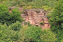
Quarries, the Barbarossa Cave or the adventure mine in Sondershausen provide insights into numerous rock layers . The results of archaeological excavations, such as the Tilleda Royal Palace or the Bilzingsleben site , are also part of the Geopark.
The extraction of brine and the boiling into table salt used to ensure the wealth of the region and today characterizes the salt landscape in the south of Bad Frankenhausen . Also Kupferschiefer was mined. Shaft towers or heaps in the region are still reminiscent of mining today.
