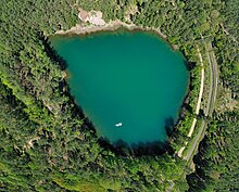
Muskauer fold arch
The Muskau fold arch in Brandenburg and Saxony ( Germany ) as well as in the Lebus Voivodeship ( Poland ) is a compression moraine from the Elster Ice Age . It is part of the Lusatian border wall . The Muskau Arch was added to the list of 77 national geotopes in 2006.
Geographical location
The Muskau arc extends on both sides of a portion of the German-Polish border forming Neisse in the form of an open north horseshoe of Doebern (Brandenburg) in the northwest on white water / Oberlausitz and Bad Muskau (both axes) in the south to Polish Trzebiel in Northeast over an area of about 250 km². Its highest point is located west of Doebern High Mountain ( 183.7 m above sea level. HN ). Other elevations include the Brandberg ( 175.3 m ) and the Dragon Mountains ( 162.8 m ).
Geology and mining
An up to 500 m thick glacier of the inland ice compressed the layers of sand and lignite lying in front of and below it over a length of more than 40 km to form a small-scale fold with a compression moraine up to 180 m high and 700 m wide. The structure has recently been preserved as a flat, undulating range of hills and is almost unique worldwide. The subsequently created meltwater lake within the horseshoe was filled with banded clay . Ice advances in the subsequent glacial periods eroded the higher parts of the terminal moraine. Due to oxidation and the associated loss of volume in the near-surface areas of the brown coal seams, terrain furrows from 3 m to 5 m, a maximum of 20 m deep, 10 m to 30 m wide and up to several kilometers long were formed. Named as Gieser , they form long stretches of drain-free trenches that are either filled with standing water or are often pitted.
While it was assumed for a long time that the folds were formed in the Saale Ice Age , according to more recent studies it was already formed in the Elster Ice Age . The fact that it lies in the area of a terminal moraine from the Saale period is more of a coincidental nature.

After centuries of extraction of clay and sand, lignite was mined in the area of the Muskau fold in the 19th and 20th centuries, partly in piers and partly in open-cast mining . Due to the location of the mined seams, after the end of mining, noticeably elongated lakes formed in the remaining holes north and east of Weißwasser.
Geoparks
On the German side, the entire area of this geological structure - including areas adjacent to the south - has been a geopark since 2003 . This was recognized as a National Geopark in Germany in 2006 and - together with its Polish sister Geopark - was certified as a Geopark of the European Geopark Network in 2011 . The UNESCO defined for a Geopark three overarching goals: preservation of healthy environment, stimulate sustainable economic development and geoscience knowledge. There are currently (as of 2018) 64 Geoparks in Europe that are certified by UNESCO as European Geopark and Global Geopark . Six of the 15 German geoparks received this international award and work together in a Europe-wide network.
On May 28, 2016, the award ceremony for the UNESCO Global Geopark title took place in Bad Muskau .
literature
- Manfred Kupetz: The Muskau fold arch - a geotope of European importance . In: Brandenburg Geoscientific Contributions , 1/1996, pp. 125–136, Kleinmachnow 1996.
- Almut Kupetz, Manfred Kupetz, Jochen Rascher: The Muskau folds arch - a geological phenomenon, the basis of 150 years of site-specific economic development and geopark in Brandenburg, Saxony and the Lubuser Land voivodeship . (Ed .: Society for Geosciences e.V., Berlin 2004)
Web links
- 360 ° aerial panorama near Kromlau
- Muskauer fold arches / Łuk Mużakowa on the UNESCO website for Global Geoparks (English).
- Muskau Arch Geopark
- Muskauer fold arch on the Spree-Neisse district side
Individual evidence
- ↑ Almut Kupetz, Manfred Kupetz: Footprint of a Glacier - The Ice Age Muskau Arch. In: Ernst-Rüdiger Look, Ludger Feldmann (Ed.): Fascination Geology. The important geotopes of Germany , E. Schweizerbart'sche Verlagsbuchhandlung, Stuttgart 2006, ISBN 3-510-65219-3 , p. 32f.
- ↑ Map services of the Federal Agency for Nature Conservation ( information )
- ↑ Muskau folds . Retrieved August 14, 2015.
- ↑ a b K. Goth: Arch of folds . In: Geological Calendar 2017 . German Geological Society,, ISBN 978-3-932537-61-5 .
- ↑ LMBV: Lusatian lignite district. Changes and perspectives. Trebendorfer Felder / Nochten / Reichwalde , pp. 26-27.
- ↑ Nationaler GeoPark Muskau fold arches , national-geopark.de, accessed on November 1, 2017.
- ↑ Muskau Arch / Łuk Mużakowa UNESCO Global Geopark on the list of UNESCO Geoparks (English) . Retrieved May 3, 2016
- ↑ Ceremonial handover of the UNESCO title , accessed on May 31, 2016.
Coordinates: 51 ° 32 ′ 57 ″ N , 14 ° 34 ′ 54 ″ E


