Geopark Grenzwelten
The Grenzwelten Geopark , spelling GeoPark GrenzWelten, is a so-called Geopark in the federal states of Hesse and North Rhine-Westphalia , in which the history of the earth is to be explained to visitors. The area of this park extends over 46 cities and municipalities as well as five districts ( Waldeck-Frankenberg , Marburg-Biedenkopf , Schwalm-Eder-Kreis , Kassel District , Hochsauerlandkreis ). The Geopark project opens up the geotouristic potential of the region and serves to promote sustainable regional development.
Geographical location
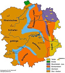
The park covers an area of 3710 km² and is one of the large-scale national geoparks. The main part of its area lies within the Waldeck-Frankenberg district in the north Hessian mountainous region. The Hessian neighboring districts of Marburg-Biedenkopf, Schwalm-Eder district, Kassel district and the North Rhine-Westphalian district of “Hochsauerland” also have territorial shares. The Geopark is divided into ten sub-regions. Each region contains a different focus of geological and cultural land history.
Regional geology
The park is characterized by a varied and structured geology, which has rocks from different ages. The oldest rocks come from the Silurian and can be found in the southern Kellerwald . In geological terms, a large part of the Geopark area is taken up by the so-called Rheinisches Schiefergebirge , which formed as a high mountain range in the course of the Variscan orogeny. The Kellerwald in the center of the Geopark, which is to be understood as the eastern foothills of the Rhenish Slate Mountains, consists mainly of clastic sedimentary rocks in the form of greywacke, clay and gravel slate.
In the late ancient times , the mountains were located near the equator. The tropical Zechstein Sea formed there as a result of the repeated marine ingression . Due to the hot climate and the periodic separation from the Panthalassa Ocean , there was repeated evaporation of the Zechstein Sea. Typical evaporite rocks such as lime, gypsum and rock salt emerged from the evaporation residues. On the overall backdrop of the Geopark, only the limestone was able to withstand the erosion. The Zechstein limestone, which has been handed down to this day, is located like a ribbon around the eastern edge of the Rhenish Slate Mountains and corresponds to the former coastline of the high mountains.
Stratigraphically, the red sandstone rests on the Zechstein and is accordingly younger. It originated under arid conditions in the Germanic Basin . At that time, erosion material from the Rhenish Slate Mountains sedimented into the large Central to Western European terrestrial sedimentation area. These large-scale deposits can be seen today, among other things, in the mighty sandstones of the castle forest .
The time of the terrestrial deposits was then replaced in the Muschelkalk (243-235 million years ago) by a marine ingression in the Germanic Basin. The shell limestone originated in a shallow tropical shelf sea from limestone and clay deposits. The formerly extensive fossil-bearing limestone was largely removed again in later stages of the earth's history.
In the Tertiary period, the Alpine orogeny created fracture zones in the earth's crust, where basaltic rock melts reached the earth's surface. The Vogelsberg and the many smaller craters in the Lower Hessian depression (Wolfhager Land) are witnesses of the strong volcanism at that time . The climate in the Tertiary was tropical and humid. At that time, lush forests grew there, which were sealed by the renewed penetration of the sea and today form the lignite deposits in the Borken area. Remnants of this marine indentation are preserved in the Kassel sea sands .
history
The idea for this geopark came from private individuals and scientists in 2001. The Waldeck-Frankenberg district later picked up on this idea and formed a working group of experts who pushed for the realization of a geopark with political support. The GrenzWelten Geopark was officially founded in spring 2006. In 2009 it was certified as a "National Geopark".
Tourist development

Numerous sights can be visited in the Geopark:
- Korbach column
- Adorf cliff
- Gold am Eisenberg (Korbach)
- Werbetal rock landscape
- Koppe Odershausen
- Bruchhauser stones
- Kilian tunnel in Marsberg
- Stedefelsen Allendorf
- Dinosaur tracks Wolfhagen
- Rodenbach quarry
- Castle forest moors
- Edersee Atlantis
- Sharp stone Volkmarsen
- Buhlen hunting station
- Karst caves
- Christiane mine in Adorf
- Burgberg tunnel in Battenberg
- Bertsch visitor mine in Berg Freiheit
- Eisenberg gold mine in Goldhausen
- Christine mine near Willingen
- Hessian lignite mining museum in Borken
- Dreislar barite mine
- Sauerländer Besucherbergwerk Ramsbeck ore mine Ramsbeck
Web links
Individual evidence
- ↑ N. Panek: New "National Geopark" recognized - "GrenzWelten" between the Hochsauerland and the Hessian basin. In: Yearbook Nature Conservation in Hessen. 13, Niedenstein 2010, pp. 42-43.
- ↑ N. Panek: The new national geopark "GrenzWelten" - more than just a label! In: Ornithological books Edertal. 37, 2011, pp. 221-227.


