
Geopark Ruhr area

The GeoPark Ruhrgebiet has been certified as Germany's National Geopark since November 2006 . The GeoPark Ruhrgebiet is the first geopark in the world in an urban conurbation that takes up the mining history of a region as a central theme. The "GeoPark Ruhrgebiet eV" association is responsible for the technical support of the GeoPark Ruhrgebiet . The association coordinates geoscientific , mining history and tourism activities in the area of the GeoPark.
Brief description
The GeoPark Ruhrgebiet covers an area of 4500 km 2 in the border area between the Bergisches Land , the Münsterland Basin and the Lower Rhine . The "GeoRoute Ruhr - through the valley of the black gold " is a geotourist hiking route along the Ruhr valley between Schwerte in the east and Mülheim (Ruhr) in the west. More than 20 existing mining and geological hiking trails as well as numerous other individual geotopes , industrial monuments and cultural and historical sights combine the GeoRoute Ruhr into a long hiking route with three variants:
- Main route ( Mülheim an der Ruhr - Schwerte )
- Middle route ( Bochum - Stiepel - Witten - Bommerholz )
- South route ( Hattingen - Isenberg - Wetter -Vosshöfen)
There are also other sections such as the Kaisberg Geopfad circular hiking trail or the Deilbachtal quarry or the geological profile in the Löwental , which were made possible by sponsorship of the tour operator Wikinger Reisen .
The GeoRoute Lippe was opened in April 2017 . The geotourist themed bike route connects Ahlen in the east and Sonsbeck in the west in the northern part of the GeoPark Ruhrgebiet. The main line has a length of 230 km. There are also two variants of 40 km ( Lünen - Bergkamen ) and 25 km ( Dorsten - Hünxe ). The route opens up over 140 GeoStopps ( individual geotopes , industrial monuments , stone and earth industry, buildings made from local rocks, museums) and existing landscape nature trails.
Attractions
The National GeoPark Ruhrgebiet can show some geological sights of national importance. There are just three national geotopes in the GeoPark area: The “cradle” of coal mining, the Muttental in Witten , the fossil discovery site at Ziegeleigrube Vorhalle in Hagen and the rocky landscape of the Felsenmeer Hemer . The Klutert cave in Ennepetal is also of supraregional importance , which was formed as a karst cave in a limestone reef from the Devonian and in which marine fossils typical of reefs can be seen.
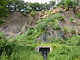
Muttental quarry with the nightingale mine tunnel

Pointed fold in the Hagen-Vorhalle quarry

Rock Sea Hemer

Geological Garden Bochum

Geological outcrop in Schiffswinkel (Herdecke)


_02_ies.jpg)

The importance of raw materials for the development of the region

In particular, the importance of naturally occurring mineral resources for the development of the region played a central role in the recognition of the Ruhr Area GeoPark. There is hardly a region in Germany, where the dependence of economic and cultural development of the raw material - deposits can be seen as clearly as in the Ruhr. Ultimately, today's Ruhr Metropolitan Region owes its existence primarily to the coal mining industry , but also to the occurrence of other important raw materials such as ores , salt , earth and stone minerals.
geology
The geology of the Ruhr area is not limited to the carboniferous seabed : Excellent outcrops make the geological history from the Devonian to the Permian and from the Cretaceous to the present day vivid. There are numerous good geological outcrops that give the visitor an insight into the structure of the subsurface. The North Rhine-Westphalia geotope cadastre lists around 400 objects for the Ruhr area, around 70 to 100 of which can be classified as significant or valuable, some of the outcrops (e.g. the former quarry in Hagen-Vorhalle with its unique finds of Carbon Age insects) are geotopes of European standing. The geological excursion guides already published show the way to many of these outcrops and are continuously updated. There is also an overview map with the most important geotopes.
Geopark information centers

In October 2014, a Geopark Information Center was opened in the premises of the LWL-Industriemuseum Zeche Nachtigall , which provides information about the geology, raw materials in the Ruhr area and the Muttental National Geotope . A second GeoPark information center with a focus on caves and karsts opened in December 2015 in Ennepetal in the immediate vicinity of the Klutert cave . A third center is in the planning stage, which is to be set up after a renovation in the Prussian Museum in Wesel .
Cooperation of the GeoPark
Today the GeoPark forms a network of around 150 members, which includes city administrations, universities, museums, nature conservation organizations and mining history associations as well as current raw materials companies as well as numerous individuals. The successful implementation of all previous projects of the GeoPark Ruhrgebiet could only be achieved with the help of the great interest and commitment of its members.
literature
- Thomas Kirnbauer, Wilfried Rosendahl, Volker Wrede: Geological excursions in the National GeoPark Ruhr Area. Essen 2008. Color photos, maps, tables. (Supplement. Special Dr. From "Annual reports and communications of the Upper Rhine Geological Association", NF 90)
Web links
- http://geopark.metropoleruhr.de/geopark.html
- http://www.nationaler-geopark.de
- http://www.wanderwegewelt.de/blog/mehrtagestouren/georoute-ruhr-hauptroute/
Individual evidence
- ↑ Metropolis Ruhr: Nationaler GeoPark Ruhrgebiet ( page no longer available , search in web archives ) Info: The link was automatically marked as defective. Please check the link according to the instructions and then remove this notice. , accessed on May 10, 2017
- ^ Vera Mügge-Bartolovic: GeoRoute Ruhr. Through the valley of black gold . Regionalverband Ruhr & GeoPark Ruhrgebiet eV (Ed.), Essen 2010, ISBN 978-3-932165-93-1 , 112 pp.
- ↑ Geopfad Kaisberg with the descriptions of the information boards ( Memento of the original from August 7, 2014 in the Internet Archive ) Info: The archive link was automatically inserted and not yet checked. Please check the original and archive link according to the instructions and then remove this notice. , accessed January 30, 2013
- ↑ GeoRoute Lippe - Homepage , accessed on May 9, 2017
- ↑ GeoRoute Lippe at GeoPark Ruhrgebiet , accessed on May 9, 2017
- ^ Andreas Abels: GeoRoute Lippe. From iron stones, dune fields and meanders of the Lippe - through the north of the GeoPark Ruhrgebiet . Regionalverband Ruhr & GeoPark Ruhrgebiet eV (Ed.), Essen 2017, ISBN 978-3-939234-23-4 , 118 pp.
- ↑ Günter Drożdżewski, Volker Wrede: 450 years coal mining in the Ruhr . In: Ernst-Rüdiger Look, Ludger Feldmann (Ed.): Fascination Geology. The important geotopes of Germany , E. Schweizerbart'sche Verlagsbuchhandlung, Stuttgart 2006, ISBN 3-510-65219-3 , pp. 52-53
- ↑ Volker Wrede: Rock folds and insects of world renown . In: Ernst-Rüdiger Look, Ludger Feldmann (Ed.): Fascination Geology. The important geotopes of Germany , E. Schweizerbart'sche Verlagsbuchhandlung, Stuttgart 2006, ISBN 3-510-65219-3 , pp. 50–51
- ↑ Volker Wrede: Bizarre landscape full of puzzles . In: Ernst-Rüdiger Look, Ludger Feldmann (Ed.): Fascination Geology. The important geotopes of Germany , E. Schweizerbart'sche Verlagsbuchhandlung, Stuttgart 2006, ISBN 3-510-65219-3 , pp. 44-45
- ↑ waz.de: Geopark Info Center on the Witten Nightingale colliery - October 17, 2014 , accessed on October 26, 2014
- ↑ Geopark Ruhrgebiet: Info Center Geopark Ennepetal , accessed on May 10, 2017
National and UNESCO Global Geoparks: Bergstrasse-Odenwald | Harz - Braunschweiger Land - Ostfalen | Muskauer fold arch | Swabian Alb | TERRA.vita | Vulkaneifel
Other national geoparks: Bavaria-Bohemia | Ice age land on the edge of the Oder | Frontier Worlds | Inselsberg - Three equals | Kyffhäuser | Laacher See | Porphyry Land | Ries | Ruhr area | Westerwald-Lahn-Taunus
Former National Geoparks: Mecklenburg Ice Age Landscape | Eifel volcanic land
Coordinates: 51 ° 25 ′ 43.6 " N , 7 ° 18 ′ 47.8" E