
City of Güntersberge
|
City of Güntersberge
Harzgerode city
|
|
|---|---|
 |
|
| Height : | 412 m above sea level NN |
| Area : | 32.73 km² |
| Residents : | 651 (Dec. 31, 2019) |
| Population density : | 20 inhabitants / km² |
| Incorporation : | August 1, 2009 |
| Postal code : | 06493 |
| Area code : | 039488 |
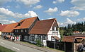
.jpg) View from the east of Güntersberge
|
|

City of Güntersberge is a district of the city of Harzgerode in the Harz district and low mountain range . Güntersberge has been a state-approved resort since April 4, 2001 . Güntersberge was an independent town until it was incorporated on August 1, 2009 .
geography


.jpg)

Güntersberge is located in the upper Selketal directly on the B 242 .
To the north-west of the village lies the early modern desert of Selkenfelde in the Selke Valley .
The Selketalstieg leads through the village , from which the Bode-Selke-Stieg branches off.
Local division
In addition to the actual location of Güntersberge (651 inhabitants), the settlements Friedrichshöhe (41 inhabitants) and Bärenrode (21 inhabitants) belong to the district. (Residents as of 2019)
Waters
At the western entrance to the village is the mountain lake , a former mill pond that dammed the Selke. With its water surface of around 8 hectares, the pond is used for swimming and rowing.
A little to the southwest of the village is the Katzsohlteich , which dams the Katzsohlbach , which is mostly in the Güntersberge district and is a tributary of the mountain lake. The Limbach flows north of Güntersberge, which is dammed in the Brauteich in the locality and flows into the Selke on the left. Several other small brooks flow in the area - some of them dammed in tiny, mostly nameless ponds. The Hofteich is located near the eastern exit of the village . The largest reservoir of these is the Ellerteich , about 1.5 km west of the village - with a dam length of 60 meters and 50 acres . To the west of the Friedrichshöhe district, the Steigerbach flows , which mostly flows within the Güntersberge district, but flows into the Selke just outside the district. The district of Bärenrode is located in the headwaters of the Steinfurtbach , which in the Güntersberge district near Bärenrode is dammed for the first time in the 55- arre Bärenröder pond . Shortly before the mouth, the stream is dammed again in the much larger Elbingstalteich .
history
In 1179, a place called Alten Torp is mentioned as the property of the Propstei Hagenrode , and in 1281 a Ghuntersberg is located next to it in a deed of purchase from the Quedlinburg Marienkloster . Both settlements grew together to form a place that was first referred to as a city in 1437. Due to its convenient location on a busy trade route, the place experienced a rapid upswing. As early as 1326, the princes of Anhalt owned a palace here and thus probably also Güntersberge and its surroundings. Güntersberge was pledged several times, in particular to the Counts of Stolberg , who had to return the city to the Princes of Anhalt in 1536. In the privileges granted in 1539, a brewery, a baking house, a malt house and a bath house are mentioned as municipal property . After a division of the country in 1546, Güntersberge was under Prince Georg III. from Anhalt .
Around 1563, 750 inhabitants lived in Güntersberge in around 95 houses. In 1597/98 Güntersberge had 900 inhabitants. This was before the time of the plague, which also claimed its victims here. Most likely, the strong population growth is due to mining activities in the area. Around 1600 the Anhalt princes owned a Vorwerk ( domain ) with a sheep farm in Güntersberge , which existed until the last third of the 19th century. A customs post is mentioned for the first time around 1600 on the Harz high road crossing the town. The town bought the property of the von Bila (Bilaw) family from the two manors in the village in 1557. The second estate, originally in the hands of the Mariental / Helmstedt monastery , was acquired by Vogt Bartel Hane in 1506, and in 1571 it went to Hans von Knedlingen, the governor of Harzgerode and Güntersberge. This property was first called Aldendorp, then Altenberg and after Prince Friedrich von Anhalt-Harzgerode bought it and his son Wilhelm declared it the Wittum's residence of his first wife, it was named Albertinenberg after her name.
After the division of the country in 1603/06, the office of Güntersberge, which after the desolation of some small villages consisted only of the city and, together with the office of Harzgerode, was subordinate to an official governor or later judiciary, belonged to the Principality of Anhalt-Bernburg .
After the destruction and losses as a result of the 30-year war, 390 residents still lived in Güntersberge, spread over 60 houses. From 1635 to 1709 it was part of the Principality of Anhalt-Harzgerode, which was separated from Bernburg. In 1753, the Güntersbergers defended themselves against the conversion of community forests into state ownership and increasing burdens from the rule of Prince Viktor Friedrich (Anhalt) in an uproar that forced concessions from the Prince. In 1758 the residents rebelled against the demand for a delivery of flour and forage for the Prussian army, which resulted in heavy penalties. In 1735 the town had 135 houses, in 1833 142 with 839 inhabitants and in 1900 934 people were distributed over 216 households. At this time Friedrichshöhe, founded as a "colony" in 1781, had long belonged to the town of Güntersberge. Güntersberge suffered to a great extent from fires over the centuries, which destroyed large parts of the city, for example in 1538, 1630, 1659, 1707 and 1856.
In 1887 Güntersberge had a connection to the German railway network via the Selketalbahn . In 1888 the local volunteer fire brigade and, on the initiative of Mayor Keil, the Harzklubzweigverein were founded. The employment opportunities, which were previously limited to agriculture, forestry and handicrafts, were expanded through the establishment of a number of businesses such as a match factory, a sawmill and a branch of the Eisfeld company, and powder and pyrotechnic factories in Silberhütte. In 1924 the place received electric light and in 1929 water pipes instead of fountains. In 1930 the school building, which is still in Burgstrasse today, was built for teaching four classes. A twist drill and machine tool factory, which had existed since 1935, employed 600 workers under wartime conditions, including more than 100 women and men during the Second World War , who were deported from the Soviet Union to Germany and who performed forced labor in the armaments production of the Stock factory .
After a brief occupation by US troops from April 14, 1945, the Red Army invaded the area on June 2 and thus became part of the Soviet occupation zone. Under GDR conditions, a machine lending station for agriculture (MAS) was set up in 1951 , from 1952 the collectivization and establishment of the LPG "Karl Marx" followed, in 1975 establishment of a KAP ( Cooperative Plant Production Department ). An electric furnace and plant construction was relocated to the former Stock'sche factory. A few blocks of flats were built for the population, which had grown to 1238 people by 1980, and a larger school building on Stolberger Weg in 1990/91. During the GDR times, one of the first central pioneer holiday camps " Werner Seelenbinder " of the pioneer organization "Ernst Thälmann" was located in the place , in the place of which the KiEZ (Children's and Recreation Center Güntersberge eV) was founded in 1992.
After the end of the GDR and the reunification of Germany, they entered into a partnership with Bockenem , an agricultural cooperative, the tourist association, and Güntersberge joined the Harzer Verkehrsverband. The Harzklubzweigverein was also founded again. In 1994 it became part of the Unterharz administrative community . In 2004 the secondary school had to be closed due to insufficient number of pupils. Including the districts of Friedrichshöhe and Bärenrode, the number of inhabitants was only 698 at the end of 2016.
On August 1, 2009, the town of Güntersberge merged with the town of Harzgerode and the communities of Dankerode , Königerode , Schielo , Siptenfelde and Straßberg to form the new town of Harzgerode.
On July 1, 2014, the new municipal constitutional law of the state of Saxony-Anhalt came into force. In its §14 (2) the municipalities are given the opportunity to assign this designation to the districts that were towns before the incorporation. The city of Harzgerode has made use of this regulation. In its main statute, valid in 2017, the districts are listed with their official names in §1 (2).
- Historical monuments
- VVN -Gedenkstein on a common grave of the cemetery for 20 Soviet men and women during the Second World War, victims of forced labor were
- Memorial on the Giersberg for six unknown Soviet forced laborers
- War cemetery with communal tombstone for 15 German soldiers who died in April 1945, one of them “unknown”.
politics
coat of arms
The coat of arms was approved on December 9, 2004 by the Magdeburg Regional Council.
Blazon : “In silver, a tinned red city wall with an open gate, behind it two slender, tinned red towers with pointed roofs and golden knobs; on the wall between the towers an erect black bear with a gold collar and crown, silver reinforcement and red tongue grows. "
The colors of the city are red - silver (white).
The coat of arms was created around the 15th century. Walls and towers indicate a fortification or castle, remains of which can still be seen today on the Gierskopf, a nearby wooded hill. The bear was the heraldic animal of the Anhalt princes and indicates that they belonged to the principality of Anhalt.
flag
The flag of the town of Güntersberge was approved by the district on June 5, 2008.
The flag is striped red and white (1: 1) (lengthwise: stripes running vertically) and centered with the city coat of arms.
traffic
In addition to some regional lines of the Harz transport company , the Selketalbahn , for which the Güntersberge station is here, also stops in the village .
Culture and sights
The cultural monuments of the place are listed in the local monument register .
Historic Buildings
The Güntersburg castle ruins are known and the subject of many legends , but only remains of the wall have survived. The Schwarzer Bär inn , which has been documented in documents since 1509, is located in Güntersberge .
church
The St. Martini Church bears the name of St. Martin of Tours . The current building was completed after a fire in 1871. Only the portal on the north side of the previous building has been preserved. In the 1970s, the furnishings of the church underwent major changes.
Museums
Mousetrap and curiosity museum
The Mousetrap and Curiosity Museum has a collection of mousetraps, chamber pots, and other curiosities.
School museum
The school museum is located in the old school adventure house and has been dedicated to the school in Güntersberge since the Reformation. There are also other exhibitions, a model railway system and a library there.
The Mousetrap Museum

Exterior view of the school museum

Interior view of the school museum


Personalities
The theologian Johann August Rienäcker (1779–1859), the artist Karl Hagedorn (1922–2005) and the stage designer and director Axel Manthey (1945–1995) were born in Güntersberge.
The tenor Karl Heinz Knepper (1945-2014) died in the village.
literature
- Berent Schwineköper (Hrsg.): Handbook of the historical sites of Germany . Volume 11: Province of Saxony Anhalt (= Kröner's pocket edition . Volume 314). 2nd, revised and expanded edition. Kröner, Stuttgart 1987, ISBN 3-520-31402-9 , pp. 164-165.
- Walter Garscha (editor): Güntersberge 1281–1981. A small Harz town introduces itself. Edited by the City Council of Güntersberge, 1981.
- 725 years Güntersberge / Harz. 1281-2006. Published by City of Güntersberge 2006.
- Edgar Presia: History and stories of the Güntersberge-Hasselfelde branch line. (= Harzgeroder booklets. 1). 1992.
- Bernhard Tänzer: History of fire protection and the fire service organization of the Harzgerode unified community. (= Harzgeroder booklets. 9). 2016.
- Karl-Heinz Börner : The offices of Harzgerode and Güntersberge between the Reformation and the Thirty Years War. (= Harzgeroder booklets. 10). 2017, ISBN 978-3-942975-19-3 .
Web links
- Güntersberge
- Link catalog on Güntersberge at curlie.org (formerly DMOZ )
Individual evidence
- ↑ Susanne Thon: More immigrants again . In: Mitteldeutsche Zeitung . Quedlinburger Harzbote. January 15, 2020, p. 9 .
- ↑ Güntersberge.info - key data , accessed on April 12, 2018.
- ↑ Saxony-Anhalt-Viewer: official topographical map of Saxony-Anhalt (TK 1:10 000 color), district boundaries
- ↑ key data. In: Güntersberge.info. Veronika Zabel, accessed April 12, 2018 .
- ↑ StBA: Area changes from January 2nd to December 31st, 2009
- ↑ Local constitution law of the state in the version of July 1, 2014
- ↑ Main statute of the city of Harzgerode in the version 2017
- ↑ Official Journal of the District No. 7/2008 Page 18 ( Memento of the original from January 8, 2014 in the Internet Archive ) Info: The archive link was inserted automatically and has not yet been checked. Please check the original and archive link according to the instructions and then remove this notice.

Alexisbad with Hänichen and Klostermühle | Dankerode | City of Güntersberge with Bärenrode and Friedrichshöhe | Harzgerode | Koenigerode | Mägdesprung | Neudorf | Squint | Silberhütte | Siptenfelde | Straßberg with Lindenberg