Helbra
| coat of arms | Germany map | |
|---|---|---|

|
Coordinates: 51 ° 33 ' N , 11 ° 29' E |
|
| Basic data | ||
| State : | Saxony-Anhalt | |
| County : | Mansfeld-Südharz | |
| Association municipality : | Mansfeld Grund-Helbra | |
| Height : | 236 m above sea level NHN | |
| Area : | 9.26 km 2 | |
| Residents: | 3986 (Dec. 31, 2019) | |
| Population density : | 430 inhabitants per km 2 | |
| Postal code : | 06311 | |
| Area code : | 034772 | |
| License plate : | MSH, EIL, HET, ML, SGH | |
| Community key : | 15 0 87 205 | |
| LOCODE : | DE ZAH | |
| Address of the municipal administration: |
At the hut 1 06311 Helbra |
|
| Website : | ||
| Mayor : | Alfred Böttge ( SPD ) | |
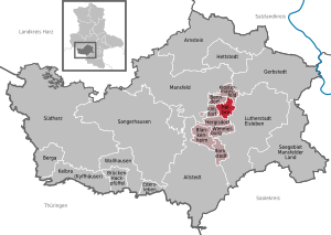
| Location of the community of Helbra in the district of Mansfeld-Südharz | ||
Helbra is a municipality in the district of Mansfeld-Südharz in Saxony-Anhalt . The municipality is the administrative seat of the Verbandsgemeinde Mansfelder Grund-Helbra .
geography
Geographical location
Helbra is about seven kilometers northwest of Lutherstadt Eisleben and about six kilometers southeast of Mansfeld .
Expansion of the municipal area
Helbra is a relatively small municipality with its 9.26 km², due to this small size and the larger extent of the village Helbra it has a medium-high degree of urbanization. By far the largest share of the area of the municipality has arable land and fields, followed by the share of settlement area. Another corresponding proportion is covered by forest area. The exact numbers can be found in the table below. The proportion of the water surface is small, since apart from a few rivulets, which were not counted, there is only one small body of water.
| Area according to type of use |
Total area in ha |
Share in the area of the municipality |
|---|---|---|
| Settlement area | 316.9 | 34.5% |
| Forest and meadows | 106.3 | 11.6% |
| Fields and fields | 502.8 | 52.6% |
| Water surface | 6.3 | 0.7% |
Source : geoportal.de, the information is freely measurable.
Neighboring communities
Neighboring communities are Klostermansfeld and Benndorf in the north, Lutherstadt Eisleben in the east, Hergisdorf in the south and Ahlsdorf in the west.
history
The community was first mentioned in a document in 1155.
The name of the place was probably due to its location between Mansfeld and Eisleben. At this point you had made half the distance and also the ascent from Eisleben through the thieves' chamber. So you were halfway to your goal, in Mansfeld dialect “helb ra”. This is how the place name came about, the place itself is now called "Hälwer" in Mansfeld dialect.
Helbra's history over the past 150 years was very much shaped by industrialization ( ironworks , copper slate mining , mining railway ). Hardly anything of that can be seen today; only those familiar with history can explain the traces. The regional specialist literature on this subject is informative. After termination and relocation in the direction of Sangerhausen, the industry is in decline. The largest operation was the August-Bebel-Hütte , the largest and last raw copper smelter in the GDR (probably also in Germany). Here the ore from the Mansfeld pits, which mostly contained just 1.5% copper, was processed into raw copper stone (approx. 60% copper). This was then processed into the purest copper in Hettstedt (formerly the copper-silver smelter). At the turn of 1990 the hut was closed. A landmark of Helbra, the Lange Heinrich (the approx. 90 m high chimney), was also blown up.
A tram line, the so-called union railway, ran between Eisleben and Hettstedt until 1922. The flat connection across the Grunddörfer allowed this route. This connection was discontinued in 1922 due to high maintenance costs. Today only the embankments between Ziegelrode and Helbra and between Helbra and Klostermansfeld (Sommerweg) are reminiscent of this tram route. The only remaining bridge is in the area of the Neptun-Bad in Helbra (passage to the gas station).
politics
Municipal council
According to the local elections on August 30, 2009, the municipal council consists of 16 people. The local elections in 2009 led to the following result with a turnout of 37.5%:
| Party / list | Share of votes | Seats | + / - |
| CDU | 36.2% | 6th | - 1 |
| FWH | 20.6% | 3 | + 2 |
| The left | 20.1% | 3 | ± 0 |
| SPD | 17.9% | 3 | ± 0 |
| Individual applicants | 5.2% | 1 | ± 0 |
mayor
The honorary mayor Alfred Böttge was elected for the first time on June 26, 1994; he was confirmed in office in 2001, 2008 and 2015.
coat of arms
The coat of arms was approved on July 22, 1993 by the Halle regional council.
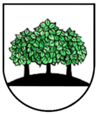
Blazon : "In silver, on a black floor, three green linden trees with a black trunk, the middle linden tree partially covering the sides."
flag
The flag of the municipality of Helbra shows the colors green - silver (white).
Town twinning
A partnership has existed since 1990 with the municipality of Finnentrop from North Rhine-Westphalia .
Culture and sights
Museums
- Homeland and mining nature trail , with a Malakow tower and the still intact Schmidschacht.
Buildings
- The Protestant St. Stephen's Church with a 1000 year old tower and a remarkable inner entrance door: this is not cut to size with a saw, but healed.
- Evangelical rectory.
- Remains of mining facilities such as the Schmid shaft
- The Catholic Church of St. Barbara .
- Bad Anna and Neptunbad
Regular events
The brass music festival of the Mansfeld region takes place every 2 years on the last weekend in June. In the years in between, the summer festival is celebrated on Bad Anna.
Economy and Infrastructure
traffic
- To the federal highway 180 , which connects Eisleben and Hettstedt , it is 4 km to the east.
- Helbra is on the Berlin – Blankenheim railway line . From here, trains ran over the Wipperliese to Wippra until mid-2012 ; however, since mid-2012 the trains have only been running between Klostermansfeld and Wippra. Passenger trains no longer stop in Helbra.
- In Helbra is the intersection of the important historical trade route between Eisleben via the thieves' chamber (steep and winding ascent) via Klostermansfeld to Hettstedt and the connection between Volkstedt via the Grunddörfer via Wimmelburg to Eisleben.
Personalities
Sons and daughters of the church
- Wilhelm Spielberg (1826–1890), member of the Reichstag and Landtag
- August Hermann Spielberg (1827–1886), architect
- Robert Eimler (1891–1960), major general
- Heinz Schwitzke (1908–1991), author and editor
- Paul Steinbrück (1911–1994), physician
- Fritz Schenk (1930–2006), publicist and journalist
- Rolf Dach (* 1934), youth functionary (FDJ) and GDR diplomat
- Dieter Montag (* 1949), actor
- Norbert Bischoff (* 1950), SPD politician, 1994–2016 Member of the State Parliament in Saxony-Anhalt
Town twinning
a communal partnership exists
-
 Finnentrop in North Rhine-Westphalia , Germany
Web links
Individual evidence
- ↑ State Statistical Office Saxony-Anhalt, population of the municipalities - as of December 31, 2019 (PDF) (update) ( help ).
- ↑ Maps . Federal Agency for Cartography and Geodesy. Retrieved May 8, 2019.
- ↑ cf. the private website of the metalworking engineer Rolf Rische (and Karl-Heinz Sommereisen †)
- ↑ State Statistical Office Saxony-Anhalt
- ↑ http://www.stala.sachsen-anhalt.de/wahlen/bm15/erg/gem/bm.15087205.20150419.ergtab.dr.html


