
Arnstein (Saxony-Anhalt)
| coat of arms | Germany map | |
|---|---|---|

|
Coordinates: 51 ° 41 ′ N , 11 ° 28 ′ E |
|
| Basic data | ||
| State : | Saxony-Anhalt | |
| County : | Mansfeld-Südharz | |
| Area : | 121.69 km 2 | |
| Residents: | 6553 (Dec. 31, 2019) | |
| Population density : | 54 inhabitants per km 2 | |
| Postal code : | 06456 | |
| Primaries : | 03473, 03476, 034742, 034781, 034785 | |
| License plate : | MSH, EIL, HET, ML, SGH | |
| Community key : | 15 0 87 031 | |
| City structure: | 12 localities | |
City administration address : |
Eislebener Chaussee 2 06456 Arnstein district Quenstedt |
|
| Website : | ||
| Mayor : | Frank Sehnert | |
| Location of the city of Arnstein (Saxony-Anhalt) in the district of Mansfeld-Südharz | ||
  |
||

Arnstein ( ) is the name of a town in the district of Mansfeld-Südharz ( Saxony-Anhalt ), which was created on January 1, 2010. The city is named after the castle of the same name in the district of Harkerode.
geography
The city is the northernmost municipality in the district of Mansfeld-Südharz , it lies between Hettstedt in the south and Aschersleben in the north. The western part of Arnstein lies in the Harz Mountains , the eastern part in the Harz foreland. In the western part the brooks have dug deep, branched and in some places steep valleys. In the eastern part the terrain slopes down to the Wippertal. East of the Wipper it rises again. With good visibility you can from Roda, which is high above Sandersleben , over the entire municipality up to 1141.2 m above sea level. NHN high Brocken , the highest mountain in Saxony-Anhalt. Arnstein's landscape is dominated almost exclusively by fields. Only the western part is forested. In the central part there are only a few, smaller and scattered woods. In addition to the villages that still exist today, there are also desert areas in the city, such as Wolfshagen , Iwerode , Klein Sylda near Sylda and Oberwelbsleben near Welbsleben . To the east, near Sandersleben, are the desert areas Rote Welle and Mummesdorf . The highest mountain in the urban area is the 326 m high Eichberg near Friedrichrode in the extreme southwest of the urban area.
Waters
The largest river in the city is the Wipper , which, coming from the Harz region, flows through the districts of Wiederstedt and Sandersleben . There are more districts on the one that the Wipper flows into, but flows outside of the municipality. These districts are Stangerode , where the Leine flows, Alterode , where the Schwennecke flows, Harkerode , where Mukarehne (left) and Schloßgraben (right) converge, and Welbsleben , where the Langetalbach ends (places arranged in the direction of flow). There is also the Stockbach in the south of the municipality , which flows to Großörner and in the east the Rote Welle , on which the desert of the same name lies.
Neighboring communities
Neighboring communities are Aschersleben ( SLK ) in the north, Könnern ( SLK ) in the east, Gerbstedt , Hettstedt and Mansfeld in the south, and Falkenstein ( HZ ).
history
Arnstein was formed from the voluntary amalgamation of ten municipalities of the administrative community Wipper-Eine . The name of the new unified community is derived from the old Arnstein office .
The merger took place against the background of the municipal area reform in Saxony-Anhalt and the associated dissolution of the administrative community Wipper-Eine in favor of a unified municipality. The area change agreement was signed by ten of the twelve member municipalities. In the municipalities of Arnstedt and Wiederstedt, which formerly belonged to the administrative community of Wipper-Eine, approval for the formation of a unified municipality was pending, so that they were co-administered by the city of Arnstein until September 1, 2010.
Localities and districts
Arnstein consists of twelve localities , corresponding to the dissolved communities:
| Locality | Residents | Districts |
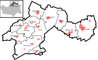 .svg) (clickable map) |
|---|---|---|---|
| Alterode | 517 | Alterode | |
| Arnstedt | 552 | Arnstedt | |
| Bräunrode | 447 | Bräunrode, Friedrichrode and Willerode | |
| Greifenhagen | 272 | Greifenhagen | |
| Harkerode | 333 | Harkerode | |
| Quenstedt | 820 | Pfersdorf and Quenstedt | |
| Sandersleben (Anhalt) | 1901 | Roda and Sandersleben | |
| Stangerode | 351 | Stangerode | |
| Sylda | 512 | Sylda | |
| Ulzigerode | 202 | Ulzigerode | |
| World life | 712 | World life | |
| Wiederstedt | 1074 | Wiederstedt |
Infrastructure
traffic

- The only federal road in the city is federal road 180 Wanzleben - Frankenberg , it runs in north-south direction roughly through the middle of the city area and through the district of Quenstedt . This is to be relieved by the planned bypass Aschersleben-Quenstedt. The federal road 242 , which connects Mansfeld with Seesen , runs in the southeast near the city limits.
- The following state roads open up the city: (only the course in the municipality, or the first place outside, is mentioned, if the streets continue is written [...] )
- 72 ([…] - Welfesholz - Sandersleben bypass - Schackenthal - […])
- 152 (Hettstedt - Wiederstedt - Sandersleben - Alsleben (Saale) )
- 158 (crossing at Saurasen (B 242) - Greifenhagen - Meisberg - [...])
- 227 ( Harkerode - Sylda - Willerode - Rödgen - [...])
- 228 ([...] - Tilkerode - Stangerode - Alterode - Harkerode - Welbsleben - Westdorf - [...])
- 229 (Quenstedt - Welbsleben - Ermsleben - [...])
- The city's only train station is in Sandersleben, where the historic railway lines from Halle to Halberstadt and from Berlin to Blankenheim crossed . At present, you can take the Regional Express from Sandersleben to Erfurt , Halle (Saale) , Goslar and Magdeburg without having to change trains. The Südharz transport company opens up the region with buses.
Personalities
- Waltraut Hennig (1921–2015), teacher and politician (LDPD), born in the Greifenhagen district
Individual evidence
- ↑ State Statistical Office Saxony-Anhalt, population of the municipalities - as of December 31, 2019 (PDF) (update) ( help ).
- ↑ http://www.mansfeldsuedharz.de/media/pdf/presse/ab_msh_2009_08_s_32.pdf (link not available)
- ↑ a b StBA: Area changes from January 1st to December 31st, 2010
- ^ Frieder Fahnert: Hope rests on bypassing the town. Mitteldeutsche Zeitung , May 20, 2010, archived from the original on August 4, 2012 ; Retrieved May 26, 2010 .
Web links
Ahlsdorf | Allstedt | Arnstein | Benndorf | Berga | Blankenheim | Bornstedt | Bridge minced puffle | Edersleben | Gerbstedt | Helbra | Hergisdorf | Hettstedt | Kelbra (Kyffhäuser) | Klostermansfeld | Lutherstadt Eisleben | Mansfeld | Sangerhausen | Lake Mansfelder Land | South Harz | Wallhausen | Wimmelburg