
Stangerode
|
Stangerode
City of Arnstein
|
|
|---|---|
 |
|
| Height : | 203 m above sea level NHN |
| Area : | 9.65 km² |
| Residents : | 351 (Dec. 31, 2008) |
| Population density : | 36 inhabitants / km² |
| Incorporation : | January 1, 2010 |
| Postal code : | 06456 |
| Area code : | 034742 |
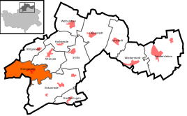 .svg) Location of Stangerode in Arnstein
|
|
 View of Stangerode
|
|
Stangerode is a district of the town of Arnstein in the district of Mansfeld-Südharz in Saxony-Anhalt . In 2009 Stangerode became a state-approved resort .
geography
Stangerode is located on the eastern edge of the Harz, about 13 km southwest of Aschersleben . In the center which opens leash in the One .

history
Stangerode was first mentioned in a document as Stangerod in 1216 . According to a popular custom that was widespread earlier, the legend of the cowl interest is rooted here. The place was in the pledged Saxon office of Arnstein and came to the Kingdom of Prussia in 1815 .
On January 1, 2010, the previously independent communities of Stangerode, Alterode , Bräunrode , Greifenhagen , Harkerode , Quenstedt , Sylda , Ulzigerode and Welbsleben and the city of Sandersleben (Anhalt) merged to form the new city of Arnstein. The administrative community Wipper-Eine , to which Stangerode belonged, was dissolved.
coat of arms
Blazon : "A red stone in gold, accompanied by two green, rooted deciduous trees."
The landmark of Stangerode is the so-called "murder stone", on the site of which, according to legend, a monk was murdered in the distant past. An earlier seal already shows this stone between two deciduous trees. In 1995 the municipality decided to include the stone and the two deciduous trees in the town's coat of arms. The coat of arms was designed by the Magdeburg municipal heraldist Jörg Mantzsch .
Economy and Infrastructure
The economic basis of the community is tourism and agriculture and forestry.
traffic
To the federal highway 242 , which connects Hasselfelde and Mansfeld , it is approx. 11 km southwards. State road 228, which connects Aschersleben with Abberode , runs through the village .