Leash (one)
|
Leine Stanger or Leine |
||
|
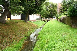
the line in Stangerode, a few meters from its mouth |
||
| Data | ||
| location | Saxony-Anhalt | |
| River system | Elbe | |
| Drain over | A → Wipper → Saale → Elbe → North Sea | |
| source | southeast of Harzgerode 51 ° 37 ′ 32 ″ N , 11 ° 9 ′ 51 ″ E |
|
| Source height | approx. 415 m above sea level NN | |
| muzzle | in Stangerode in the one coordinates: 51 ° 39 ′ 30 ″ N , 11 ° 21 ′ 22 ″ E 51 ° 39 ′ 30 ″ N , 11 ° 21 ′ 22 ″ E |
|
| Mouth height | approx. 200 m above sea level NN | |
| Height difference | approx. 215 m | |
The Leine is a left tributary of the Eine in the Harz Mountains , in Saxony-Anhalt . To distinguish it from the somewhat larger tributary of the same name, the Helme and the much larger Leine zu Aller , it is also called Stanger or Leine , after its point of mouth.
course
Two places are considered as the origin of the line:
- From a hydrographic point of view, it begins with a pseudobifurcation as the eastern part of a drainage ditch that runs south of Harzgerode over a saddle of the ridge that runs further northeast into the Schiebecksköpf . The point is less than half a kilometer north of the Source of the One .
- After 560 m the water reaches its second source, a strong spring, through the hollow of which it is guided by dams.
The Leine initially flows in a north-easterly direction and moves so far away from the one that there is still space for Wiebeck between the two valleys . Between Molmerswende am Wiebeck and Pansfelde on the Schwennecke , which flows parallel to the north, the Leinemühle stands south of the Leineberg (330 m) in its otherwise uninhabited valley. In Stangerode the line joins one .
