High horror
| High horror | ||
|---|---|---|
| Highest peak | Wetzelshain ( 370.1 m above sea level ) | |
| location | Districts of Kyffhäuser and Sömmerda ( Thuringia ), Burgenlandkreis ( Saxony-Anhalt ) ( Germany ) | |
| part of | Lower Unstrut mountain and hill country , Thuringian Basin (with edge plates) | |
| Classification according to | Handbook of the natural spatial structure of Germany | |
|
|
||
| Coordinates | 51 ° 15 ′ N , 11 ° 20 ′ E | |
| rock | Red sandstone | |
| surface | 30 to 55 km² depending on the definition | |
The Hohe Schrecke is a depending on the definition (see section in the Finne article ) up to 370.1 m above sea level. NHN high and 30 to 55 km² mountain range in the districts of Kyffhäuser and Sömmerda in Thuringia , which on some maps extends into the Burgenland district ( Saxony-Anhalt ).
geography
location
The Hohe Schrecke in the broader sense lies between Bretleben and Reinsdorf in the north, Gehofen , Nausitz and Donndorf in the northeast, Langenroda , Garnbach , Wiehe and Allerstedt in the east, Lossa in the southeast, Hauteroda , Oberheldrungen and Heldrungen in the west and Braunsroda in the northwest.
The near-surface geological subsurface of the Hohe Schrecke is formed by the rocks of the red sandstone and a layer of loess .
To the northwest, north and northeast, the Hohe Schrecke is surrounded by the Saale tributary Unstrut .
Mountains and elevations

The highest elevation of the Hohe Schrecke in the broader sense is the Wetzelshain ( 370.1 m ). Its mountains and elevations include - sorted by height in meters (m) above sea level (MSL; unless otherwise specified according to):
- Wetzelshain (370.1 m), between Hauteroda and Garnbach
- Beerberg (362.7 m), between Hauteroda and Langenroda
- Drei-Lindenberg (357.6 m), near Garnbach
- Seligenbornsberg (356.0 m), near Lossa in the transition area to the Finne in Saxony-Anhalt
- Erbsland (353.6 m), near east amondra in the transition area to the Finn
- Heidenkopf (353.2 m), between Garnbach and Ostramondra
- Buchberg (348.6 m), near Langenroda
- Bilsenhügel (341.3 m), between Hauteroda and Donndorf
- Mittelberg (337.2 m), near Garnbach
- Eichleite (328.6 m), between Hauteroda and Donndorf
- Schulzenberg (319.6 m), between Gehofen and Oberheldrungen
- Heidelberg (267.6 m), near Braunsroda
- Schlachtberg (237.0 m), near Gehofen
- Kummerberg (231.3 m), near Reinsdorf
- Querberg (195.8 m), near Reinsdorf
- Leidenberg (186.1 m), near Bretleben
→ for these and other Thuringian mountains and elevations of the Hohe Schrecke see list of mountains and elevations in Thuringia # Hohe Schrecke
history
The Hohe Schrecke belonged to the core area of the Thuringian Kingdom and had mighty ramparts and fortifications (e.g. the Monraburg ) in the peripheral areas . In the High Middle Ages, the area belonged to the sphere of influence of the Beichlinger Counts, the Counts of Wiehe and the Thuringian Landgraves ( Raspenburg ). The roads running through the area were controlled by other castles, one of which was Rabenswalde Castle . The economic development and the development of the country also led to the establishment of settlements and villages in the interior of the mountains, the Wetzelshain desert testifies to this . Until the non-compensated expropriation in 1945 was one of 4,900 hectares of the family of the main part of the forest of Werther-Beichlingen .
In the 1930s, an ammunition plant for the German Air Force was built in the eastern part of the Hohe Schrecke, east of Lossa . Above-ground bunkers with an embankment were used to store the ammunition . These were blown up in 1945 by the Red Army , and the ammunition stocks were disposed of mainly in former potash pits.
Between 1946 and 1948 the Soviet occupying forces cleared 2,000 of the 4,900 hectares of forest for a military training area , surrounded by a restricted military area. Sometimes the forest was allowed to grow back. At the beginning of the 1990s, the Soviet troops who were based near Lossa were withdrawn. The LEG Thüringen received to clean the area of ammunition the order, as well as missile bays and close bunker. 3,000 hectares have not yet been safely cleared (2010). After that the forest should be sold. Later the decision was made for the large-scale nature conservation project “Hohe Schrecke - Old Forest with a Future” (see section Protected Areas ).
Flora and fauna
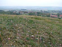
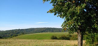
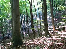
The landscape on the Hohe Schrecke is characterized by large, closed and uncut deciduous forests, especially beech forests. In the south-eastern part of the border between the two federal states there are areas that served as military training areas until the Soviet Army withdrew and were kept free of forests for this purpose. The forest areas usually merge directly with the intensively cultivated arable land at their edges. In places, however, they are also interlocked with, in some cases, large orchards and brisk semi-dry lawns .
Due to its closeness, the Hohe Schrecke offers a habitat for wild cats , black storks and red deer . More than 500 different types of large mushrooms also grow here.
Protected areas
A large part of the Hohe Schrecke was designated as a nature reserve Hohe Schrecke ( CDDA no. 329442) in 2004 . It covers an area of 34.593 km² (according to other information 34.37 km²) and was reported to the European Commission as part of the fauna-flora-habitat area Hohe Schrecke-Finne (FFH no. 4734-320; 57.32 km²) extends into landscapes that were previously attributed to the Finns. The bird sanctuary Hohe Schrecke-Finne (VSG no. 4734-320; 57.32 km²) is congruent with the FFH area .
The major nature conservation project "Hohe Schrecke - Old Forest with a Future" was recognized as one of five winners of the federal competition for major nature conservation projects and rural development, "idee.natur - Nature Conservation Future Prize". Funding from the Federal Ministry of Agriculture and Forestry, Environment, Nature Conservation and Nuclear Safety and the Federal Ministry of Food, Agriculture and Consumer Protection were made available for this purpose.
literature
- Hohe Schrecke - Old Forest in "idee.natur - Future Prize for Nature Conservation". Ed. BM for the Environment, Nature Conservation and Nuclear Safety and Federal Agency for Nature Conservation, Bonn, 2009
- Hoard of beeches: More space for nature . In: GEO 03/2008, p. 174 (anonymous report with the request to declare the Hohe Schrecke a national park)
Web links
- Hohe Schrecke - old forest with a future ( memento from December 23, 2015 in the web archive archive.today ), on idee-natur.de
- Map / aerial photo of the north-eastern boundary of the Thuringian Basin with the Hohe Schrecke (kmz, 10 kB)
- Nature conservation project area 4 "Hohen Schrecke-Finne" , on thueringen.de
- Hohe Schrecke - large nature conservation project , on naturschutzprojekt.hoheschrecke.de
Individual evidence
- ↑ a b c d e f Map services of the Federal Agency for Nature Conservation ( information )
- ↑ Official topographic maps of Thuringia: LK Sömmerda, Ilmkreis, district-free city of Erfurt . In: Thuringian Land Survey Office (Hrsg.): CD-ROM series Top10 . CD 3. Erfurt.
- ↑ Dr. Dierk Conrady / Foundation "David" / Hohe Schrecke: on May 19, 2010 in Erfurt.
- ↑ Hohe Schrecke (NSG 375) (and other nature reserves) in: Nature reserves ... in the district of Sömmerda. Thuringian State Institute for Environment and Geology (TLUG), June 2011, accessed on April 13, 2011 : "The NSG comprises a large, complex, very structurally rich, large-scale and uncut mixed beech forests (including woodruff-beech forests, grove-sessile oak-mixed forests, Winkelseggen-alder- Ash forests) with a remarkable range of species. It also represents a particularly valuable reproduction area for the wild cat. "


