
Sömmerda district
| coat of arms | Germany map |
|---|---|

|

Coordinates: 51 ° 10 ′ N , 11 ° 10 ′ E |
| Basic data | |
| State : | Thuringia |
| Administrative headquarters : | Sömmerda |
| Area : | 806.86 km 2 |
| Residents: | 69,427 (Dec. 31, 2019) |
| Population density : | 86 inhabitants per km 2 |
| License plate : | SÖM |
| Circle key : | 16 0 68 |
| NUTS : | DEG0D |
| Circle structure: | 38 parishes |
| Address of the district administration: |
Bahnhofstrasse 9 99610 Sömmerda |
| Website : | |
| District Administrator : | Harald Henning ( CDU ) |
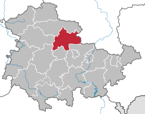
| Location of the Sömmerda district in Thuringia | |
  |
|
The district of Sömmerda is a district in the northeast of Thuringia .
geography
The territory of the district of Sömmerda lies in the area of the central Unstrut in the northeastern part of the Thuringian Basin and extends in an east-west direction from the Finn to the Unstrutstau near Straussfurt and in a north-south direction from the foothills of the Hainleite near Bilzingsleben to the State capital Erfurt. Neighboring areas are the Kyffhäuserkreis in the north, the Saxony-Anhalt Burgenlandkreis in the east, the Weimarer Land district and the district-free city of Erfurt in the south and the Gotha district and the Unstrut-Hainich district in the west .
nature
Nature reserves
There are eight nature reserves in the Sömmerda district . The nature reserves Wipperbruchbruch and Hohe Schrecke are also partly in the Kyffhäuserkreis .
| NSG no. | Name of the area | Natural space | Area (ha) |
|---|---|---|---|
| 15th | Finnberg | 2.2 High scare - jewelry - fin | 72.7 |
| 43 | In the hook | 3.4 Fahner's height | 18.6 |
| 46 | Alperstedter Ried | 6.3 Gera-Unstrut lowland | 101.6 |
| 47 | Schwansee | 5.1 Central Thuringian hill country | 76.8 |
| 60 | Haßleben Ried | 6.3 Gera-Unstrut lowland | 58.7 |
| 71 | Brembach vineyards | 5.1 Central Thuringian hill country | 124.8 |
| 85 | Rocker breakthrough | 3.2 Hainich - Dün - Hainleite | 671.9 |
| 375 | High horror | 2.2 High scare - jewelry - fin | 3459.3 |
Natural park
The Kyffhäuser Nature Park is a small part also in the district of Sömmerda.
history
In 1974 a resting place for prehistoric humans ( Homo erectus bilzingslebenensis ) was found near Bilzingsleben , just on the northern border of the district, which was one of the most important sites in Europe for the period around 400,000 BC. Chr. Counts. The discovery and excavation of the chief grave of Leubing gave rise to the designation of an entire cultural area as the “Leubing culture” (1900–1600 BC). Around 3,000 years ago, people also began in the area of what is now the district to develop dominant elevations into hill fortes. These facilities were sometimes imposing and were used to “rescue”, hide and protect many people, their belongings and, above all, livestock from enemies in times of danger. The Monraburg near Burgenken was particularly important for the region . About 2500 years ago Germanic tribes immigrated from the north. The area of today's Sömmerda district became part of the "Hermundurenland", so named after the name of the Germanic tribal group that was dominant in Central Germany and from which, with the inclusion of other Germanic tribes ( fishing , warning ) around AD 400 The Thuringian people. The area was part of the heartland of the Thuringian Kingdom . With the smashing of this empire in 531 AD, the commissioners of Franconian kings and emperors ruled over the area, administered it, established settlements and promoted the development of the country. Many of today's localities in the district were recorded in documents as early as the 8th and 9th centuries. During this early medieval period, Slavic settlers also immigrated to the region: Thuringians, Franks and Slavs (Wends) merged more and more, cultivated the landscape and expanded their settlement area. Along with the incorporation of Thuringia into the Franconian Empire, the increasing Christianization of Thuringia took place from the 8th century. The landgraves of Thuringia ( Runneburg / Weißensee) and the counts of Beichlingen and Hohenstein were among the most powerful feudal lords of the 9th century . The latter were replaced by the Counts of Schwarzburg in the middle of the 14th century . But the city of Erfurt and the Principality of Mainz had also had territorial ownership in the district since 1418. As a result of the expansion of the state sovereignty, cities came into being - arable towns whose economic life was particularly strongly influenced by agriculture and woad cultivation ("Thuringian gods").
After the Congress of Vienna, the area was reorganized by the state, with the largest part coming to the Kingdom of Prussia in 1815 . The western part of this Prussian area belonged to the Weissensee district and the eastern part to the Eckartsberga district . After the Thuringian royal houses abdicated in 1918 and the state of Thuringia was formed, the communities that had previously belonged to the Grand Duchy of Saxony-Weimar-Eisenach were incorporated into the newly formed Thuringian district of Weimar . In 1932 the districts of Weißensee and Erfurt were merged to form a new district of Weißensee. In 1945 it was incorporated into the state of Thuringia . In 1950 the district of Weissensee was dissolved and a large part of the newly formed district of Erfurt-Land ; the Saxony-Anhalt district of Eckartsberga was renamed the district of Kölleda. With the reorganization in 1952 , the Sömmerda district was created , which was assigned to the Erfurt district .
After the reunification of the two German states, the Sömmerda district became the Sömmerda district of the new state of Thuringia in 1990 . During the regional reform in 1994, the district was enlarged to include parts of the former Erfurt-Land district in the south and parts of the former Artern district to the north .
Population development
Development of the population:
| year | population |
|---|---|
| 1994 | 82,667 |
| 1995 | 82,635 |
| 1996 | 82,543 |
| 1997 | 82,483 |
| 1998 | 82,158 |
| 1999 | 81,884 |
| 2000 | 81.204 |
| 2001 | 80,323 |
| 2002 | 79,592 |
| 2003 | 78,671 |
| 2004 | 77,831 |
| 2005 | 76,865 |
| 2006 | 76.097 |
| 2007 | 75,257 |
| 2008 | 74,359 |
| 2009 | 73,688 |
| 2010 | 72,877 |
| 2011 | 72,345 |
| 2012 | 71.005 |
| 2013 | 70,833 |
| 2014 | 70,534 |
| 2015 | 70,600 |
| 2016 | 70.118 |
| 2017 | 70.027 |
| 2018 | 69,655 |
| 2019 | 69,427 |
Data source: from 1994 Thuringian State Office for Statistics - values from December 31st
economy
The image of the Sömmerda district is shaped by an intensively used agricultural landscape. The region around Kindelbrück is a traditional fruit-growing area. Industrialization began after Johann Nikolaus von Dreyse founded the first rifle factory in 1840 in the district town of Sömmerda. In 1901 the Dreysische Gewehrfabrik became a company of the Rheinmetall Group, in 1920 the production of typewriters began and two years later the production of calculating machines. In 1945 the plant developed into the Sömmerda office machine factory with up to 12,000 employees. Numerous companies and institutions have now re-established themselves in the industrial park that was newly created in the area after the fall of the Wall. Computer manufacturers such as Fujitsu Siemens and logatec have also settled in the district, which are now among the largest manufacturers in Europe. The other small towns remained rural, characterized by handicrafts and small industries. In the 19th century, the intensive cultivation of medicinal herbs brought Kölleda the nickname "Peppermint City".
The largest companies in the district are Mubea Fahrwerkfedern in Weißensee with 530 employees, Fujitsu Siemens in Sömmerda with 360 employees, Funkwerk AG in Kölleda with 350 employees, EUT Erdrich Umformtechnik in Sömmerda with 320 employees and MDC Power (Mercedes-Benz engine plant) in Kölleda with 1,400 employees.
The regional trade fair for business in the district of Sömmerda takes place annually under the name SÖM. With the SÖM, the companies, craftsmen and service providers in the district have the opportunity to offer their services and products on a regional level and to talk to consumers and customers on site.
In the future atlas 2016 , the district of Sömmerda was ranked 360 out of 402 districts and independent cities in Germany and is therefore one of the regions with "future risks".
unemployment
Development of the unemployment rate in the district:
|
|
|
|
|
|
traffic
Streets
The district currently has a road network with the federal highways 4 , 85 , 86 and 176 . With the completion of the federal highway 71 in 2015, the traffic development was significantly improved.
railroad
The railway network in the district comprises the south-north connections from Erfurt to Bad Langensalza, Nordhausen and Sangerhausen / Magdeburg as well as the east-west connection Naumburg – Bad Langensalza. The first railway line was opened in the west of the district in 1869 by the Nordhausen-Erfurt Railway Company via Straussfurt. From here the Saale-Unstrut Railway has been running eastwards via Buttstädt to Großheringen since 1874 . Sömmerda became a junction in 1879, here the north-south route of the Magdeburg-Halberstädter railway company from Sangerhausen to Erfurt crosses the Saale-Unstrut railway. The Prussian State Railroad added to the rail network at the turn of the century: in 1897, two municipalities in the south-west corner of the district received stations on the Bad Langensalza-Erfurt line, starting from the Straussfurt junction, a railway line to Bad Tennstedt was added in 1906 and in 1914 a cross connection was established from Kölleda towards Lossa made at the Finne-Laucha. In 1887, the Weimar-Rastenberger Eisenbahn- Gesellschaft led narrow-gauge railways from Weimar to the Sömmerda district, both to Großrudestedt and via Guthmannshausen to Rastenberg with a branch line (* 1891) to Buttstädt. Later - in 1910 - it connected Buttstädt and Rastenberg directly with a standard-gauge railway.
In 1906 the rail network had grown to 121 km, 25 km of which were narrow gauge. After the following shutdowns:
- 1910: Buttstädt - Mannstedt 3 km (meter gauge)
- 1923: (Buttelstedt–) Guthmannshausen - Rastenberg 13 km (meter gauge)
- 1946: (Buttelstedt–) Markvippach - Großrudestedt 9 km (meter gauge)
- 1947: Kölleda - Ostramondra - Rothenberga (- Lossa) 18 km
- 1968: Buttstädt - Hardisleben - Rastenberg 5 km
- 1998: (Bad Tennstedt -) Schwerstedt - Straussfurt 8 km
are still 88 km in operation today.
air traffic
In air traffic, there is the Sömmerda / Dermsdorf airfield (district of Kölleda ).
politics
District council
| Political party | Seats | ||||
| 2004 | 2009 | 2014 | 2019 | ||
|---|---|---|---|---|---|
| CDU | 21st | 17th | 18th | 15th | |
| AfD | - | - | - | 7th | |
| LEFT | 13 | 11 | 9 | 7th | |
| SPD | 4th | 4th | 4th | 3 | |
| FW | - | 4th | 4th | 3 | |
| GREEN | - | 1 | 1 | 2 | |
| FDP | 2 | 3 | 2 | 2 | |
| NPD | - | - | 2 | 1 | |
| total | 40 | 40 | 40 | 40 | |

(As of: local election on May 26, 2019 )
District Administrator
Harald Henning (CDU) has been acting district administrator since 2012 .
Former district administrators
- 1990–2012: Rüdiger Dohndorf (CDU)
badges and flags

Blazon : “Split with a grafted point, divided in front nine times by black over gold and covered with a green diamond wreath; in the back in blue a gold-armored and crowned lion divided seven times from red to silver, at the top a silver six-spoke wheel on a red background. "
Significance: The lion of the Ludowingian Landgraves of Thuringia indicates that this family owned one of their core areas in part of today's territory of the Sömmerda district, the center of which was the Runneburg in Weißensee. The Saxon diamond wreath initially stands for the Ernestine and Albertine areas, but also for the later provincial Saxon and Saxony-Anhalt localities of today's district. It should point to the changeful territorial history of the district. The silver wheel on a red background stands for the former Erfurt and Electoral Mainz areas.
An overview of the coats of arms of the cities and municipalities of the district can be found in the list of coats of arms in the district of Sömmerda .
The Sömmerda district has been authorized to fly a flag since December 20, 1999. The decision to introduce the flag as the district's emblem was passed by the district council on November 10, 1999. The flag is split white and red and bears the coat of arms.
Communities
According to the regional plan, Sömmerda is designated as an intermediate center.
The basic centers are Buttstädt , Gebesee , Kölleda and Weißensee .
(Residents on December 31, 2019)
|
community-free municipalities
|
  |
Administrative communities
* Administrative headquarters
|
|
|
For the terms "administrative community" and "fulfilling community" see administrative community and fulfilling community (Thuringia) .
Territorial changes
Communities
- Dissolution of the community of Schallenburg - incorporation into Sömmerda (May 6, 1993)
- Dissolution of the community of Scherndorf - incorporation into Weißensee (May 6, 1993)
- Dissolution of the Waltersdorf community - incorporation into Weißensee (June 8, 1993)
- Dissolution of the community of Dermsdorf - incorporation into Kölleda (January 22, 1994)
- Dissolution of the communities of Frohndorf , Leubingen , Orlishausen and Tunzenhausen - incorporation into Sömmerda (March 8, 1994)
- Dissolution of the Ottenhausen community - incorporation into Weißensee (March 8, 1994)
- Dissolution of the municipality of Bachra , Roldisleben and Rothenberga - incorporation into Rastenberg (March 25, 1994)
- Dissolution of the municipality of Töttelstädt - incorporation into Erfurt (October 12, 1994)
- Dissolution of the community of Großmonra - incorporation into Kölleda (December 31, 2012)
- Dissolution of the community of Schillingstedt - incorporation into Sömmerda (July 6, 2018)
- Dissolution of the municipalities of Buttstädt (city), Ellersleben , Eßleben-Teutleben , Großbrembach , Guthmannshausen , Hardisleben , Kleinbrembach , Mannstedt , Olbersleben and Rudersdorf - reorganization of the rural municipality of Buttstädt (January 1, 2019)
- Dissolution of the municipalities of Bilzingsleben , Frömmstedt , Kannawurf and Kindelbrück (city) - new formation of the rural municipality of Kindelbrück (January 1, 2019)
- Dissolution of the Herrnschwende community - incorporation into Weißensee (January 1, 2019)
- Dissolution of the municipality of Beichlingen - incorporation into Kölleda (January 1, 2019)
- Dissolution of the community of Henschleben - incorporation into Straußfurt (December 31, 2019)
Administrative communities and fulfilling communities
- Foundation of the Buttstädt administrative association (January 1, 1991)
- Foundation of the administrative association Kindelbrück (January 1, 1991)
- Foundation of the administrative association Schloßvippach (July 1, 1991)
- Establishment of the Großrudestedt administrative association (February 1, 1992)
- Foundation of the administrative association Scherkondetal (May 5, 1992)
- Foundation of the administrative association Grammeaue (May 11, 1992)
- Establishment of the Straußfurt administrative community (March 27, 1993)
- Founding of the Gera-Aue administrative association (April 9, 1994)
- Foundation of the administrative association Kölleda (April 14, 1994)
- Expansion of the administrative community in Kindelbrück to include the communities of Favoredt and Herrnschwende (June 18, 1994)
- Dissolution of the administrative communities Großrudestedt and Grammeaue - merger to form the administrative community Gramme-Aue (September 10, 1994)
- Expansion of the Straußfurt administrative community to include the municipality of Haßleben (October 11, 1994)
- Expansion of the Straußfurt administrative community to include the municipality of Riethnordhausen (January 1, 1995)
- Outsourcing of the communities Kleinbrembach and Großbrembach from the administrative community Scherkondetal - expansion of the administrative community Buttstädt to include the communities Kleinbrembach and Großbrembach (February 4, 1995)
- Elxleben becomes a fulfilling community for Witterda (January 1, 1997)
- Expansion of the administrative community of Kölleda to include the municipality of Schillingstedt (January 1, 1997)
- Dissolution of the administrative communities Scherkondetal and Schloßvippach - formation of the administrative community An der Marke from the member communities (January 1, 1997)
- Expansion of the administrative community of Kölleda to include the city of Rastenberg (January 1, 2007)
- Outsourcing of the community Schillingstedt from the administrative community Kölleda (July 6, 2018)
- Dissolution of the administrative community Buttstädt - formation of the rural community Buttstädt from the member communities (January 1, 2019)
- Outsourcing of the Herrnschwende community from the Kindelbrück administrative community (January 1, 2019)
- Dissolution of the administrative communities Gramme-Aue and An der Marke - formation of the administrative community Gramme-Vippach (December 31, 2019)
License Plate
At the beginning of 1991 the district received the distinguishing mark SÖM . It is still issued today.
literature
- Sömmerdaer Heimatheft. Contributions to local studies of the Sömmerda district and the Unstrut-Finne region 1 (1989) - 16 (2011).
- Sömmerdaer Heimatheft - special issue 1 (1999) - 7 (2012).
Web links
Individual evidence
- ↑ a b Population of the communities from the Thuringian State Office for Statistics ( help on this ).
- ↑ Conservation. www.tlug-jena.de, accessed on July 12, 2013 .
- ^ Company database of LEG Thuringia ( Memento from October 18, 2015 in the Internet Archive )
- ↑ Future Atlas 2016. (No longer available online.) Archived from the original on October 2, 2017 ; accessed on March 23, 2018 .
- ^ Thuringian State Office for Statistics
- ↑ District election in Sömmerda 2019 In: wahlen.thueringen.de .
- ^ Regional plan Central Thuringia of April 12, 2011 , accessed on October 16, 2016
- ↑ a b c d e f g Federal Statistical Office (ed.): Municipalities 1994 and their changes since 01.01.1948 in the new federal states . Metzler-Poeschel, Stuttgart 1995, ISBN 3-8246-0321-7 .
- ↑ Changes in the member communities of the administrative communities - List of the Thuringian State Office for Statistics , accessed on October 27, 2019
- ↑ Thuringian Ordinance on the Formation of the Administrative Community "Straußfurt" of February 16, 1993. Accessed on May 5, 2013.
- ↑ Thuringian Ordinance on the Formation of the Administrative Community "Gera-Aue". Accessed on May 5, 2013.
- ↑ Thuringian Ordinance on the Formation of the Administrative Community "Kölleda" of March 30, 1994. Accessed on May 5, 2013.
- ↑ Thuringian regulation on the expansion of the administrative community "Kindelbrück" from April 22, 1994. Accessed on May 5, 2013.
- ^ Thuringian ordinance on the formation of the administrative community "Gramme-Aue" from August 5, 1994. Accessed on May 5, 2013.
- ↑ a b Thuringian Ordinance on the Expansion of the Administrative Community “Straußfurt” of September 21, 1994. Accessed on May 5, 2013.
- ↑ Thuringian Ordinance on the Expansion of the Administrative Community “Buttstädt” from January 9, 1995. Accessed May 5, 2013.
- ↑ a b c Thuringian law on the reorganization of municipalities belonging to districts of December 23, 1996 Retrieved on May 5, 2013.
- ↑ Thuringian Ordinance on the Expansion of the Administrative Community “Kölleda” of November 30, 2006. Accessed on May 5, 2013.
Cities : Eisenach | Erfurt | Gera | Jena | Suhl | Weimar
Districts : Altenburger Land | Eichsfeld | Gotha | Greiz | Hildburghausen | Ilm district | Kyffhäuserkreis | Nordhausen | Saale-Holzland district | Saale-Orla district | Saalfeld-Rudolstadt | Schmalkalden-Meiningen | Sömmerda | Sonneberg | Unstrut-Hainich Circle | Wartburg district | Weimar Country