Mannstedt
|
Mannstedt
Rural community of Buttstädt
|
|
|---|---|
| Coordinates: 51 ° 8 ′ 17 ″ N , 11 ° 23 ′ 31 ″ E | |
| Height : | 169 m |
| Area : | 7.37 km² |
| Residents : | 356 (Dec. 31, 2017) |
| Population density : | 48 inhabitants / km² |
| Incorporation : | 1st January 2019 |
| Postal code : | 99628 |
| Area code : | 036373 |
Mannstedt is a district of the rural community Buttstädt in the district of Sömmerda in Thuringia .
geography
Mannstedt is located in the eastern part of the Thuringian Basin between Ettersberg and Finne.
history
For the first time the place was in 876 Mannesstat mentioned. Before 1485 Mannstedt was owned by the Counts of Beichlingen and Gleichen . When Leipzig was divided in 1485, the place came to the Ernestine Electorate of Saxony. After the Wittenberg surrender in 1547, Mannstedt remained in the possession of the Ernestines and came to the Duchy of Saxony-Weimar when Erfurt was partitioned in 1572 . In 1590 Mannstedt became part of the Hardisleben office, which from 1603 to 1672 belonged to the Duchy of Saxony-Altenburg , from 1672 to 1741 again to Saxony-Weimar and from 1741 to the Duchy of Saxony-Weimar-Eisenach . The locations of the Hardisleben office came to the Buttstädt office in 1817 , which was opened in the Apolda administrative district of the Grand Duchy of Saxony-Weimar-Eisenach in 1850 .
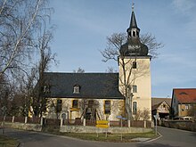
The church in Mannstedt was built in 1744/45.
In 1887 the community received a rail connection to Rastenberg, Buttelstedt, Weimar and Großrudestedt ( narrow-gauge Weimar – Rastenberg / Großrudestedt ). The Weimar-Rastenberger Eisenbahn-Gesellschaft operated this secondary line with meter gauge. The connection to Buttstädt was opened four years later, but was discontinued again in 1910 when the standard gauge line Buttstädt – Rastenberg was opened.
During the Second World War , Polish slave laborers had to work in Mannstedt from 1939 to 1940/41. They were quartered in an empty house at 11 Langen Strasse in Oberdorf. From 1942 the house and the manor served as overnight accommodation for Work Command 444, which was subordinate to Stalag IX C Bad Sulza . The prisoners of war from France and Serbia imprisoned there worked in agriculture.
On January 1, 2019, the Mannstedt community was merged with the other communities of the Buttstädt administrative community to form the Buttstädt rural community.
Population development
Development of the population:
|
|
|
|
Data source: Thuringian State Office for Statistics
politics
Municipal council
The municipal council from Mannstedt was composed of six members of a voting community (status: local election on June 27, 2004).
mayor
The honorary mayor Bernd Gramenz was elected on June 26, 2004.
coat of arms
The coat of arms is blue with silver flanks and shows a silver man with a black hat and belt and black boots, in his right hand a silver staff placed on the ground, the left hand propped up on his hip; in each of the flanks a green woad plant.
Individual evidence
- ↑ Thuringian Association of the Persecuted of the Nazi Regime - Association of Antifascists and Study Group of German Resistance 1933–1945 (Ed.): Local history guide to sites of resistance and persecution 1933–1945. Thuringia . tape 8 . VAS - Publishing House for Academic Writings, Frankfurt am Main 2003, ISBN 3-88864-343-0 , p. 272 .


