
Eßleben-Teutleben
|
Eßleben-Teutleben
Rural community of Buttstädt
Coordinates: 51 ° 9 ′ 8 ″ N , 11 ° 27 ′ 44 ″ E
|
|
|---|---|
| Height : | 209 m above sea level NN |
| Area : | 7.65 km² |
| Residents : | 287 (Dec. 31, 2017) |
| Population density : | 38 inhabitants / km² |
| Incorporation : | 1st January 2019 |
| Postal code : | 99628 |
| Area code : | 036373 |
 Location of the district Eßleben-Teutleben in the district of Sömmerda
|
|
Eßleben-Teutleben is a district of the rural community of Buttstädt in the Thuringian district of Sömmerda and consists of the two places Eßleben and Teutleben . It is right on the border between Thuringia and Saxony-Anhalt.
history
Teutleben
First documented mention in 876. There was once a moated castle southwest of the church near the confluence of the Rheinbach and Rohrbach. It belonged to the Lords of Teutleben , who were mentioned in a document in the 12th century. The remains of a round tower are still preserved today (see Teutleben castle ruins ).
Eating life
First documented mention in 1063 as a Usen life. At that time taxable to the Archbishop of Mainz . Later the community was in the possession of changing owners and in 1815 came completely to the Grand Duchy of Saxony-Weimar-Eisenach .
The Romanesque village church ( Lage → ) with the choir tower dates back to 1267. Since 2007 it has been called "Elisabeth Church". The galleries with fragments of screed decorations, which were probably applied in the twelfth century, are unique in Thuringia. The altar, richly decorated with carvings, is a special sight.
Forced labor
During the Second World War , 48 women and men from Poland , Ukraine and Italy had to do forced labor in agriculture.
present
The community Eßleben-Teutleben was founded in 1974 from the merger of Eßleben and Teutleben . This had belonged to the Buttstädt administrative association since 1991 .
On January 1, 2019, the municipality merged with the other municipalities of the Buttstädt administrative community to form the Buttstädt rural community .
Population development
|
|
|
|
Data source: Thuringian State Office for Statistics
Infrastructure
The two districts are connected by a simple country road that cuts through a corner of Saxony-Anhalt. Teutleben is on the L 1058 state road , which connects the place with Buttstädt in the west and Herrengosserstedt and Eckartsberga in the east.
politics
Former councilor
The local council from Eßleben-Teutleben was composed of six members of a free electoral group (status: local election June 27, 2004).

Main street in Eßleben with a view of the church
( camera position → )

coat of arms

Blazon : “Split of silver and green with a black shield base, inside a red-silver bar. In front a green linden tree and behind a silver tinned round tower with a black pointed roof. "
Meaning: The community of Eßleben-Teutleben takes up the motif of the community seal from the 19th century in its coat of arms and uses additional symbols to indicate historical and political characteristics of the community. Both communities Eßleben and Teutleben, which were independent communities until 1974, each had an unspecified deciduous tree in the seal in the 19th century. This motif is taken up in the design of the coat of arms and represented by a linden tree. This linden tree stands primarily for Eßleben. A tower was placed in the coat of arms for Teutleben, as there was once a moated castle belonging to the Lords of Teutleben. Remains of a round tower are still preserved today. The border to the state of Saxony-Anhalt - part of the connecting road between the two districts is already in Saxony-Anhalt - is symbolized by a red and silver bar. This also stands for the spatial separation of the two districts.
gallery
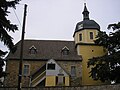
Church of Eßleben
( Location → )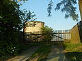
Tower mill in Eßleben

Exit from Eßleben
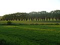
Weidenweg in Eßleben

Hof in Teutleben


Individual evidence
- ↑ Main statutes of the rural community of Buttstädt from July 8, 2019 , accessed on March 28, 2020
- ↑ Michael Köhler: Thuringian castles and fortified prehistoric and early historical living spaces , Jenzig-Verlag, 2001, ISBN 3-910141-43-9 , p. 246.
- ^ Website of the Ev. Church of Central Germany
- ↑ Thuringian Association of the Persecuted of the Nazi Regime - Association of Antifascists and Study Group of German Resistance 1933–1945 (Ed.): Heimatgeschichtlicher Wegweiser to places of resistance and persecution 1933–1945, series: Heimatgeschichtliche Wegweiser Volume 8 Thüringen, Erfurt 2003, p. 280 , ISBN 3-88864-343-0
Web links

Buttstädt | Ellersleben | Eßleben-Teutleben with Eßleben and Teutleben | Großbrembach | Guthmannshausen | Hardisleben | Kleinbrembach | Mannstedt | Olbersleben | Rudersdorf