Orlishausen
|
Orlishausen
City of Sömmerda
Coordinates: 51 ° 9 ′ 20 ″ N , 11 ° 11 ′ 31 ″ E
|
|
|---|---|
| Height : | 142 m above sea level NN |
| Area : | 10.55 km² |
| Residents : | 690 (Jul 31, 2010) |
| Population density : | 65 inhabitants / km² |
| Incorporation : | March 8, 1994 |
| Postal code : | 99610 |
| Area code : | 03634 |
|
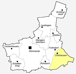
Location of Orlishausen in Sömmerda
|
|
Orlishausen is a district of the city of Sömmerda in the Thuringian district of Sömmerda . The place has an area of 1055 ha and 690 inhabitants ( as of July 2010 ).
geography
Orlishausen lies east of the core town of Sömmerda and is traversed by the Scherkonde . This comes from the direction of Vogelsberg and is dammed in front of Orlishausen to the Frohndorf dam to the southeast .
Neighboring places
Directly adjacent to Frohndorf in the north, Vogelsberg in the southeast, Sprötau in the south, Rohrborn and the core town of Sömmerda in the west.
history
The first documentary mention of Orlishausen is proven from 780–802.
The “Otterzunge” elevation, which extends into the Scherkonde Valley, was probably an early Bronze Age hilltop settlement, as a stone slab and an urn with a bronze find were found.
The places Groß- and Wenigenorlishausen belonged to that part of the county of Beichlingen , which in 1448 came to the Counts Botho zu Stolberg and Heinrich von Schwarzburg as the rule of Frohndorf and was sold to Hans von Werthern in 1505 . In the following years Orlishausen belonged to the Electoral Saxon Office Eckartsberga . In 1815, following a decision by the Congress of Vienna , the village and other southern locations of the Eckartsberga district did not become part of Prussia , but rather to the Grand Duchy of Saxony-Weimar-Eisenach . This incorporated the place in 1817 to the Buttstädt office . After the administrative reform of the Grand Duchy, the place came in 1850 as the only place of the dissolved Buttstätt district legally to the district court district Großrudestedt and administratively to the administrative district Weimar . Orlishausen has been part of the state of Thuringia since 1920.
During the Second World War , 50 forced laborers from Russia and France had to do forced labor in the village.
In 1992 a 17.2 hectare industrial area "Gebind" was created on the southern edge of Orlishausen. Orlishausen was incorporated into the district town of Sömmerda in 1994 .
politics
The current local mayor is Heike Streckhardt.
Attractions
- Heilandskirche with cemetery: in the western part of the village
- Tower of the Church of St. Peter and Paul, which burned down in 1971, and cemetery: in the eastern part of the village
- War memorial. It was built in 1923 from Clingen tuff and, due to its dilapidation, replaced in 1992 by a new memorial with a different shape and text: “The dead admonish. In memory of the victims of both world wars and the Stalinist tyranny ”.
Personalities
- Karl-Hermann Kästner (* 1946), lawyer and university professor
- Oswald Chancellor (1883–1944), local politician and party functionary of the SPD
- Johann Peschel (1535–1599), pastor
Individual evidence
- ^ Wolfgang Kahl : First mention of Thuringian towns and villages. A manual. 5th, improved and considerably enlarged edition. Rockstuhl, Bad Langensalza 2010, ISBN 978-3-86777-202-0 , p. 214.
- ↑ Michael Köhler: Pagan sanctuaries. Pre-Christian places of worship and suspected cult sites in Thuringia. Jenzig-Verlag Köhler, Jena 2007, ISBN 978-3-910141-85-8 , pp. 223-224.
- ↑ Thuringian Association of the Persecuted of the Nazi Regime - Association of Antifascists and Study Group of German Resistance 1933–1945 (Ed.): Local history guide to sites of resistance and persecution 1933–1945. Thuringia . tape 8 . VAS - Publishing House for Academic Writings, Frankfurt am Main 2003, ISBN 3-88864-343-0 , p. 280 .
- ^ Orlishausen on the website of the city of Sömmerda
- ^ Elections in Thuringia. Retrieved April 4, 2020 .


