
List of cultural monuments in Sömmerda
In the list of cultural monuments in Sömmerda , all cultural monuments of the Thuringian district town Sömmerda and its districts are listed (status: 2006).
Sömmerda
Local article: Sömmerda
Monument ensembles
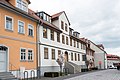
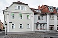
Marketplace
The ensamble includes the following addresses: Marktplatz 1–11, 17–23.
Marketplace 6

Marketplace 7

Marketplace 8
Marketplace 9
Marketplace 11

Marktplatz 18, 19, 20, 21

Marketplace 19

Marketplace 20

Marketplace 21

Marketplace 22


Goethestrasse
The ensamble includes the following addresses: Goethestraße 1/2, 5/6, Schillerstraße 1 / 2,10 / 11.
Petriviertel
The ensamble includes the following addresses: Petriplatz 1 - 11, Pfarrstrasse 4 - 11, Riedtorstrasse 1 and 2, Wachtelstrasse 14 - 17 and Brunnenhäuschen.

Pfarrstrasse 7

Individual monuments
Churches
| image | designation | location | Dating | description | ID |
|---|---|---|---|---|---|
 More pictures |
City Church of St. Boniface | Marketplace 1/2 (map) |
|
||
 More pictures |
St. Peter's Church | Petriplatz 1/2 (map) |
with equipment |
|
|
 |
Catholic Church of St. Francis | Weißenseer Strasse 44 (map) |
|
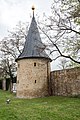
City fortifications
Longer sections of wall, wall towers and a gate have been preserved from the city fortifications:
- Wall section east of Parkweg 1 ( Lage )
- Round tower with conical roof opposite Parkweg 2 ( location )
- Round tower with conical roof opposite Parkweg 2 ( location )
- Round tower with conical roof opposite Karl-Marx-Straße 1 ( location )
- Round tower with conical roof opposite city ring 14 ( location )
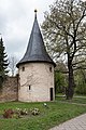
- City gate, so-called Erfurt Gate ( location )
- Round tower with conical roof opposite city ring 20 ( location )
- Round tower with conical roof opposite city ring 29 ( location )

City wall on Parkweg, city side
Round tower opposite Parkweg 2

Round tower opposite Parkweg 4
Round tower opposite Karl-Marx-Straße 1

Round tower opposite the city ring 14

Erfurter Tor, city side

Erfurter Tor, field side

Round tower opposite city ring 20

Round tower opposite city ring 29


Secular buildings
| image | designation | location | Dating | description | ID |
|---|---|---|---|---|---|
 More pictures |
Dreyse mill | Adolf-Barth-Strasse 25 (map) |
Dreysemühle with adjacent buildings and mill moat |
|
|
| Memorial for the Wars of Liberation 1813/14 | (In the cemetery?) |
|
|||
| Residential building | Bahnhofstrasse 2 (map) |
|
|||
| Residential building | Bahnhofstrasse 7 (map) |
|
|||
| Residential building | Bahnhofstrasse 21 (map) |
|
|||
| Residential building | Bahnhofstrasse 24 (map) |
|
|||
 More pictures |
Residential building | Bahnhofstrasse 37 (map) |
|
||
| Former Martini brickworks, canteen | Erfurter Strasse 43/44 (map) |
|
|||
 More pictures |
Residential building | Karl-Marx-Strasse 1 (map) |
|
||
| Municipal cemetery | Kölledaer Strasse (map) |
with a cemetery chapel and historical grave complexes and stones |
|
||
| Christian Gotthilf Salzmann School | Kölledaer Strasse 29 (map) |
|
|||
 More pictures |
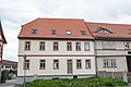
town hall | Marketplace 3–4 (map) |
|
||
 More pictures |
Rectory | Marktplatz 5 (map) |
the gospel. Regional municipality (formerly the office building) |
|
|
 More pictures |
Hotel "Zum Schwan" | Marktplatz 11 (map) |
|
||
 More pictures |
Salzmann monument | Marketplace in front of the Bonifatius Church (map) |
|
||
 More pictures |
Residential building | Parkweg 1 (map) |
|
||
 More pictures |
Fire station | Parkweg 4a and Brunnenstraße 7 (map) |
|
||
| Parish yard of the St. Petri parish | Pfarrstrasse 7 (map) |
|
|||
| TA building | City ring 5 (map) |
|
|||
| Waidstein | City ring (map) |
|
|||
| House (ground floor) with cross vault (demolition) | Thälmann-Strasse 10 (map) |
|
|||
| Residential building | Uhlandstrasse 5 (map) |
|
|||
| Residential building | Uhlandstrasse 19 (map) |
|
|||
 More pictures |
Residential building | Weißenseer Strasse 3 (map) |
|
||
 More pictures |
Home of the Dreyse family | Weißenseer Strasse 15 (map) |
|
||
 More pictures |
Residential building | Weißenseer Strasse 24 (map) |
|
||
| Residential building | Weißenseer Strasse 29 (map) |
|
|||
 More pictures |
Residential building including farm yard | Weißenseer Strasse 42 (map) |
|
||
 More pictures |
BWS (formerly Robotron) | Weißenseer Strasse 52 (map) |
Administration (building no. 4000), electrical workshop (building no. 4004), main cash desk (building no. 4100), cultural center (building no. 4200 / later 4500), mechanical engineering (building no. 4216), water tower (building no.4308), adding machine I (building no.4332), adding machine II (building no.4333), production building (building no.4400), new typewriter building (building no. No. 4900). Today the seat of the local court |
|
|
| Company school | Weißenseer Strasse 56 (map) |
with gate, gatehouse and transformer station (building no.4016). Today the site of a building materials market. |
|
||
| city Park | (Map) | with Stadtparkbrücke and Wegestein |
|
||
| Brickyard Park | (Map) | with Ziegeleiparkbrücke |
|
Frohndorf
Local article: Frohndorf
- Individual monuments
| image | location | Official name | description |
|---|---|---|---|

|
Am Mühlgraben (former street of construction 4) coord. |
Church of St. Anna with furnishings , cemetery (orphaned); historical tombstones are to the right and left of the entrance and on the southwest corner of the church | |

|
Ernst-Thälmann-Str. 1 coord. |
Residential building | |

|
Dorfplatz 14 (formerly Strasse des Friedens 14) coord. |
Rectory | |
|
Coord. |
Cellar of the former property (Frohndorf district, hall 3, parcel 60/8), behind school square 1a |
Leubingen
Local article: Leubingen
- Individual monuments
| image | location | Official name | description |
|---|---|---|---|

|
Road to Sömmerda Koord. |
Church with equipment | |

|
Road to Kölleda 1 coord. |
Residential building | |

|
Road to Kölleda 11 coord. |
Rectory | |

|
Am Leubinger Markt 1 coord. |
formerly well including storage facility, today ruin | |
| Werner-Seelenbinder-Str. 1 coord. |
Residential building | ||
| Werner-Seelenbinder-Str. 4 coord. |
Residential building | Seat of Heimatfreunde Leubingen eV and local history museum |
Orlishausen
Local article: Orlishausen
- Individual monuments
| image | location | Official name | description |
|---|---|---|---|

|
Unterdorf, Untere Kirchgasse Koord. |
Heilandskirche with equipment | |

|
Oberdorf, Obere Kirchgasse Coord. |
Tower of the former Church of St. Peter and Paul, which burned down in 1971. | |

|
Village square "Galgenhügel" Koord. |
Waidmühlstein | Note: Gallows Hill is usually called a former place of execution outside a local location. A 228 m high hill in the southwest of the village, about 3 km away, actually too far away to have served as a gallows hill, is called "Galgenberg". According to locals, there is no place called a village square in Orlishausen. The Waidmühlstein is not far from the war memorial on the meadow at Karlsplatz. There is a street called “Am Waidstein”, but there is no Waidmühlstein. |

|
Alexanderstraße 133 Coord. |
Courtyard | |

|
Mühlgasse 180 coord. |
Old age part | |

|
Schloßvippacher Strasse 2 coord. |
Inn from 1869 | The property is z. Partly inhabited, the restaurant is in the state of renovation (June 2016). The picture shows the entrance area as a partial view. More pictures can be seen in the Wikimedia Commons category of cultural monuments in Sömmerda. |
Rohrborn
Local article: Rohrborn
- Individual monuments
| image | location | Official name | description | |
|---|---|---|---|---|

|
Rohrborner Dorfstrasse (south of houses 36/37) coord. |
St. Michael Church and furnishings | ||

|
Rohrborner Dorfstraße (east of house 7) coord. |
Waidstein and Waidmühlenpfeiler |
Schallenburg
Local article: Schallenburg
- Individual monuments
| image | location | Official name | description |
|---|---|---|---|

|
Dorfstrasse 56 coord. |
St. Cyriakus Church with fittings and churchyard with enclosure including historical gravestones | The historical gravestones cannot be found in the cemetery. You could be in church. |

|
Dorfstrasse 59 Coord. |
Courtyard | |

|
Dorfstrasse 12 coord. |
Courtyard |
Schillingstedt
Local article: Schillingstedt
- Individual monuments
| image | location | Official name | description |
|---|---|---|---|

|
Kirchstrasse 7 | Church with furnishings and churchyard with selected gravestones and churchyard wall | |
| On the B 85 | Post mill | ||
| Edelmannsgasse 16 | Courtyard | ||
| Kirchstrasse 2 | Rectory | ||
| War memorial |
Stödten
Local article: Stödten
- Individual monuments
| image | location | Official name | description |
|---|---|---|---|

|
Friedensstrasse 1 coord. |
Liebfrauenkirche with equipment | |
| Friedensstrasse 22 Coord. |
Courtyard | The property was demolished around 2014 due to dilapidation. |
Tunzenhausen
Local article: Tunzenhausen
Monument ensemble
| image | location | Official name | description |
|---|---|---|---|
|
|
Coord. |
Church Platz der März-Gefallenen 1 (former parsonage) Hauptstraße 2 (former inn "Weißes Ross") Residential building Carl-Schleusing-Straße 7 (overall structure) |
.jpg)


Individual monuments
| image | location | Official name | description |
|---|---|---|---|

|
Hauptstrasse 2 coord. |
Church of St. Peter and Paul with furnishings | |

|
B 176 (at monument 1) coord. |
Memorial stone of the March Fighters | |

|
Cemetery coord. |
Memorial stone of the March Fighters | The memorial stone described does not exist in the old or new cemetery, only this memorial to those who died in war. |

|
Hauptstrasse 3 coord. |
Courtyard | |

|
Place of the fallen in March 1 coord. |
former rectory | |
| 3rd place of the fallen in March 3 Koord. |
kindergarten | Note: According to the association "Altes Gutshaus" Tunzenhausen eV , house number 3 has been assigned to the now listed old manor house. The discrepancy is being clarified (Sept. 14, 2016). |
Little summer
Local article: Little summer
- Individual monuments
| image | location | Official name | description |
|---|---|---|---|

|
Vorderstraße 49 coord. |
Church of St. Nicholas with furnishings | |

|
Vorderstraße 56 coord. |
Courtyard | |

|
Vorderstraße 61 coord. |
Courtyard | The building is uninhabited and in ruins. |

|
Vorderstraße 86 coord. |
Courtyard | The building is torn down. Last known voluntary place of residence of Anna Hohmann, who was murdered in the Nazi killing center in Bernburg in 1941 . A stumbling block in the sidewalk reminds of this . See also: List of stumbling blocks in Sömmerda . |

|
Vorderstraße 76 coord. |
Waidstein on the village square | According to local residents, there is no such thing as the “village square”. The Waidmühlstein is in front of the house at Vorderstraße 76. |
source
- Thuringian State Office for Monument Preservation: List of monuments of the Sömmerda district (PDF; 85 kB)
Web links
Alperstedt | Andisleben | Büchel | Buttstädt | Eckstedt | Elxleben | Gangloffsommern | Gebesee | Griefstedt | Großmölsen | Großneuhausen | Großrudestedt | Favored | Hatred life | Kindelbrück | Kleinmölsen | Kleinneuhausen | Kölleda | Markvippach | Nöda | Ollendorf | Eastern amondra | Rastenberg | Riethgen | Riethnordhausen | Ring life | Castle Vippach | Schwerstedt | Sömmerda | Sprötau | Straussfurt | Udestedt | Vogelsberg | Whale life | Weissensee | Werningshausen | Witterda | Miraculous life