Rohrborn
|
Rohrborn
City of Sömmerda
Coordinates: 51 ° 8 ′ 28 " N , 11 ° 9 ′ 18" E
|
|
|---|---|
| Height : | 167 (165-175) m above sea level NN |
| Residents : | 208 (2014) |
| Incorporation : | March 14, 1974 |
| Postal code : | 99610 |
| Area code : | 03634 |
|
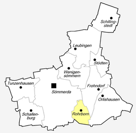
Location of Rohrborn in Sömmerda
|
|
|
St. Michael village church (2016)
|
|
Rohrborn is a district of Sömmerda in the Sömmerda district in Thuringia .
location
Rohrborn is located about four kilometers as the crow flies southeast of the district town of Sömmerda on the edge of the Unstrut valley . The highest elevation is the Galgenhügel ( 232.1 m above sea level ), which rises east of the village. Another elevation is the guard hill ( 207.6 m above sea level ). To the east of Rohrborn, the newly built federal motorway 71 leads past the village in a slight curve. The closest junction is in Sömmerda.
history
The village Rohrborn was first mentioned in a document on December 13, 1327. The occasion was the transfer of property and income in Rohrborn to the Augustinian monastery in Erfurt by the knight Hermann von Vippach .
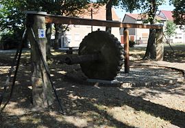
In the Middle Ages, Rohrborn belonged to the Sömmerda office and came into the possession of the city of Erfurt as a woad cultivation area . Even today, a Waidmühlstein as a technical monument attests to this special agricultural culture. The Rohrborn Church was built with funds from the Erfurt city council. In 1802 Rohrborn came to Prussia as part of the exclave of the Sömmerda Office, to the French Principality of Erfurt in 1807 and to Prussia again in 1814. In 1816, like Sömmerda, the place was attached to the Prussian district of Weißensee .
According to a statistical study, the village of Rohrborn had 222 Protestant residents around 1840. 46 houses, 76 stables and barns, six meetinghouses and a school were mentioned. A teacher taught the school-age 25 boys and 24 girls. At that time, Rohrborn mainly operated agriculture. The artisanal weaving and textile production was present with a line loom. The overview names a baker, a shoemaker, seven maids and two servants as other commercial and craft businesses. The total livestock consisted of 30 horses, 1 donkey, 85 cattle, 213 sheep, 18 goats and 46 pigs. The village corridor was 1081 acres , of which the agricultural area was 1044 acres of arable land, 6 acres of garden land, 22 acres of meadow and 9 acres of pasture. The yield of the fields was estimated as mediocre.
Attractions
- The oldest building in Rohrborn is the essentially Romanesque St. Michael Church ; in fact, it is the foundation area of the tower. The current nave, however, was not added to the still existing tower to the west until the beginning of the 17th century. There is an incised inscription from 1626. After the Seven Years' War , a large-scale repair was carried out in 1763 and in 1936 a comprehensive interior renovation was initiated. In 1992 the nave and tower were re-covered.
- The Rohrborn Waidmühle is a technical monument . It was set up again in the center of the village on a private initiative in 1986. The Waidmühlstein was on a hill near the village, where it was called Hügelstein . The stone pillars had survived as the gate posts of the rectory, a rarity in their original condition. The mill has been functional again since 2009. At that time they celebrated a big woad mill festival. (In the picture, the Waidstein is covered with a tarpaulin to protect it from rain and snow.)
- In the immediate vicinity of the Waidmühle is the "Drei-Kaiser-Eiche". It was planted in 1888, the three emperor year , under the supervision of the village mayor Friedrich Althanß.
- In the center, z. B. on the green area near the village pond, there are a number of boundary stones , all of which have been somewhat restored. Author's assumption: They were collected and brought here, so they are no longer in their original place.
- See also: List of cultural monuments in Sömmerda # Rohrborn
Gallery of landmarks
"J700", probably a Jagenstein with the serial number 700 (back blank)
See also: Description of the corridors , which (also) concerned the boundary stones.
literature
- Frank Boblenz : Rohrborn. City of Sömmerda. Sömmerda district. Waidmühle. Uwe John (Red.): State capital Erfurt, district Gotha, Ilm-Kreis, district Sömmerda, city Weimar, district Weimarer Land (= cultural discoveries Thuringia. Vol. 3). Schnell & Steiner, Regensburg 2010, ISBN 978-3-7954-2461-9 , pp. 210-212.
- Frank Boblenz: Rohrborn. City of Sömmerda. Sömmerda district. St. Michael Church. In: Sparkassen-Kulturstiftung Hessen-Thüringen (Hrsg.): Cultural discoveries - sites of the Reformation in Hesse and Thuringia. Schnell & Steiner, Regensburg 2014, ISBN 3-7954-2910-2 , pp. 278-279.
Individual evidence
- ^ Thuringian State Office for Road Construction: Road map of Thuringia. 1: 200,000. Erfurt 2009.
- ↑ Oldest documents - Homepage of the Rohrborn community
- ^ Enno Bünz : From the history of the village "Sulza" near Erfurt: A contribution to desert research in Thuringia. In: Hans-Otto Pollmann (Hrsg.): Archeology and building research in Erfurt (= small writings of the association for the history and antiquity of Erfurt eV 5). Association for the history and archeology of Erfurt, Erfurt 2001, ISBN 3-9807188-8-3 , pp. 95–116, here p. 100: Map " The rural area of the city of Erfurt around 1500. "
- ↑ Carl August Noback : Detailed geographical-statistical-topographical description of the administrative district of Erfurt. Self-published, Erfurt 1841, p. 207 .
- ^ History of the St. Michaeliskirche - Homepage of the Rohrborn community
- ^ Wolfgang Landgrebe: Sömmerda. In Wolfgang Grebe Country: Region Center and North (= .. Activities guide Thuringia attractions, landscape and nature, recreational sports, heritage, culture, festivals, events Vol. 1). Wartberg Verlag, Gudensberg-Gleichen 1999, ISBN 3-86134-550-1 , p. 142.


