
Lapidarium Willrode

The Lapidarium Willrode is a collection of historical boundary and district stones on the grounds of the forester's house Willroda near the Thuringian capital of Erfurt .
An exhibition of Thuringian boundary stones has been set up on the western side of the courtyard since 2009. The exhibitor is the Thuringia Regional Association of the DVW - Society for Geodesy, Geoinformation and Land Management (DVW) . There are currently (November 2011) around thirteen boundary and district stones with well-labeled explanatory boards. The collection presents markings of the external borders of historical territories. Initials on the head of the stones or their coat of arms indicate the respective rule. For example, “KP” stands for the Kingdom of Prussia , while “HG” refers to the Duchy of (Saxony) Gotha . Further marking stones show the initials of the marking or the consecutive numbering.
history

Before the duchies and principalities listed below (excluding Prussia) were merged to form the State of Thuringia in 1920, the following independent domains existed on Thuringian territory:
- Principality of Reuss older line (residence in Greiz )
- Principality of Reuss younger line (residence in Gera )
- Grand Duchy of Saxony-Weimar-Eisenach (residence in Weimar )
- Duchy of Saxony-Meiningen (residence in Meiningen )
- Duchy of Saxe-Coburg (residence in Coburg )
- Duchy of Saxe-Gotha (residence in Gotha )
- Duchy of Saxony-Altenburg (residence in Altenburg )
- Principality of Schwarzburg-Rudolstadt (residence in Rudolstadt )
- Principality of Schwarzburg-Sondershausen (residence in Sondershausen )
- Kingdom of Prussia (residence in Berlin )
After 1945 the Prussian administrative district of Erfurt was added. In 1952 it was divided into the districts of Erfurt, Gera and Suhl . After the fall of the Berlin Wall , the districts were united and the Free State of Thuringia was formed by adding the districts of Artern , Schmölln and Altenburg.
For historical reasons, the measurement methods and accuracy were very different in historical times. In earlier centuries, high-precision measurements to determine the position of boundary points were technically not possible and were missing. In order to still be able to prove the original position if the boundary stone was lost or moved, an object (" landmark stoneware ") was dug under the stone when it was first set , which specifically identified the respective ownership. Before the metric system was introduced in Germany on January 1, 1872, different measures of length were in use. For example, the Prussian rod (“Prussian work rod”) measured 3.766 m, while the Weimar rod (“Weimar wood rod”) was 4.512 m long. Agricultural areas in Prussia were referred to as " (Magdeburger) Morgen " (2,553.2 m²), but in Weimar as "Acker" (2,849.7 m²).
One of the most important tasks of a state, if only for the exact calculation of taxes and duties, has always been the measurement and definition of its borders. Afterwards, the cadastral survey is used to determine the property boundaries, corridors and parcels . However, in the 19th century, the states each introduced their own independent cadastral systems to document property relations. The cadastral registers contained the parcels with number, area, owner and type of use. After measuring the boundary stones and defining the parcels, large-scale maps were made.
Hallways
During the “Flurzügen” (corridor inspections), the integrity of the boundary stones was checked in places until the 19th century.
The descriptions of these “corridors” in the old reports from the 18th century are interesting and amusing. In the past, the fields were delimited by landmarks. The work of setting stones and measuring was done by the "Steiner" (also Steiniger ), who were responsible for measuring the corridors and setting the milestones as well as for settling border disputes. The number and location of the stones were recorded in a book that was kept in the church to be on the safe side. The parcels were depending on the size and shape of different names: it is of Gelenge , Sottel , Striegel , Miter and Girn spoken. Once a year the population moved to the fields in order to migrate the boundary stones with great participation, including the children, and to compare them with the entries in the church register. It was a feast day for the whole village. Since not all stones could be found intentionally or unintentionally in the intended place, there were also disputes, which is also indicated by field names such as "armed forces". So initially the borders to the neighboring villages were checked. And every time you came across the delegation from the next neighboring village, you greeted each other warmly and asked them to come to us for a drink .
After pacing the municipal boundaries, the boundaries of the corridors and parcels were moved and the boundary stones were checked, some were erected again or moved to the intended place. In the evening they met in the tavern, where 32 buckets and 5 cans were opened and drunk on that day . 1 bucket as the room size at that time was 72 cans or 67.362 liters. In the case described, the guests drank more than 2,100 liters there .
Pictures from the lapidary
Many stones were aligned in such a way that the correspondingly labeled / marked side pointed in the direction of the area that is meant by the labeling.
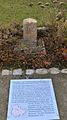
Boundary stone from the Bad Frankenhausen district to mark the border to an area that belongs to the Duchy of Schwarzburg-Rudolstadt . The stone bears the "Schwarzburger fork" as a national emblem.

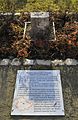
Langensalza boundary stone from 1731 with the three towers that can still be found today in the Bad Langensalza coat of arms. The stone was subsequently painted in color.
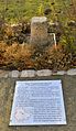
Border stone between Klettbach and Schellroda . You can see the "K" for Klettbach.

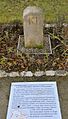
Border stone between Kurmainz and Hessen in the south of the Eichsfeld . The stone bears the “ Mainzer Rad ” as a sovereign mark and once marked the border between Wendehausen and Wanfried , and later the inner-German border .
Border stone between Obernissa and Eichelborn . The "O" on the side visible here stands for Obernissa, while the reverse bears an "E" for Eichelborn.
Border stone between the Kingdom of Prussia and the Duchy of Saxe-Coburg and Gotha . The "KP" stands for Kingdom of Prussia. The reverse bears the letters "HG" for the Duchy of Gotha. The stone stood between Wandersleben and Apfelstädt and had to be recovered and removed in the course of the construction of the A 4 motorway.

Border stone between the Kingdom of Prussia and the Duchy of Saxony-Meiningen . The initials "KH" stand for the Electorate of Hesse .

Border stone between the Kingdom of Prussia and the Duchy of Saxony-Weimar-Eisenach . The stone stood on the border between Schellroda and Bechstedt-Wagd and has signposts.

"Dreiherrenstein" on the Rennsteig

Border stone between the Grand Duchy of Saxony-Weimar-Eisenach and Vierzehnheiligen . "HSM" stands for the Duchy of Saxony-Meiningen.

Border stone between Thuringia and Bavaria. The initials "KB" refer to the Kingdom of Bavaria, the "W" below them to the Hochstift Würzburg .


literature
- Nikolaus Philippi: Landmarks in Germany - Origin and history of the landmarks as stone witnesses in the forest and the field. Rockstuhl Verlag, Bad Langensalza 2009, ISBN 978-3-86777-125-2 .
- Manfred Kastner, Ulrich Rüger: The Rennsteig - Historic Landmarks. Rhino-Verlag, Ilmenau / Wüstrow 2008, ISBN 978-3-939399-05-6
- Steffen Raßloff : Stone small states. To the lapidarium in Willroda. In: Thüringer Allgemeine from August 18, 2012
swell
- Flyer of the Lapidarium
Web links
- DVW website
- Website of the DVW-LV Thuringia
- Website of the Association of Friends and Supporters of the Forsthaus Willrode eV
- Lapidarium Willroda on erfurt-web
Coordinates: 50 ° 55 ′ 3.9 " N , 11 ° 5 ′ 21.3" E