Bechstedt-Wagd
|
Bechstedt-Wagd
Municipality of Wachsenburg
Coordinates: 50 ° 54 ′ 19 ″ N , 11 ° 3 ′ 56 ″ E
|
|
|---|---|
| Height : | 352 m above sea level NN |
| Residents : | 292 (Jun 1, 2010) |
| Incorporation : | March 14, 1974 |
| Incorporated into: | Egstedt |
| Postal code : | 99334 |
| Area code : | 0361 |
Bechstedt-Wagd is a district of the municipality of Wachsenburg in the Ilm district ( Thuringia ) with around 260 inhabitants.
geography
Bechstedt-Wagd is located on the edge of the Thuringian Basin about ten kilometers south of Erfurt . In between are the Wiesenbachtal and the Steigerwald . To the west of Bechstedt-Wagd are wide, flat arable land, while to the east of the village is the “Bechstedter Holz”, part of the large mixed deciduous forest area in the Erfurt - Weimar - Kranichfeld triangle . The village corridor is drained to the southwest towards the Wipfra . Bechstedt-Wagd is about 360 meters above sea level and has its addition ("Wagd") to better distinguish it from Bechstedtstrasse, which is only about 15 kilometers away . The ridge east of the Gera between Erfurt and Arnstadt used to be called Wagd . Bechstedt-Wagd is the northernmost place in the Ilm district.
history
The first settlements in the area of the present-day town existed around the year 700. A falsified document from the monk Eberhard in the Codex Eberhardi contains a donation from Charles III. des Dicken dated Sept. 23, 885. The document really does exist, but the monk Eberhard has changed the place “Pechstat” (Bechstedt) to “Perhstat,” Berstadt . In the Codex Eberhardi he then wrote “Berstat.” Bechstedt-Wagd was first mentioned in a document towards the end of the 12th century. At that time it belonged to the Counts of Henneberg until Count Johann I sold it to the city of Erfurt in 1355 for 169 silver marks . In the following 500 years it was one of the Erfurt villages and thus contributed to the supply of the city of Erfurt. The occasional opinion that Bechstedt-Wagd was a kitchen village , however, lacks the fact that it served the Kurmaizischer Hof in Erfurt. The associated duties and privileges did not affect the residents of Bechstedt, however.
With the reduction of Erfurt under the Mainz crook, it belonged to the Archdiocese of Mainz from 1664 . In 1802 it fell to Prussia together with the city and the city office of Erfurt . When the Prussian district of Erfurt was formed in 1816 , Bechstedt-Wagd was added to it. On March 14, 1974, the Egstedt community was incorporated into the district. In 1994 the district of Erfurt was dissolved as part of the Thuringian regional reform. Large parts of the old district were incorporated into Erfurt, including Egstedt (on July 1, 1994), but not the Bechstedt-Wagd district. It was incorporated into the Kirchheim community on June 30, 1994 . On January 1, 2019, Kirchheim was incorporated into the Wachsenburg district.
During the GDR era there was an NVA military training area to the east of the town , which was cut through by the A 4 . Even today (2010) there are numerous warning signs in the popular hiking area “Bechstedter Holz” (between Riechheimer Berg and Forsthaus Willrode ): “Stop! Former military area. Danger from duds! No entry! ”In the east of Bechstedter Holz, companies have been disposing of huge underground ammunition stocks in cordoned-off areas since the end of the GDR.
Economy and Infrastructure
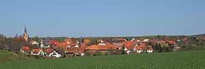
Bechstedt-Wagd is an agricultural place. Today, however, most of the residents work in nearby Erfurt. Closely connected courtyards with residential buildings, stables, barns and gardens determine the village structure with the character of a typical clustered village . Spacious kitchen gardens create a transition to the open landscape. Various houses and farmsteads in the village are listed. The Kaiserwiese ( location → ) with around 18 different rare plant species is known in the area . Bechstedt-Wagd is on the busy state road from Erfurt to Stadtilm , for which there is a bypass that has significantly improved the residential and leisure value of the place. Another road leads to Rockhausen in the west of the village. In addition, the proceeds A4 of the place a few hundred meters north.
Attractions
In addition to a number of listed buildings, the church of St. Trinity is a special attraction. It was extensively restored in the baroque style in 1724 .
Individual evidence
- ^ Stefan Alles, Lampert von Hersfeld and Eberhard von Fulda. Two learned monks as critical representatives of their neighboring imperial abbeys in the upheavals of the 11th and 12th centuries. A comparative appraisal of the environment, work and importance from a regional historical perspective. Dissertation Marburg 2011, p. 171.
- ↑ Municipalities 1994 and their changes since January 1, 1948 in the new federal states , Metzler-Poeschel publishing house, Stuttgart, 1995, ISBN 3-8246-0321-7 , publisher: Federal Statistical Office
- ↑ Thuringian Law and Ordinance Gazette No. 14/2018 p. 795 ff. , Accessed on January 3, 2019


