
Kirchheim (Wachsenburg Office)
|
Kirchheim
Municipality of Wachsenburg
|
|
|---|---|
.png) |
|
| Height : | 250 m |
| Area : | 21.31 km² |
| Residents : | 1274 (December 31, 2017) |
| Population density : | 60 inhabitants / km² |
| Incorporation : | 1st January 2019 |
| Postal code : | 99334 |
| Area code : | 036200, 0361 (Bechstedt-Wagd) |
Kirchheim ( ) is a district of the municipality of Amt Wachsenburg in the Ilm district in Thuringia ( Germany ).
geography
Geographical location


Kirchheim is located northeast of Arnstadt on the Wipfra , a tributary of the Gera . It is the administrative seat of the administrative association Riechheimer Berg , of which it has not been a member since 2019.
Neighboring places
Clockwise, starting in the north: Rockhausen , Erfurt , Klettbach , Elleben , Elxleben , Alkersleben , Arnstadt, Amt Wachsenburg
Districts
- Bechstedt-Wagd (261 inhabitants)
- Kirchheim (752 inhabitants)
- Werningsleben (204 inhabitants)
history
The first documentary mention of Kirchheim was in December 1074. Even then, Kirchheim referred to a "settlement near the church". As the seat of the deanery with 16 villages, the place later acquired a special significance. Its history was determined by changeable rulers. From 1343 to 1357 the place belonged to the Counts of Henneberg , who, together with the castle and the Ilmenau office, bought it from Count Günther von Käfernburg the Younger for 2000 marks of soldered silver. In 1414 the Carthusian monastery in Erfurt acquired all the property in Kirchheim from the Ichtershausen monastery. In the Middle Ages, the place was considered to be wealthy because of the largest woad cultivation area in the region and the seven woad mills, and a monastery and an estate also contributed to this.
Until 1802 the place belonged to the city office in the Electoral Mainz area of the city of Erfurt . In 1802/03 the Erfurt area became part of Prussia and between 1807 and 1814 it became part of the French Principality of Erfurt . With the Congress of Vienna , the town came back to Prussia with the Erfurt municipal office and in 1816 it was incorporated into the Erfurt district in the Prussian province of Saxony . In 1932 the community came to the Prussian district of Weißensee and in 1950 to the Thuringian district of Arnstadt .
In 1923 the former monastery property of the Carthusian monastery in Erfurt (169 hectares) was managed by tenant Ernst Schmidt.
Kirchheim was and is an agricultural place. The farmers and goods then went the way of agriculture in the Soviet Zone and GDR. After the reunification they reoriented themselves.
In 2018, 92 percent of the citizens voted for integration into the neighboring municipality of Amt Wachsenburg. This was implemented on January 1, 2019.
Population development
Development of the population:
|
Data source: from 1994 Thuringian State Office for Statistics - values from December 31st
politics
Former councilor
The Kirchheim parish council consisted of 12 councilors and councilors.
- KBW 4 seats
- FWG 7 seats
- The left 1 seat
(Status: municipal council election on June 7, 2009)
Former mayor
The honorary mayor Hans-Jürgen Langer (FWG) was elected on June 7, 2009.
coat of arms
Blazon : "In red with a green shield base a golden church with a left tower, three (2: 1) silver six-spoke wagon wheels floating above the roof."
Partnerships
There is a partnership with the municipality of Kirchheim am Neckar in Baden-Württemberg .
Attractions
Observatory
The Volkssternwarte Kirchheim, built in 1969, is located in Kirchheim .
Village church
The church consecrated to St. Lawrence has existed since 1357. It was built in place of a previous building.
The tower
The tower was built between 1400 and 1440. New bells have been ringing in the tower since 1921. In 1993 a radio-controlled tower clock and a new dial were installed.
The inner

Inside, the sandstone relief from the time the tower was built, which represents the Mount of Olives, is particularly worth seeing. The relief probably consists of parts of the previous church and was later attached to the current location. In 1685 the baroque baptismal table with a carved group of figures ( Baptism of Jesus ) was donated by the Beyer brothers from Arnstadt . The ceiling painting from 1898 with biblical scenes is the work of the painter Ernst Liebermann . The sacristy received a renovation in 1989. Further renovation work began in 1996. In 2006 the font was restored and presented to the public on the occasion of the exhibition “A Thousand Years of Baptisms in Central Germany” in Magdeburg Cathedral . The late Gothic carved altar with painted outer wings was created around 1440 in an Erfurt workshop. The valuable Wagner organ is currently (2016) not playable and is to be refurbished for around 80,000 euros.
Further renovation work
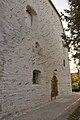
Since the church was threatened by dry rot and other renovation work was urgently needed, the church has been extensively restored since autumn 2010 under the supervision of the architect Peter Tandler from Erfurt. The nave was given a new pavement using historical brick slabs that were still preserved. The plaster and lighting are also new. The previously closed galleries are accessible again, the foundations under the supports have been renewed and a statically effective wooden disc has been installed and connected to the west gable. On the south side of the church (see picture) part of the wall surface was plastered, so that you can already have an idea of what the church might look like later. An outside staircase and the path lighting are still missing. The entrance doors and the main entrance can be used again. In autumn / winter 2011 the church roof was given a new slate covering, and on November 18, 2011, a festive button festival was celebrated.
The “Foundation for the Preservation of Church Monuments” ( KiBa Foundation ) named the church Church of the Year 2015 in Germany.
More pictures of the church

Entrance gate on the west side from 1699
West wall with building moisture removal hoses

Refurbishment work on a window on the north side

Gravestone in the churchyard
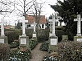
Hereditary funeral of the landowner family


Sports
The amateur football club SG Eintracht Kirchheim 46 is based in Kirchheim.
Personalities
- Johann Andreas Buttstedt (1701–1765), rector in Osterrode am Harz, Hildesheim, Gera, Coburg and professor at the University of Erlangen
- Gerhard Neumann (1907–2004), painter and graphic artist, lived in Kirchheim from 1946 to 1950
- Liane Bahler (1982–2007), cyclist, was born in Kirchheim
- Kathleen Frontzek (* 1993), actress, born in Kirchheim
- Lisanne Frontzek (* 1995), actress, born in Kirchheim
- Adrian Frontzek (* 1998), actor, born in Kirchheim

Half-timbered house

Half-timbered house

Half-timbered house

View through Arnstädter Straße to the church

Half-timbered barn

Courtyard gate to the former monastery property

Inscription above the entrance gate of the former monastery property "1566"

Former manor house


Individual evidence
- ^ Wolfgang Kahl : First mention of Thuringian cities and villages. A manual. Rockstuhl Verlag, Bad Langensalza, 2010, ISBN 978-3-86777-202-0 , p. 142
- ↑ Cyriacus Spangenberg: Henneberg Chronica of the ancient, laudable Graven and princes of Henneberg. Strasbourg, 1599, p. 195
- ↑ Presentation of the location on vg-riechheimer-berg.de, seen on June 16, 2014
- ↑ Jürgen Gruhle: Black Book of Land Reform Thuringia. Retrieved June 20, 2011 ( Memento July 7, 2010 in the Internet Archive )
- ↑ Kirchheim citizens vote to move to the Wachsenburg office
- ↑ Thuringian Law and Ordinance Gazette No. 14/2018 p. 795 ff. , Accessed on January 3, 2019
- ^ Source for Schwarzburgische and Saxon places: Johann Friedrich Kratzsch : Lexicon of all localities of the German federal states . Naumburg, 1843. Available online from Google Books . Source for Prussian places: Handbook of the Province of Saxony. Magdeburg, 1843. Available online at Google Books
- ^ Michael Rademacher: German administrative history from the unification of the empire in 1871 to the reunification in 1990. Population figures. (Online material for the dissertation, Osnabrück 2006).
- ↑ Population development since 1989 (TLUG) ( Memento of the original from October 29, 2012 in the Internet Archive ) Info: The archive link has been inserted automatically and has not yet been checked. Please check the original and archive link according to the instructions and then remove this notice. (PDF; 18 kB)
- ^ Website of the Friends' Association of the Church
- ^ Newspaper article in the Thüringer Allgemeine from May 2011