
Thörey
|
Thörey
Municipality of Wachsenburg
Coordinates: 50 ° 53 ′ 12 ″ N , 10 ° 56 ′ 37 ″ E
|
|
|---|---|
| Height : | 252 m above sea level NHN |
| Residents : | 242 (Dec. 31, 2010) |
| Incorporation : | January 24, 1974 |
| Incorporated into: | Ichtershausen |
| Postal code : | 99334 |
| Primaries : | 03628, 036202 |
 St. Wenceslas village church ( location → )
|
|
Thörey is a district of the municipality of Amt Wachsenburg in the Ilm district ( Thuringia ) with around 250 inhabitants.
geography
Thörey is located in the Thuringian Basin in the city triangle Erfurt - Gotha - Arnstadt at an altitude of about 260 meters. The surrounding area consists of flat farmland.
history
Thörey was first mentioned in a document in 948. The unusual place name comes from Germanic and roughly means the hill of the Thor , which suggests that the pagan Thuringian tribes held the area sacred until the 8th century. In the area around Thörey there was also an area of activity of Boniface , who proselytized here in the first half of the 8th century and recorded the founding of the town in writing. The first name of the village was Dorehug , later Thoronua ", from about 1850 Thörey .
Albrecht von Grumbach, probably a son of the founder of the Ichtershausen monastery (Marquard von Grumbach), transferred his estate in Thörey to this monastery in 1176. In 1346 the Counts von Gleichen also owned goods in Thörey, which were then also given to the Ichtershausen Monastery by Count Hermann. This did not survive the Peasants' War in 1525 and thus lost its goods. Thörey was then a predominant farming village, the oldest house dates from 1593. The place now belonged to the Wachsenburg office with Ichtershausen , which in 1640 belonged to the Duchy of Saxe-Gotha , from 1672 to the Duchy of Saxe-Gotha-Altenburg and in 1826 to the Duchy of Saxe-Coburg and Gotha came.
Thörey was occupied by US troops in April 1945 , which were replaced by the Red Army in early July . This made it part of the Soviet Zone and, from 1949, of the GDR . In 1958/59 an LPG was founded .
Until 1920 the village belonged to Saxe-Gotha , then to the district of Arnstadt or today's Ilm district , which essentially emerged from the old district of Arnstadt. On January 24, 1974, the place was incorporated into the community of Ichtershausen . Since the merger of the municipality of Ichtershausen with the Wachsenburg municipality on January 1, 2013, Thörey has belonged to the municipality of Wachsenburg.
Attractions
- Village church “St. Wenceslas ” : It was built from around 1100 to 1174, and rebuilt and expanded in the 15th century and the Renaissance period. In the 1980s the roof was in danger of collapsing, and security work began in 1991. A small metal sign next to the side door indicates that the church was then extensively renovated with the support of the German Foundation for Monument Protection . Inside there are remains of wall paintings from the 13th century. The old churchyard wall still exists, but the cemetery is now across the street.
- A war memorial in the cemetery commemorates 14 soldiers who died and went missing in World War I and 21 soldiers who went missing in World War II.
- The restored building of the community backhaus is located on the attractively designed village square . There you can also see numerous boulders and the contained spring, the Krebsbrunnen , from which a small stream is forwarded.
- There are still some half-timbered houses in the village, the "Roter Hirsch" restaurant is particularly beautiful
- As a compensation measure for the heavy land consumption by the industrial area, the Riethgraben south of it was renatured from 2007, the adjacent areas were planted with trees and bushes and two ponds were created. A new footpath and bike path connects Thörey, Rehestädt and Ichtershausen. The cost was 550,000 euros. This cycle path ends about 1 km before Rehestädt or Ichtershausen.

Old, restored bakery

Crab Well

Church, south side

Church, tower door
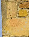
Church, sundial on the southwest corner of the tower

War memorial in the cemetery


Economy and Infrastructure
Thörey is located on Erfurt cross and thus on the motorways A 4 and A 71 . The A4 junction Neudietendorf is on the corridor . On the western outskirts of the village, the 77 hectare (net area) industrial park Ichtershausen-Thörey-Autobahn (GITA) was built in the 1990s .
Originally the economy of the village was mainly characterized by agriculture. Agroland Agrar e. , Which emerged from the KAP Thörey founded in the 1970s, is still today . G. Thörey / Rehestädt is one of the largest farms in the Ilm district, which also cultivates most of the agricultural land in the Wachsenburg community .
Roads connect Thörey with Neudietendorf in the north, Arnstadt in the south and Ichtershausen in the east.
Web links
Individual evidence
- ^ Thörey on the Ichtershausen website
- ↑ Municipalities 1994 and their changes since January 1, 1948 in the new federal states , Metzler-Poeschel publishing house, Stuttgart, 1995, ISBN 3-8246-0321-7 , publisher: Federal Statistical Office