Erfurt motorway junction
| Erfurt motorway junction | |
|---|---|
|
|
|
| map | |
| location | |
| Country: | Germany |
| State : | Thuringia |
| Coordinates: | 50 ° 53 '39 " N , 10 ° 57' 18" E |
| Basic data | |
| Design type: | customized shamrock |
| Bridges: | 1 (motorway) / 5 (other) |
| Construction year: | 1996-1998 |
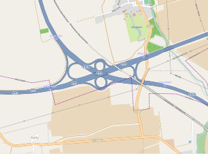
The motorway junction Erfurt (abbreviation: AK Erfurt ; short form: Kreuz Erfurt ) is a motorway junction in Thuringia . This is where the federal motorway 4 ( Aachen - Eisenach - Görlitz ) ( Europastraße 40 ) and the federal motorway 71 ( Sangerhausen - Schweinfurt ) intersect .
geography
The cross is located one kilometer southwest of the Erfurt district of Molsdorf on the Orgelberg and marks the southwestern edge of the Thuringian state capital Erfurt . Surrounding places are Thörey , Ichtershausen , Kornhochheim and Eischleben . It is located about 10 km southwest of downtown Erfurt and about 140 km northeast of Würzburg . The Erfurt Cross is part of the Erfurt Ring .
The Erfurt motorway junction is number 45 on the A 4 and number 12 on the A 71.
State of development
The A4 has six lanes in this area. The A 71 has four lanes. All ramps are single-lane.
particularities
The new Ebensfeld – Erfurt line bridges the eastern part of the motorway junction and both motorways, through the Geratalbrücke Ichtershausen , before it runs partially parallel to the A 71 in the direction of Coburg . The bridge structure has existed since 2000, when it was built in the course of the new construction of the A 71 and the motorway junction. Commissioning took place in December 2017.
Due to the crossing angle of the two highways, the clover-leaf shape of the cross is slightly modified.
Traffic volume
The cross is used by around 87,000 vehicles every day.
| From | To | Average daily traffic volume |
Share of heavy goods traffic |
||||
|---|---|---|---|---|---|---|---|
| 2005 | 2010 | 2015 | 2005 | 2010 | 2015 | ||
| AS Neudietendorf (A 4) | AK Erfurt | 58,300 | 47,900 | 58,000 | 15.4% | 18.5% | 17.4% |
| AK Erfurt | AS Erfurt-West (A 4) | 58,300 | 53,800 | 58,700 | 15.4% | 17.0% | 16.2% |
| AS Erfurt-Bindersleben (A 71) | AK Erfurt | 18,400 | 22,400 | 25,500 | 9.9% | 11.6% | 9.5% |
| AK Erfurt | AS Arnstadt-Nord (A 71) | 19,600 | 28,800 | 32,000 | 9.7% | 11.6% | 11.5% |
Individual evidence
- ^ AK Erfurt. Motorway junctions and triangles in Germany, 2011, accessed on November 18, 2012 .
- ↑ Manual road traffic census 2005. (PDF) Results on federal motorways. BASt Statistics, 2007, accessed on August 21, 2018 .
- ↑ Manual road traffic census 2010. (PDF) Results on federal motorways. BASt Statistics, 2011, accessed on August 21, 2018 .
- ↑ Manual road traffic census 2015. (PDF) Results on federal motorways. BASt Statistics, 2017, accessed on August 21, 2018 .

