
Kornhochheim
|
Kornhochheim
Rural community of Nesse-Apfelstädt
Coordinates: 50 ° 54 ′ 7 ″ N , 10 ° 54 ′ 54 ″ E
|
|
|---|---|
| Height : | 271 m |
| Residents : | 805 (December 1, 2009) |
| Incorporation : | March 14, 1974 |
| Incorporated into: | Neudietendorf |
| Postal code : | 99192 |
| Area code : | 036202 |
  Location of Kornhochheim in Nesse-Apfelstädt
|
|
Kornhochheim had been part of Neudietendorf in the east of the Thuringian district of Gotha since March 14, 1974 . Since December 1, 2009, Kornhochheim and Neudietendorf have been districts of the rural community of Nesse-Apfelstädt .

geography
Kornhochheim was originally laid out in the manner of a "rectangular" round square village on a hill on the southern edge of the Thuringian Basin south of the Weidbach , a tributary of the Apfelstädt . The south running Mühlkanal of the Weidbach is the border to the original district Dietendorf of the community Neudietendorf . Coming from Mühlberg , where it originated in the Spring , it drains the valley between Mühlberg and Neudietendorf and flows into the Apfelstädt at the end of Neudietendorf. The place was created west of the north-south connection from Arnstadt via Thörey to Neudietendorf, the so-called tree road. The church, along with the cemetery, was given the highest location on the southern outskirts.
Neighboring towns are Apfelstädt in the west (2 km), Sülzenbrücken in the south-west (3 km), Thörey in the south (3 km) and the Erfurt district of Molsdorf in the east (3 km).
history
Founded in the Middle Ages in the Wachsenburg district - the church dates back to the 12th century - belonged to the Duchy of Saxe-Weimar and from 1640 to Saxe-Gotha , from 1675 to Saxe-Gotha-Altenburg and from 1825 to Saxony -Coburg and Gotha . With the end of the monarchy after the First World War, he was assigned to the district of Gotha.
Kornhochheim was uninhabited for years during the Thirty Years War .
In 1939 the place had 353 inhabitants. With a territorial reform in the GDR , the community became part of the newly formed Erfurt-Land district . The previously independent Kornhochheim was incorporated into Neudietendorf in 1974. With the dissolution of the Erfurt Land district, the Neudietendorf community and with it the Kornhochheim district came back to the Gotha district. Since December 2009, Kornhochheim has been part of the first rural community in Thuringia, the community of Nesse-Apfelstädt . As part of a referendum on September 14, 2014, the majority of the rural community decided to give Kornhochheim the status of a locality, which means that it is now possible to appoint an independent local mayor and local council.
When American artillery bombarded the night from April 8th to 9th, 1945, the church tower, two houses, the school and several barns were hit, causing fires and killing one of the residents.

Building history and description of the place
Decisive for the design of the village square was definitely the abundant spring, called Davids-Born, that has existed up to our time . A closed row of stately two-storey farmhouses with the associated gate entrances was built on its north side. Most of the buildings were rebuilt in the second half of the 17th century after almost the entire town was destroyed during the Thirty Years War and was uninhabited for years. The residential buildings, but also the farm buildings from this era, were built as half-timbered houses with smoothly plastered facades. They regularly had partial basements with vaulted cellars made of natural stone masonry made from local limestone and sandstone. Noteworthy architectural details on the residential buildings are the large gates in the south facades, the window arrangements including the shops, the entrance hallways with staircases and occasional stucco work on the living room ceilings.
The northern, valley-side property boundary of the above-mentioned row of houses is framed by a medieval stone wall, the shape and construction of which can be found again as a cemetery wall in the village. Today the wall no longer exists in its entirety.

The " Schwemme ", the former village pond, dominates the south side of the village square . In the 20th century this water basin served primarily as a fire fighting pond; it was laid out in its existing form as an in-situ concrete pool before the First World War . In the centuries before it still had the real character of a village pond, at that time you could drive in the wooden horse-drawn carriages in dry summers to prevent the wheels from falling apart. The name “Schwemme” certainly indicates that horses, ducks and geese could also have a refreshing bath here.
Up until the 1980s, about 80 m further up in Kirchgasse, the structurally built main well of the village was found, which (still today) feeds the Schwemme. Eight households had house connections for this until the water pipes were destroyed by the renewal of the road surface on Kirchgasse. Today the well is channeled underground. Instead of the previous hand pump, only a simple manhole cover can be seen from the well. The water of this well and the flood flows together with that of Davids-Born in a small stream ( Flösschen ) under the half-timbered houses through and through the gardens of the properties and a few hundred meters in the side ditch of the main street to the side canal of the Waidbach, which the border to Neudietendorf represents.
The former school building is located directly at the church, at the southern end of Kirchgasse. It consists of an eastern half-timbered house, which was built in 1768 for "485 Reichsthaler with 2 rooms, 7 chambers, 1 barn and stables" and a western masonry structure, which was built around the turn of the century 1899-1900. In the last few decades the buildings were used as a community office, residential building and (still today) restaurant “Zur Alm”.
In the central area of the village square, south of the David Fountain, there was an interesting, one-story half-timbered building until after the Second World War . It served as a brewery and was also used as a fire station. Today there is a fire station as a modest functional building on this site.
In the course of the collectivization of agriculture in the GDR, the large farms with their buildings of the LPG were built southeast of the village center . Around 1980, around 1000 cattle were fattened in these buildings. Today's Landgut GmbH emerged from this, with around 680 hectares of agricultural land. In addition, from 1990 a large industrial area was opened up in the south of the village. It extends over around 50 hectares on both sides of the road to Thörey, almost as far as the motorway. Finally, the new settlement area "Am Berge" should be mentioned, which was opened up on about 16 hectares east of the road to Neudietendorf on the plateau south of the Kirchberg and built on with new single-family houses.
Picture gallery
- Pictures of the building history
Davids Born ( Location → )
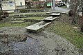
The Flood ( Location → )

Half-timbered house
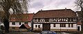
Half-timbered house


Economy and Transport
The originally agricultural place underwent a considerable change in the 20th century. Many of the town's residents now earn their livelihood in the south industrial area that was built in the 1990s south of Kornhochheim .
By Kornhochheim the provincial road 1044. leads to junction Erfurt of A 4 and A 71 is about 2 km to southeast. The Neudietendorf / Arnstadt West junction of the A 4 is located immediately south of the village .
Regular buses connect Kornhochheim with the district town of Gotha and with Neudietendorf, where there is a rail connection. The Neudietendorf train station, 1.5 km north of Kornhochheim, is on the Halle – Erfurt – Bebra and Neudietendorf – Ritschenhausen routes . Since April 2008 the place belongs to the area of the transport association Central Thuringia .
Worth seeing


- The Church of St. Nicholas (→ main article: St. Nicholas Church ) is of Romanesque origin and dates from the second half of the 12th century, the entrance portal from the 15th century. It is the most important historical sight of the place. The tower lost its characteristic spire due to artillery fire in 1945 and was rebuilt in 1952 in a simplified manner.
- To the south of the church, in a small oak grove, there is a memorial stone in the form of a menhir with the inscription “We warn”. It is a war memorial from the time after the First World War, modified during the GDR era . The plaques with the names of the fallen have been removed.
- Not far from the church is the huge, bizarre trunk of a largely dead linden tree as a natural monument .
- Kornhochheimer Kummelkreuz : In 2000 a five meter high oak cross was erected on the Kornhochheimer Kummel hill . It stands as a symbol of the peaceful reunification of Germany and was consecrated by Bishop Joachim Wanke on October 3, 2000. A memorial plaque on the cross names the Catholic St. Raphael community of Neudietendorf and the volunteer fire brigade as initiators for the erection of the cross .
Individual evidence
- ↑ a b c d Arndt Schumann: A walk through built history - From Kornhochheim to Neudietendorf , anniversary edition Neudietendorf 2000
- ^ Administrative history of the district of Gotha
- ↑ Horst Benneckenstein: Planned attack in the Brothers' inn . Thuringian newspaper, May 8, 2009
- ^ Statement by the Jacobi family, Kirchgasse 2, Kornhochheim
- ↑ "Kummelkreuz" is intended to commemorate the reunification in Kornhochheim . ( Memento from October 30, 2007 in the Internet Archive ) Press release from the Diocese of Erfurt from September 27, 2007