Apfelstädt (Gera)
|
Apfelstädt Apfelstedt |
||
|
Apple town in Wandersleben |
||
| Data | ||
| Water code | DE : 56426 | |
| location | Thuringia , Germany | |
| River system | Elbe | |
| Drain over | Gera → Unstrut → Saale → Elbe → North Sea | |
| source | South of Tambach-Dietharz in Stockwiese 50 ° 45 ′ 16 ″ N , 10 ° 34 ′ 26 ″ E |
|
| Source height | approx. 728 m above sea level NN | |
| muzzle | At Molsdorf in the Gera coordinates: 50 ° 55 ′ 15 ″ N , 10 ° 58 ′ 1 ″ E 50 ° 55 ′ 15 ″ N , 10 ° 58 ′ 1 ″ E |
|
| Mouth height | approx. 219.6 m above sea level NN | |
| Height difference | approx. 508.4 m | |
| Bottom slope | approx. 15 ‰ | |
| length | 34 km | |
| Catchment area | 372.2 km² | |
| Discharge at the gauge Ingersleben A Eo : 371.4 km² Location: 700 m above the mouth |
NNQ (regular) MNQ 1946–2005 MQ 1946–2005 Mq 1946–2005 MHQ 1946–2005 HHQ (06/10/1961) |
0 l / s 194 l / s 2.34 m³ / s 6.3 l / (s km²) 30.9 m³ / s 98.2 m³ / s |
| Left tributaries | Spitter , red | |
| Right tributaries | Schmalwasser, Ohra , Weidbach | |
| Small towns | Tambach-Dietharz | |
|
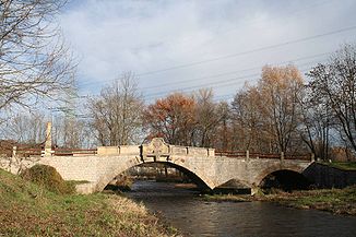
Marienthal Bridge near Ingersleben |
||
The Apfelstädt is a river in Thuringia with a length of about 34 km. From the end of the Tambach-Dietharz dam, it is a first-order body of water according to the Thuringian Water Act . The catchment area of the Apfelstädt is 372.2 km².
geography
The Apfelstädt rises below the Rennsteig at 728 m above sea level. NN about five kilometers southwest of Tambach-Dietharz . In the Thuringian Forest, the river marks the western border of the Elbe river system .
The Apfelstädt flows through ten districts: Tambach-Dietharz , Georgenthal (as well as OT Catterfeld and OT Hohenkirchen ), Herrenhof , Schwabhausen , Drei Gleichen (OT Seebergen , OT Wechmar and OT Wandersleben ) (here inflow of the Rot ), Nesse-Apfelstädt (OT Apfelstädt , OT Neudietendorf (tributary of the Weidbach from Mühlberg ) and OT Ingersleben ).
The Ohra is its main tributary, this flows north of Ohrdruf . The Apfelstädt flows into the Gera near the Marienthal settlement that belongs to Ingersleben , with the mouth already in the Erfurt district of Molsdorf .
Economic history
Up to the 20th century, the water in the apple town was important for up to 56 mills along its course. Today three of them are still in operation (Georgenthal, Wechmar and Ingersleben), while three more serve as technical museums (Tambach-Dietharz, Georgenthal, Wechmar). At least the buildings of 34 mills have been preserved, some with their mill technology. The raft ditch was built near Georgenthal in 1653 , which drains water from the apple town. Today it is used for fishing and occasionally by canoeists when the water level is high. At Petriroda, a pond fed by the Apfelstädt was created for irrigation. At Ohrdruf, the Apfelstädt flows through a military training area of the Bundeswehr . Here it is used for training to overcome water obstacles.
Attractions
- Most of the sights along the Apfelstädt can be admired on a hike on the Apfelstädtmühlen nature trail, which opened in April 2011 . It leads from the Neue Mühle near Schwabhausen for around 20 km downstream to the confluence with the Gera. The hiker passes more than 18 former mill locations. It is planned to extend the trail to the source.
- The border dolomite in the Apfelstädt near Wandersleben: a naturally formed terrain, geological boundary between the Lower and Middle Keuper at around 230 million years ago.
- A popular sight on the river is the Marienthal Bridge near Ingersleben . At the instigation of Count Gustav Adolf von Gotter , who was also the owner of the nearby Molsdorf Castle , the yellow sandstone bridge was built from 1751 to 1752 at the site of a ford .
gallery
The separation of the raft ditch (left) near Georgenthal
literature
- Birgit Hähnlein, Bernd Kramer, Alfred Kirsten: The Apfelstädt - A river in the course of time , Ed .: Ev.-Luth. Apfelstädt parish, Apfelstädt, 2002
Individual evidence
- ↑ Elfriede Ulbricht: The river basin of the Thuringian Saale . 1st edition. Max Niemeyer, Halle (Saale) 1957.
- ↑ a b Topographic map 1: 25,000
- ↑ Level: Ingersleben On: hnz.tlug-jena.de
- ↑ Official Gazette of the district of Gotha from May 5, 2011


