Spitter
| Spitter | ||
|
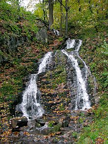
Small cascades are typical of the Spitter upper reaches |
||
| Data | ||
| location | District of Gotha , Thuringia , Germany | |
| River system | Elbe | |
| Drain over | Apfelstädt → Gera → Unstrut → Saale → Elbe → North Sea | |
| Source height | approx. 765 m above sea level NN | |
| muzzle | in Tambach-Dietharz in the Apfelstädt Coordinates: 50 ° 47 '44 " N , 10 ° 36' 55" E 50 ° 47 '44 " N , 10 ° 36' 55" E |
|
| Mouth height | 432.8 m above sea level NN | |
| Height difference | approx. 332.2 m
|
|
| Small towns | Tambach-Dietharz | |
The Spitter is a 6.5 km long stream near Tambach-Dietharz . It rises from several swamp springs in the area of the Ebertswiese and flows through the Spittergrund, a flat valley floor that is up to 50 m wide and formed by meadows and moist high herbaceous meadows. After a 1.5 km run, the Spitter falls in 3 cascades over the rock step made of Hühnberg rock. The Spitterfall is one of the highest waterfalls in Thuringia. The Spitter flows into the Apfelstädt in Tambach-Dietharz and thus belongs to the Saale and Elbe river systems , which drain to the North Sea. The Spitter is the only stream in the Thuringian Forest whose headwaters are located south of the Rennsteig , the ridge path over the low mountain range . The Spitter has a richly structured stream bed and is therefore a habitat for a species-rich river fauna. Faunistic investigations by entomologists from the Museum der Natur Gotha using the so-called emergence collecting trap method produced numerous finds of stoneflies , mayflies and other insects, including rare species, in the 1970s to 1980s .
Tributaries
The Spitter takes on several short tributaries. The longest is the Rotebach coming from the Rotebachswiese and flowing into it on the left.
natural reserve
The valley of the Spitter is protected as a nature reserve "Spittergrund".

